


KANSAS CITY, Mo. — The National Weather Service issued tornado and severe thunderstorm warnings and watches Tuesday morning/afternoon in the Kansas City area.
Just before 4:30 p.m., the threat was cleared by NWS.
—
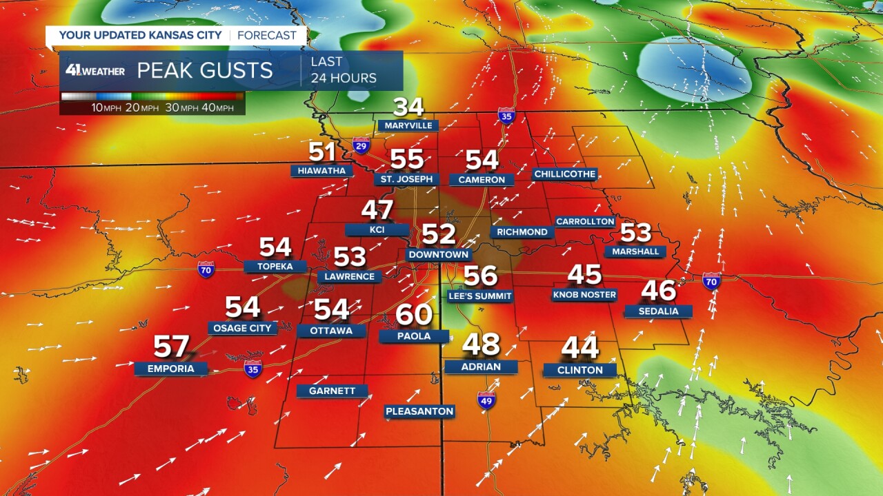
6:46 p.m. | Blustery conditions are widespread across the metro.
The winds contributed to a 50-foot-tall tree going down near 7th and Osage in Leavenworth County.

The emergency manager reported minor injuries and said the situation will be "here for a while."
Of the four cars, the one in the middle of the street was driving when the tree fell.

4:25 p.m. | NWS reports the severe weather threat across the Kansas City area has ended.
"There are no active severe weather watches, warnings or advisories in effect," the weather service shared on social media.
However, strong winds are still expected throughout the evening.
3:49 p.m. | All Missouri counties that were still under a tornado watch until 6 p.m. have been cleared — Adair, Chariton, Cooper, Howard, Linn, Macon, Pettis, Putnam, Randolph, Saline, Schuyler and Sullivan.
2:45 p.m. | The tornado watch issued until 6 p.m. has been canceled for the majority of northwestern Missouri. Adair, Chariton, Cooper, Howard, Linn, Macon, Pettis, Putnam, Randolph, Saline, Schuyler and Sullivan counties remain under the watch.
2:35 p.m. | Adair, Chariton, Linn, Macon, Putnam, Schuyler and Sullivan counties are under a severe thunderstorm watch until 3:15 p.m.
2:21 p.m. | Jackson, Caldwell, Cass, Daviess, Harrison and Ray counties have been removed from the tornado watch. Adair, Carroll, Chariton, Cooper, Grundy, Howard, Johnson, Lafayette, Linn, Livingston, Macon, Mercer, Pettis, Putnam, Randolph, Saline, Schuyler and Sullivan counties remain.
2:14 p.m. | A severe thunderstorm warning is in effect until 2:45 p.m. for Adair, Carroll, Chaiton, Linn, Livingston, Putnam and Sullivan counties.
1:43 p.m. | Missouri's Clay, Clinton DeKalb, Gentry and Worth counties are no longer under a tornado watch. However, the watch continues for the following counties until 6 p.m.: Adair, Caldwell, Carroll, Cass, Chariton, Cooper, Daviess, Grundy, Harrison, Howard, Jackson, Johnson, Lafayette, Linn, Livingston, Macon, Mercer, Pettis, Putnam, Randolph, Ray, Saline, Schuyler and Sullivan.
1:30 p.m. | The Severe Thunderstorm Warning in Bates, Cass and Johnson counties in Missouri have expired.
1:20 p.m. | An additional severe thunderstorm warning bringing the potential for quarter-size hail and 60 mph winds is in place until 2 p.m. in Caldwell, Carroll, Jackson, Johnson, Lafayette, Livingston and Ray counties in Missouri.
1 p.m. | An additional severe thunderstorm warning is in place until 1:30 p.m. in Bates, Cass and Johnson counties in Missouri. The impact of potential 60 mph winds could bring damage to roofs, siding and trees.
KSHB 41 meteorologist Lindsey Anderson says once these storms move through the area, you'll be in the clear for the remainder of the day.
Thunderstorms are entering more unstable air as they travel into western Missouri. Severe thunderstorm warnings are in place from Trenton down to Butler, MO for strong wind & hail. Once these storms pass through, you are in the clear for the rest of the day.@kshb41 pic.twitter.com/lIuf1WQfTV
— Lindsey Anderson (@lnanderson) April 16, 2024
12:50 p.m. | A severe thunderstorm warning that could bring penny-size hail and 60 mph winds has been issued by the NWS for Jackson, Lafayette and Ray counties until 1:15 p.m.
A severe thunderstorm warning is also in place in Grundy, Mercer, Putnam and Sullivan counties in Missouri. It could bring quarter-size hail.
12:24 p.m. | KSHB 41's Abby Dodge checked out the storm damage near Smithville.
She spoke with a utility company's spokesperson who said the downed power lines at 144th and Mount Olivet were likely caused by straight-line winds and not a tornado.

12:15 p.m. | The severe thunderstorm warning — which earlier covered Mercer, Grundy and Sullivan counties — is canceled.
12:10 p.m. | A severe thunderstorm warning is in effect until 12:15 p.m. for Mercer County in Missouri.
11:19 a.m. | Power outages across the Kansas City area currently stand at:
- Platte-Clay Electric Cooperative: 5 total outages, 379 affected
- Kansas City Board of Public Utilities: 5 total outages, 727 affected
- Evergy: 116 outages, 6,779 customers affected
11:14 a.m. | The severe thunderstorm warning has been canceled for Carroll and Ray counties. The warning continues until 11:45 a.m. for Caldwell, Daviess, Grundy, Harrison and Livingston counties.
11 a.m. | A severe thunderstorm warning has been extended until 11:45 a.m. in Caldwell, Carroll, Clinton, Daviess, DeKalb, Grundy, Harrison, Livingston and Ray counties in Missouri.
10:52 a.m. | Evergy reports 124 outages with 10,038 customers impacted. BPU reports 889 customers without power across three outages, while Independence has one outage impacting 39 customers. You can track the latest on Evergy's outage map.
10:47 a.m. | The severe thunderstorm warningg impacting northwest Missouri has been lifted in Cass, Clay, Clinton and Jackson counties in Missouri, and Johnson and Miami counties in Kansas.
The severe thunderstorm warning continues in Caldwell, Clay, Clinton, Daviess, DeKalb, Jackson and Ray counties in Missouri until 11 a.m.
The tornado watch throughout Missouri counties remains in place until 6 p.m.
10:45 a.m. | Following the storms, additional damage is being reported.
The Clay County Sheriff's Office says it is responding to storm-related damage at the Smithville Lake campgrounds. A camper turned over at the Camp Brand campground, five poles were downed near Mt. Olivet Road and NE 144th Street, a roof was blown off of the KC Trap Shooters Association building and trees were downed in the 17900 block of Collins Road.
Additionally, Main Street is closed in Parkville from 13th Street to Missouri 9 Highway due to a fallen tree. Drivers are advised to avoid the area.
10:35 a.m. | A severe thunderstorm warning in the Kansas City area was extended until 11 a.m. The warning includes Jackson and Clay counties.
Severe Thunderstorm Warning including Independence MO, Liberty MO and Excelsior Springs MO until 11:00 AM CDT pic.twitter.com/kJiBIjp38w
— NWS Kansas City (@NWSKansasCity) April 16, 2024
10:30 a.m. | A tornado watch was issued in counties throughout Missouri until 6 p.m.
The watch is impacting Jackson, Cass, Clay, Ray, Lafayette, Johnson, Clinton, Dekalb, Gentry, Worth, Caldwell, Carroll, Chariton, Daviess, Grundy, Harrison, Linn, Livingston, Macon, Mercer, Putnam, Randolph, Sullivan, Cooper, Howard, Pettis and Saline counties.
The tornado warning in Missouri counties has expired.
10:15 a.m. | A tornado warning has been issued for Smithville, Kearney and Holt in Clay, Platte and Clinton counties in Missouri until 10:30 a.m. Be prepared for possible tornadoes and pea-size hail.
Tornado Warning including Smithville MO, Kearney MO and Holt MO until 10:30 AM CDT pic.twitter.com/mJuwUkpD6x
— NWS Kansas City (@NWSKansasCity) April 16, 2024
10 a.m. | A severe thunderstorm warning is impacting the majority of the Kansas City area until 10:45 a.m. Wind gusts up to 60 mph and pea-size hail is possible.
Severe Thunderstorm Warning including Kansas City MO, Overland Park KS and Kansas City KS until 10:45 AM CDT pic.twitter.com/QUbNoHNyTM
— NWS Kansas City (@NWSKansasCity) April 16, 2024
KSHB 41 News meteorologist Jeff Penner captured the thunderstorms as they move through the metro.
The line of thunderstorms now moving through the west part of KC brought a brief 50-60 mph wind gust to south OP about 950 am. After this line exits KC between 11 am and noon, it should be dry, sunny and windy in KC the rest of the day. @KSHB41 pic.twitter.com/KOdiIJ0REY
— Jeff Penner (@JeffPennerKSHB) April 16, 2024
Osage County Emergency Management Director Gregg McCurdy said storms left a 20-mile debris path in Osage County from 293rd Street to Urish Road, and from SW Wanamaker Road to the Shawnee County line.
McCurdy said storms downed vegetables, outbuildings, trees and power lines.
A house with three people inside was hit by the storms. Three people self-transported to an area hospital. McCurdy believes they suffered minor injuries.
An RV containing two people was also blown over in the area. Both individuals refused treatment.
The town of Overbrook lost power briefly before it was restored.
7 a.m. | The tornado warning has been canceled, according to the NWS.
6:45 a.m. | The tornado warning has been extended until 7:15 a.m. It now includes Jefferson County, Kansas, and remains in Douglas County.
6:40 a.m. | A tornado warning was issued in Kansas, west of the Kansas City area, until 6:45 a.m.
The tornado warning includes Osage County, Shawnee County and Douglas County, west of Lawrence near Clinton Lake.
The activity is expected to stream northeast, not towards the KC area, according to the NWS.
Tornado Warning including Overbrook KS, Richland KS and Stull KS until 6:45 AM CDT pic.twitter.com/cLLOUBuwrp
— NWS Topeka (@NWSTopeka) April 16, 2024
You can track the latest on KSHB 41's weather radar.
![020626_KSHB_Image_NXA_Web_Standard Cube[88].jpg](https://ewscripps.brightspotcdn.com/dims4/default/0ead409/2147483647/strip/true/crop/300x225+0+13/resize/960x720!/format/webp/quality/90/?url=http%3A%2F%2Fewscripps-brightspot.s3.amazonaws.com%2F8f%2F6c%2Ffad8bd2346c5a4d4ead793017d4a%2F020626-kshb-image-nxa-web-standard-cube88.jpg)