

Good morning bloggers,
We are on a roller-coaster ride of temperatures this week:
- The week began with ONE lonely degree on Sunday morning
- Today will jump up to near 50 degrees this afternoon
- An Arctic blast will move in Wednesday with a chance of snow Wednesday night
- It will likely be our coldest morning of the season Thursday or Friday morning with below zero possible
- There will be another big warm up on Saturday into the 40s or 50s
Now, that is quite the ride of temperatures this week! Here is a look at the Arctic Blast that will blast southwest to the coastal areas of Washington.

A few hours after the Arctic Blast arrives Wednesday there will be a chance of snow. Once again, the models are all over the place. The most consistent one has been the European Model. Here is what showed for Wednesday night's snowfall potential:
SNOW FORECAST FROM EUROPEAN MODEL ENDING THURSDAY MORNING

The European Model has been consistently painting this band of accumulating snow across our region with wide spread 1 to 2 inch amounts. I like the consistency and there is some support from the other models. Here is the HRRR model that just came out this morning:
SNOW FORECAST FROM THE HRRR MODEL:

This model shows a dusting to 3" in the KC region, but notice the northern and southern edges of this forecast. This shows you one reason why we have another tough forecast on our hands. There will likely be around a 25 mile wide band in the middle of this snow swath that will have close to 4" of snow. Then, you get out 50 miles from there, and it may go down to a dusting or not even a snowflake.
The LRC & This Next System:
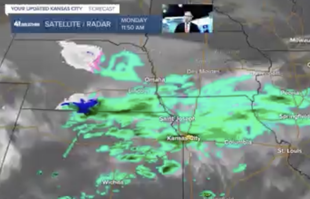
KSHB-41 Meteorologist Jeff Penner wrote the blog on November 1, 2021, just over two months ago. In his video, and I pulled a screenshot from the posted video and it is shown above. When this part of the pattern cycled through on November 1st, Kansas City experienced its first snowflakes. You may remember we had around a quarter inch of rain in the middle of a band moving in from the northwest and west. And, here we are, now in the second LRC cycle and radar may look similar to this on Wednesday night. It is right on schedule. This time, it is going to be much colder so there will be no rain and it will be all snow, but where will it track exactly?
I will go over all of the models and make some conclusions on KSHB-41 tonight. Wes Peery will be on the Midday show today at 11 AM with his analysis of the trend on the models as well. The models range from no snow to 4" of snow, so we have another challenging forecast.
For today, let's enjoy the warmer temperatures! It didn't even drop below freezing overnight as a result of this warm-up that is in progress. The Arctic front will move through tonight! Expect that high of near 50 degrees today.
Thank you for sharing in this weather experience and spending a few minutes of your day reading the weather blog. Have a great Tuesday!
Gary
