

Good morning bloggers,
Well, the streak continues! We did have our first heat wave in two years, but the streak of days without a 100 degree day goes on. The last 100 degree day in Kansas City was on July 12, 2018. Yesterday reached a hot high temperature of 98 degrees, our second 98-degree-day in a row. The dew points were extremely high for temperatures like this, and the high humidity levels are likely the reason the temperature didn't warm up just a couple more degrees. The Heat Index reached 120 degrees in a few spots.
The heat continues today south and west of a slow moving cold front. This front will move slowly the next two days. Thunderstorms keep missing Kansas City. Look at what happened last night near the front:

The red to pink to white enhanced clouds show the tops of the thunderstorms. You would think that they came close to KC, but they didn't. They did hit Trenton with some very heavy rain in northern Missouri, however. Look at the radar from around the time this satellite picture was taken:

Even though those clouds spread overhead after sunset, all of the thunderstorms had either fallen apart or moved into Illinois. So, Kansas City misses the rain again. There are a couple of rain chances showing up later today, and more likely on Saturday.
The next good chance of thunderstorms in our area will be centered near Kirksville, MO at 6 AM Saturday. Now, I say good chance because there is nearly a 100% chance this region will have rain, but Kansas City has a 20% chance later today and a 50% chance Saturday.
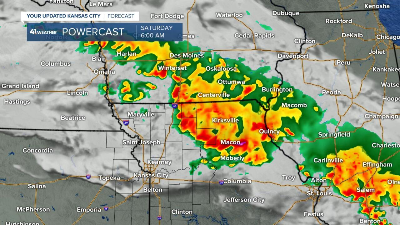
Thunderstorms will be developing over Iowa this evening and tracking southeast into the Kirksville, MO region. They may clip Chillicothe and Trenton, MO later tonight, but the chance farther southwest is much lower. And, we need the rain. While Kirksville approaches a foot of rain this month, Kansas City is much lower:

Even though we are nearly two inches of rain below average this month with two days to go, there is a chance that two inches of rain could fall in one hour this weekend. There is a stalling cold front right over the KC metro area right now, as I was writing this at 6:30 AM this morning. Take a look at the morning surface map:

The cold front is rather weak. A cold front is defined to be the leading edge of a cooler air mass, and it is in the 50s and 60s over the Great Lakes states, while it is near 80 degrees in Kansas City early this morning. So, it is the leading edge of slightly cooler air.
The chance of thunderstorms is around 20% in most locations today. There is a better than 20% chance just north of where the front lines up this afternoon and evening, and we will identify this location on our newscasts today and tonight. The front is stalling, so this chance is most likely going to be north of I-70 with the chance farther south less than 10%. Then, the chance of thunderstorms will increase to 50% in most areas Saturday as the front slowly moves south and cooler air begins moving in from the north and northeast.
2 inches of rain may fall in around an hour if you get underneath one of these thunderstorms the next two days. Many of our lawns could use that kind of drink of water and a few of us will likely get watered by Mother Nature. It will likely be spotty enough that many of us get left high and dry again.
Kansas City Weather Time-Line:
- Today: Excessive Heat Warning for the combination of heat and extreme humidity. Mostly sunny this morning. A few cumulus clouds building up this afternoon with a 20% chance of a thunderstorm where you live. High: 98° near Olathe, KS to 92° near Liberty, MO. Heat Index: 105°
- Tonight: A 20% chance of thunderstorms in KC with a 90% chance near the Iowa border north of Trenton. Low: 75°
- Saturday: There is a 50% chance of heavy showers and thunderstorms. Cooler air will begin moving in with the wind shifting to the northeast at 5-15 mph. High: 88°
- Sunday: Mostly sunny and a bit cooler. A nice summer day with a northeast breeze at 5-15 mph. High: 85°
We hope you are enjoying the Olympics on KSHB-41 each day. We will keep you updated today and tonight as this cold front moves through. Thank you for spending a few minutes of your day reading today's Weather Blog. Have a great Friday Night In The Big Town.
Gary
