


KANSAS CITY, Mo. — Good Wednesday, bloggers,
We have an interesting assortment of weather to track the next seven days. We have a frost advisory in some locations, a developing hurricane, and two systems that will bring rain to our very dry area.
Let's go through this.
FROST ADVISORY:
There is a frost advisory for northern Missouri this morning and Thursday morning. It will be a few degrees colder Thursday morning, so there is a better chance of frost at that time.
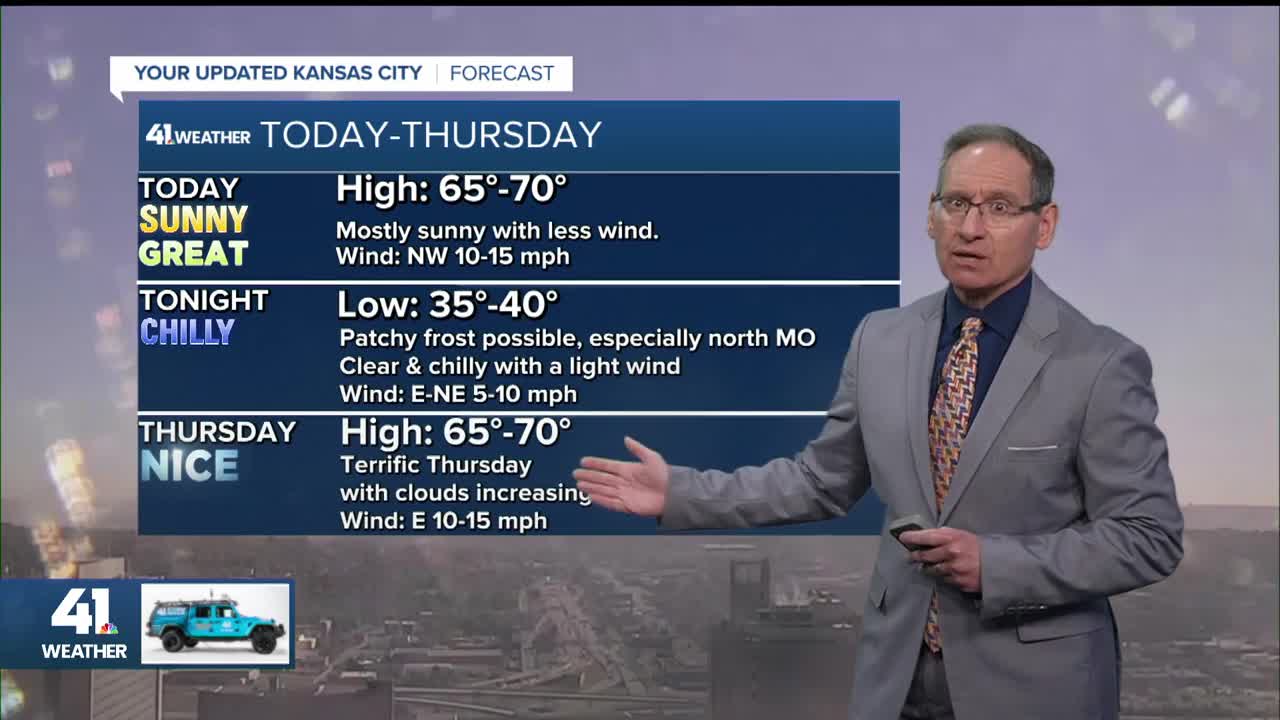
This morning, lows are mostly from the mid-30s to low 40s, which is a bit too warm for frost.

The frost advisory extends from northwest Kansas to Iowa and Kentucky. There is a small freeze warning north of Omaha.

Lows Thursday morning will be a few degrees colder than this morning as a weak front slips through this evening. Lows across northern Missouri will be 30°-37°, so some locations may see their first freeze. All other locations will be mostly in the mid- to upper 30s.
The last 10-14 days of October are just about the average time when we see our first frost, and the first freeze occurs across northern Missouri.

TROPICAL SYSTEM MELISSA:
Melissa is a tropical storm this morning with 50 mph winds located south of Haiti and the Dominican Republic.

Melissa will likely become a Category 1 hurricane by the end of the week. Melissa will drift north/northwest this week toward Jamaica before taking off to the northeast into the Atlantic next week, missing the U.S. coast.

RAINFALL FORECAST:
We are tracking two storm systems between Friday and Tuesday. They will combine to bring several periods of rain and drizzle.
The rain will mostly be light with a few heavier periods. It is hard to time out and pick out the locations of the heavier rain.
Right now, it looks like Friday morning and Saturday evening/night have the best chance to see heavier rain.
Friday-Tuesday will see little to no sunshine, periods of rain with temperatures mostly between 53° and 63°.
The heaviest overall rain will likely occur from Oklahoma to northwest Arkansas into southwest Missouri and southeast Kansas, where rainfall may add up to 4"-7".

In our area, the heaviest will be south of Interstate 70, where amounts will range from 2"-4" south to 0.10"-0.50" north.

When we zoom in, the Friday-Tuesday rainfall potential ranges from 0.10"-0.50" across northern Missouri to 1"-2" south of I-70.
The new data is a bit wetter, and hopefully the trend will continue so that the rainfall totals will all be in the 1"-2" category.

This is the percent average rainfall for the last 30 days, when we average 3.5"-4" of rain. It is no secret that it is dry, with most percentages between 25% and 50%.
There is a small streak of around 100% of average from Atchison, Kansas, to Chillicothe, Missouri, which mostly occurred last weekend.
Also, from Bethany, Missouri, to Clinton, Missouri, there are percentages higher than 100%. This occurred about two weeks ago in one morning from a cluster of T-storms that dropped south, east of Kansas City.

We have not forgotten the weather for Monday Night Football, as the forecast is still tough. It will depend on how fast the second storm moves.
We have solutions ranging from the rain is long over by kickoff to the rain chances don't exit until early Wednesday.
Have a great rest of your week!
Stay healthy.
—
