


KANSAS CITY, Mo. — Good Thursday bloggers,
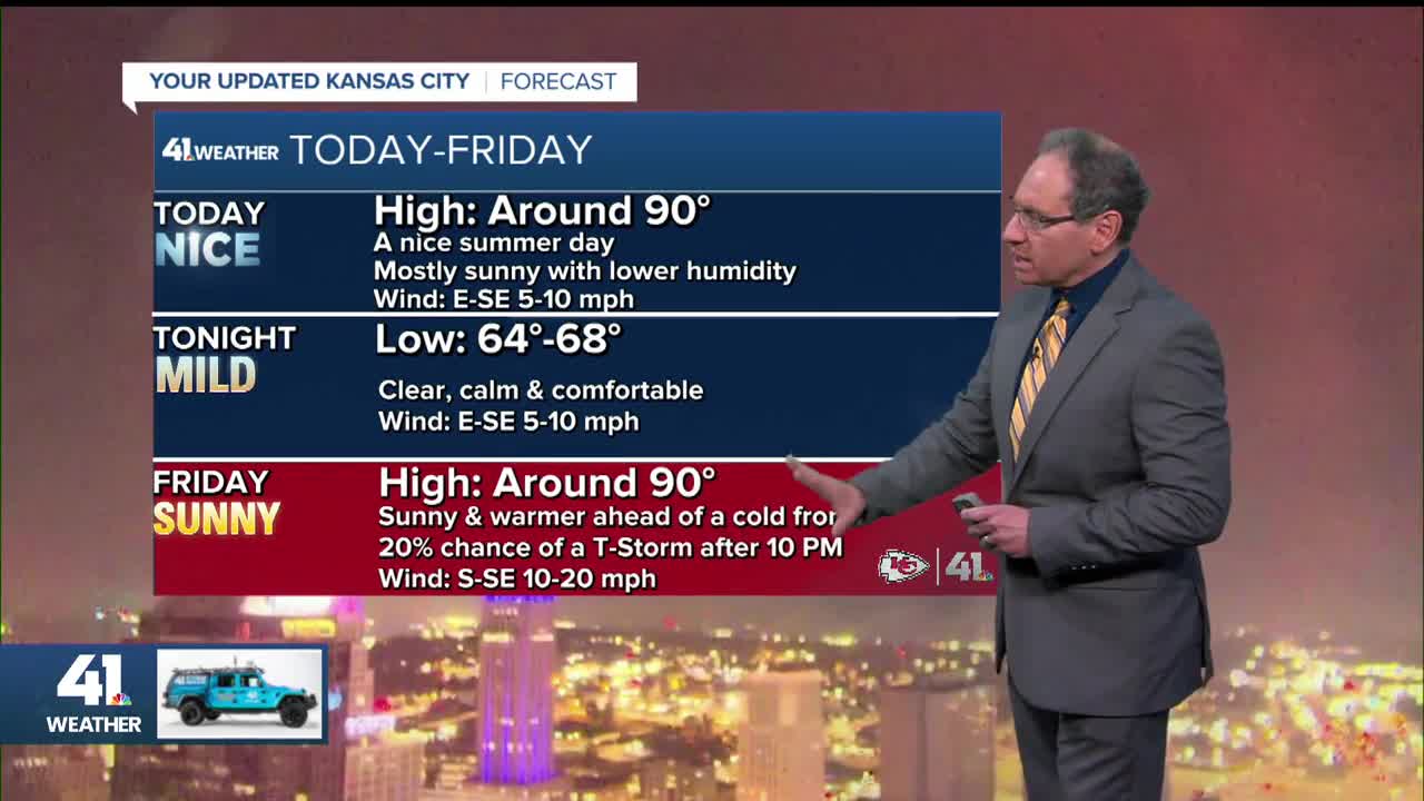
We have been tracking two cold fronts this week. The 1st one ended the heat wave, but it did not get rid of the hot weather. Now, it has taken the edge off of the heat and humidity. Highs today and Friday will be near 90° with moderate humidity.
TODAY:
The high heat will be out west as the 1st front becomes a warm front and starts to head back east. We will see some low clouds this morning. If they hang around long enough, highs today will be in the mid-80s.

FRIDAY:
The warm front will be on our doorstep pushing the high heat to just west and northwest of our area. It is being forced east ahead of a 2nd, stronger cold front.
This means it will be dry and hot for tailgating out at Arrowhead for the Bears vs. Chiefs. There will be a south-southeast breeze at 10-20 mph to help a bit.

Scattered showers and thunderstorms will form on the front across Nebraska and Iowa. It looks like these will stay northwest of Kansas City until after midnight. This means it should be dry for the game as temperatures drop from around 90° during tailgating to the mid-70s by the 4th quarter.

SATURDAY:
Scattered showers and thunderstorms are possible Saturday as the cold front moves through. Some locations may see .10"-1" while some do not see a drop.

Highs Saturday will be in the 70s where rain and clouds linger to the low 80s where the sun comes out. Highs will be in the 50s and 60s across Minnesota, Wisconsin and north Iowa, where it will be cloudy and really feel like fall.

SUNDAY MORNING:
Lows here will likely drop to the 50s as the front pushes south and stalls. Lows may drop to the 40s in northeast Iowa to Minnesota and Wisconsin.

SUNDAY AFTERNOON:
Highs will be near 80° as thunderstorms track across southwest Kansas. Highs will be in the 60s across Iowa, Minnesota and Wisconsin.

NEXT WEEK:
The upper level flow will be coming in from northwest Canada on the west side of a big upper low over Hudson's Bay. The heat dome will be located over southwest Texas.

This means temperatures next week will be running 10-20 degrees below average for most locations east of the Rockies. In August, this means comfortable temperatures as the average high around here is 85°. We will see highs in the 70s with lows in the 50s.
Now, a map like this in January means were are in for a very cold stretch of weather. We will worry about that kind of weather later.

This is a photo from Gary Tripp in Raymore of the moon with Mercury closest to the horizon, Venus near the moon and Jupiter above and to the right of Venus. Saturn, I believe is up and to the left of the moon. You have to look close for Mercury and Saturn.
These planets will be visible in the east morning sky the rest of the month, pretty cool.

Have a great weekend
Stay healthy
