


Good Monday, bloggers,
We talked over the weekend about knowing we will see flash flooding set up in the area. But we did not know where the heaviest rain would set up.
As it turned out, the rain Sunday morning ended up pushing the heaviest to southern Kansas, as close as just south of Emporia.
Radar estimated totals over the last three days show the heaviest rain across southern Kansas, where 1"-4" of rain has occurred. It is still adding up.
There was a second band of 1"-4" rainfall the last three days from southern Nebraska to southern Wisconsin. Milwaukee received around 10" of rain in a 12-hour period over the weekend, causing major flash flooding.

When you zoom in on our area, we have quite a variety of rainfall totals. Rainfall ranged from 3" between Buckner and Odessa to a trace north of Excelsior Springs.
We will continue to add to these totals as we track 2-3 more disturbances from the southwest.

These disturbances are tracking southwest to northeast along the northwest edge of a heat dome. We are in the "rim of fire."
This breaks down Wednesday, allowing the heat to return along with out-of-control humidity.

Let's go through this.
EARLY MONDAY MORNING:
The KC area saw scattered showers and a few very heavy thunderstorms, while widespread heavy rain and thunderstorms produced flash flooding and severe weather across southern Kansas.

MONDAY THROUGH NOON:
The disturbance in southern Kansas will move through and weaken, keeping areas of showers and thunderstorms around.

MONDAY AFTERNOON/EVENING:
Scattered showers and thunderstorms will continue as the morning disturbance exits and a new disturbance tracks in from the southwest. You can see the rain increase across southwest Kansas and western Oklahoma.
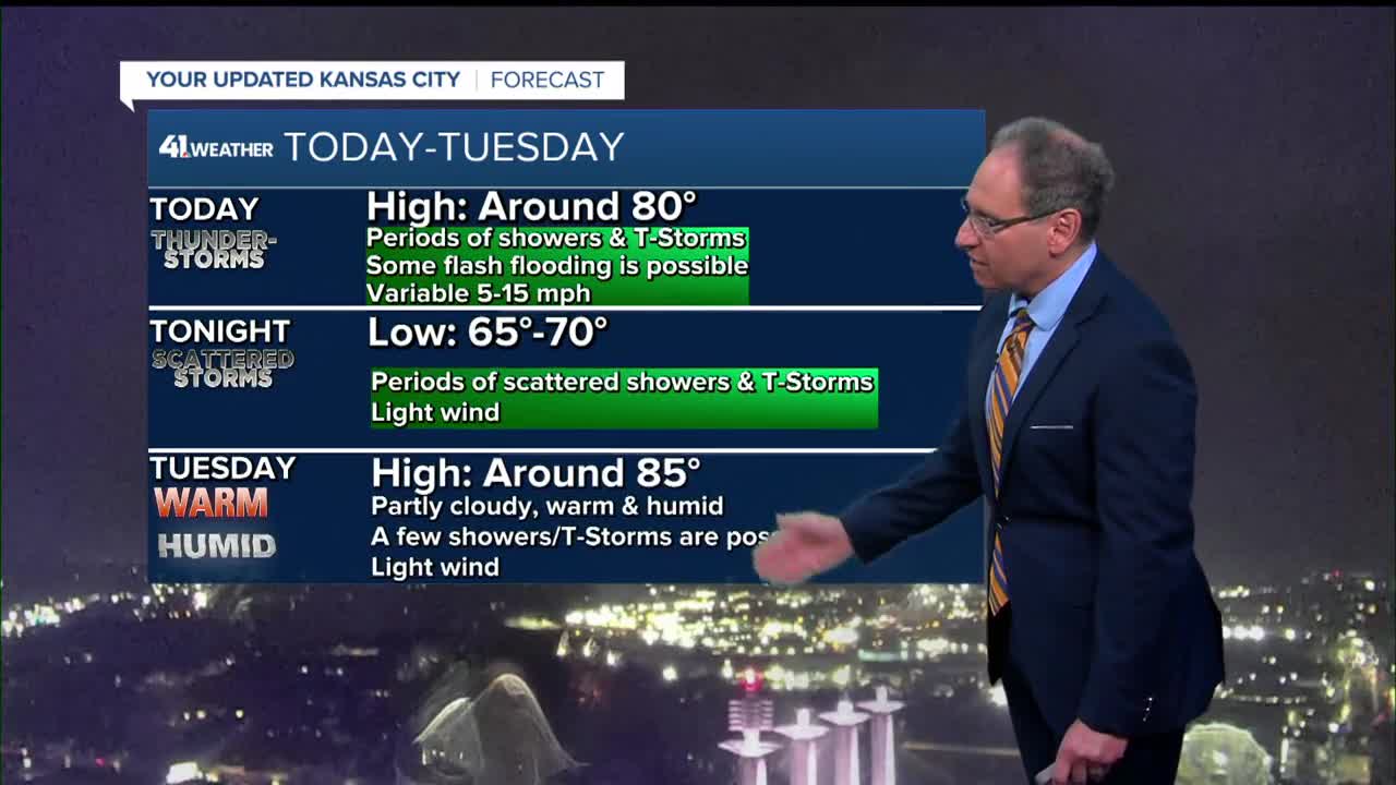
The high will be around 80° in our area, which is 10 degrees below average.

MONDAY NIGHT:
The second disturbance will move through, increasing the areas of showers and thunderstorms. We do not expect severe weather or major flash flooding.
But any very heavy thunderstorms can cause ponding of water on roads, which can cause hydroplaning. Hydroplaning is when water gets under the tires, causing the car to slide, similar to driving on ice.
Also, creeks can rise fast as well. Lows tonight will be 65°-70°.

TUESDAY:
We will see a few showers and thunderstorms linger as the Monday night disturbance tracks to northern Illinois. Highs will reach the mid-80s as we see more sunshine and moderate humidity.


WEDNESDAY:
Highs will climb to the mid and upper 80s as we see much more sunshine and barely any rain. The humidity will be moderate.
Thursday-Saturday will see the humidity get out of control as highs climb to 90°-95°. A new cold front with thunderstorm chances arrives next Sunday-Tuesday.

RAINFALL FORECAST TODAY-WEDNESDAY:
.10"-.50" is likely for most locations, with .50"-1" in some locations. There will be a few locations that see 1"-3".
Any heavy thunderstorm will have rainfall rates of 1"-2" per hour.

Officially, at KCI, which is the official reporting station for Kansas City, we are running about 2.50" above average on rain for the year.
Our wet summer will continue with more rain chances every 2-5 days the rest of August into September.

WEATHER FORECAST SUMMARY:

Have a great week ahead.
Stay healthy.
—
