


KANSAS CITY, Mo. — Good Thursday bloggers,
We are tracking a 2nd cold front, smoky haze, great weekend weather and a return of Summer after most thunderstorms with the 1st front set up southwest and south of Kansas City.
The 2nd cold front arrives later tonight, which will lead to great weekend weather. This is great news for the "Border War" in Columbia, Missouri, Saturday. The weather will be near perfect!
Let's go through all of this.
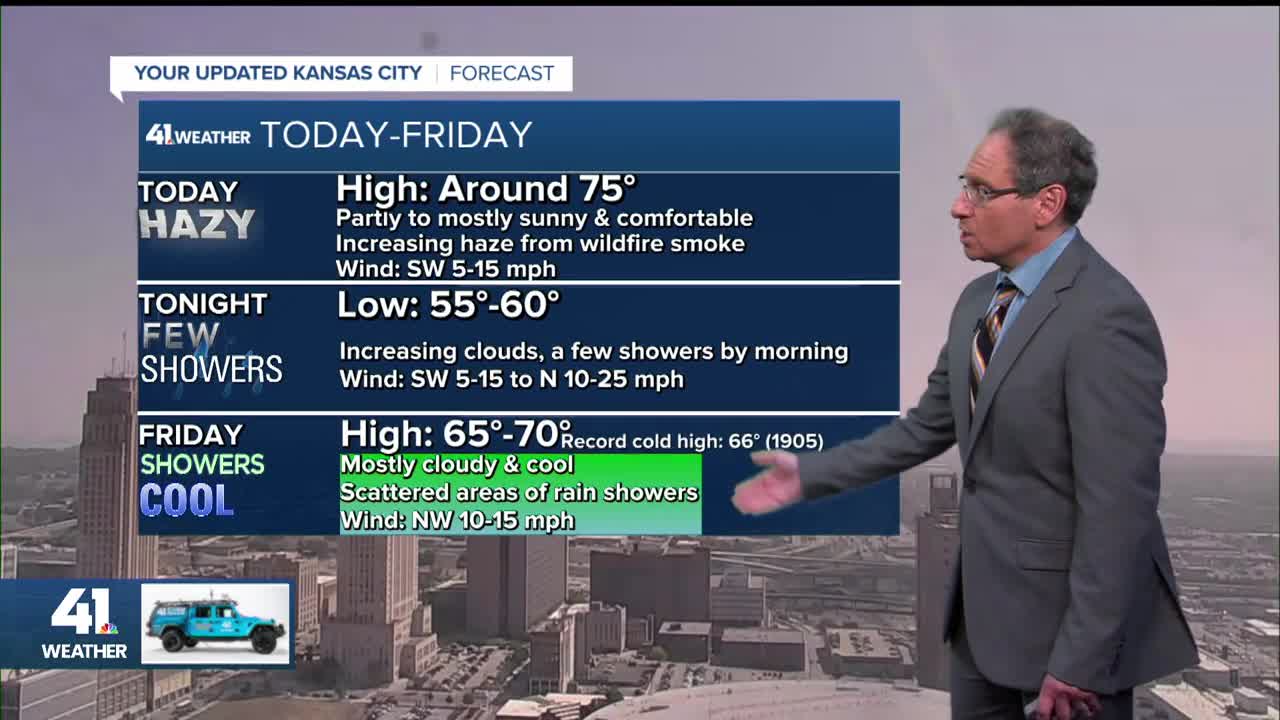
TODAY:
We are looking at some nice weather as highs climb back to the 70s. Now, you will notice a smoky haze as smoke from southwest Canada wildfires moves overhead. Some of the smoke may make it to the ground.

Here is a forecast for the smoke at 5:45 p.m. today. We are getting in to the dense/extreme category. So, keep this in mind if you are out and about. The smoke should thin out Friday-Saturday.

TONIGHT-FRIDAY:
A cold front will sweep through after midnight, bringing clouds and a few showers. Lows will be around 60°.

Then, during the day, a disturbance will track west to east behind the front in the cooler air.
It will generate areas of rain. In those areas of rain temperatures will be in the 50s! Temperatures will be in the 60s to near 70° where it is not raining. Highs will still be in the 60s in rain areas as it will not rain all day and/or the high may be at midnight.
The Interstate 70 corridor certainly has a chance for the band of rain, but confidence is low to moderate. If we see a high at KCI, the official reporting station for Kansas City, of 66° or lower, we will tie/break the record cold high temperature for the day set in 1905.
BTW, if we see rain Friday, amounts will be trace-.25", not much.

THE WEEKEND:
Regardless of how the rain plays out Friday, we are looking at great weather this weekend.
Saturday will see lows in the 40s and highs in the 70s with abundant sunshine and hopefully less smoke. This is great news for all of the outdoor activities, including the "Border War" in Columbia.


Sunday will see more nice weather with lows in the 40s and highs in the 70s. You can see a large surface high pressure over northeast Iowa, heading to the east. The wind around high pressure blows clockwise, so our wind will start shifting to the south and the warmer air to the south will start to head north.
You can see 60s and rain in western Kansas. These are showers/thunderstorms caused by the warmer air pushing out the colder air. Next Tuesday-Thursday, we have a chance to see some thunderstorm activity as the warm air returns.

Take a look at the change in the upper-level flow between today and next Friday.
The flow today is from northwest Canada, which is delivering our comfortable weather.

The upper level flow next Friday features a large upper level high also known as the "Heat Dome", anticyclone and "Heat Wave Creating Machine." Highs will make a run at 90° next weekend.

And, it is hard to believe, but football season is here. The Chiefs play in Brazil Friday night. Kickoff is at 7 PM (9 PM Sao Paulo time) and you can watch the game on KSHB 41.
The weather looks great with temperatures dropping from the 70s to 60s.

Have a great weekend
Stay healthy
GO CHIEFS!
