


Good Monday, blog readers —
Let's get right to it ... today is going to be a big severe weather day for the Great Plains.
The Storm Prediction Center (SPC) has issued a very rare Level 5 risk for south-central Kansas through central Oklahoma.
This high risk is because supercells will have the right ingredients to create long-track violent (EF2+) tornadoes in the zone between Wichita and Oklahoma City.
This will materialize into a line of severe storms for Kansas City by 8 p.m. Monday with destructive 70+mph winds and a few EF0-1 tornadoes possible.
The last time the SPC issued a Level 5 risk was 402 days ago.
The last level 5, High Risk day was March 31, 2023. March 31-April 1, 2023 was a widespread, deadly tornado outbreak ranking 3rd for producing the most tornadoes in a 24-hour period. 146 tornadoes touched down with 115 of those occurring on March 31, 2023. @KSHB41 pic.twitter.com/jZ7rkOzSBw
— ☀️ Cassie Wilson (@CassieKSHB) May 6, 2024
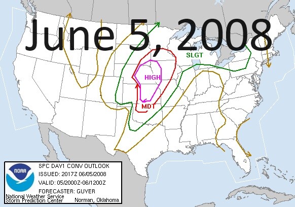
The last time the Kansas City area was included in a Level 5 threat was June 5, 2008. This was part of a multi-day outbreak June 3-11 that produced 192 tornadoes.
So while this could mean a tornado outbreak is brewing for our friends to our southwest, what does this mean for Kansas City?
Timeline
Thunderstorms are expected to develop ahead of the cold front through western Kansas with storms forming ahead of the dryline into the Texas panhandle and western Oklahoma by 2 p.m.
As we head toward the 4 p.m. hour, this will start to form a line. Anything outside of the line, anything with space, will have the potential to become supercellular.
The late afternoon and early evening is when we could see the "high-risk" area light up with tornadic activity.

Through northern Kansas, we have to overcome a little more inhibition, which is why the supercell violent tornado threat is staying south.

We are expecting clustering of storms to begin to for a line closer to 6-8 p.m. and begin to approach the Kansas City area. It looks like the metro impact will be closer to 10 p.m. as a line of storms will prompt concerns for QLCS (quasi-linear convective system, aka squall line) activity.

QLCS activity means EF0-1 tornadoes could quick spin up with winds 90-100 mph possible as this line moves through our area. We will also be watching for 70+ mph winds along the entire line, which can create enough damage on their own.

As we move through to 2 a.m., the severe threat will quickly fall apart. Keep in mind, the entire line will be capable of producing heavy rain, flash flooding, destructive winds and quarter-size hail.
Here's a look at what radar could look like by 2-3 a.m.

Please take some time today to prepare.
Talk to your family about your weather safety plan, and stay with KSHB 41 for all the latest updates.

—
