


KANSAS CITY, Mo. — Good Friday bloggers,
We are going to see a series of weather changes the next three days. We will be alternating between nice weather and unsettled weather. Before we go through these changes, let's look at the latest drought monitor. We are getting close to being 8" below average rainfall since July. This has allowed our area to be in severe drought, which is a level 3 of 5.
The severe drought is centered around Kansas City, with a moderate drought in most other locations.

Across the region, the drought is much worse in southern Missouri to northern Ohio. Kansas and Nebraska are doing pretty good.

Significant drought conditions cover almost half the USA, with the worst from Missouri to New England, parts of the southeast USA and west of the Continental Divide.

OK, let's go through the changes and look for rain.
TODAY (UNTIL 4 p.m.):
The first of two cold fronts will arrive this evening. Ahead of this front, we will have another day with temperatures 15-20 degrees above average, which means highs in the low 80s.

A few showers & T-Storms will be along the front from northeast Kansas to northern Iowa around 2 to 4 p.m. Our area will be partly cloudy, breezy and warm.

4PM TODAY through 5AM SATURDAY:
The first front will slowly move across our area, bringing areas of showers and T-Storms. Some T-Storms may contain hail & 20-40 mph wind gusts. Lows will drop to around 60°.


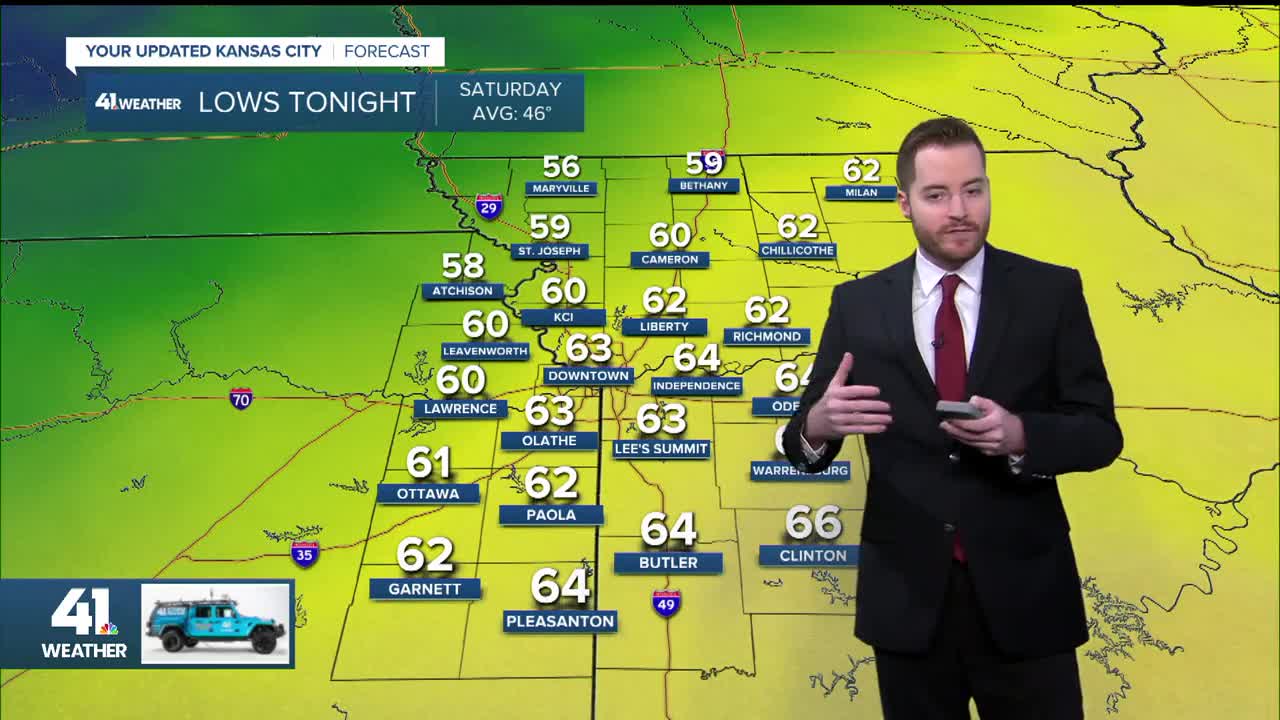
SATURDAY MORNING:
The rain will shift to the south between 5 a.m. and 7 a.m. as lows drop to the upper 50s and low 60s. This is good news for the Garmin Marathon.

SATURDAY (7 a.m. to 4 p.m.):
The first front will track into southern Missouri and weaken as the second front approaches from the northwest. Rain and T-Storms will increase along the first front as a system tracks in from the southwest, so highs there will be in the 60s. In between the two fronts, there will be a wedge of nice weather. It will be windy & cool with a few showers behind the second front.
Our area will be in the nice wedge. We will have to watch the rain/T-Storms to the south, as there is a chance that the rain/T-Storm activity could shift north closer to Kansas City.

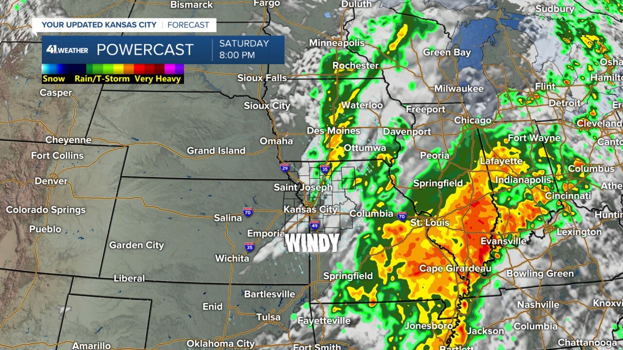
By 4 p.m., the second front will be on our doorstep with a few showers & windy conditions. You can see a large area of rain and T-Storms from eastern Oklahoma to Indiana. There is a chance this rain could track 100 miles farther north and get close to Kansas City, something to watch. Rain is needed everywhere, so wherever it tracks is good.

SATURDAY EVENING (4 PM-MIDNIGHT):
The second front will surge through and you will notice when it does. The wind will pick up from the northwest and increase to 15-35 mph along with a few showers and a temperature drop from the 60s to 50s. The big rain expands across southeast Missouri to Indiana. These are some very dry areas.
SUNDAY (MIDNIGHT-7 AM):
The wind, temperatures & clouds will decrease. Lows will drop to the 40s with a northwest wind 10-20 mph. It will be a bit chilly for tailgating.

SUNDAY (7 AM-4 PM):
We will see fantastic fall football weather with abundant sunshine and highs in the 60s with a northwest breeze 10-20 mph.

RAINFALL FORECAST (TODAY-SUNDAY):
The heaviest rain will occur from eastern Oklahoma to the Great Lakes, where 1"-4" rainfall amounts will be common. This is great news for those locations. Now, keep in mind, there could be a last-minute shift of this rain 50-100 miles farther north.
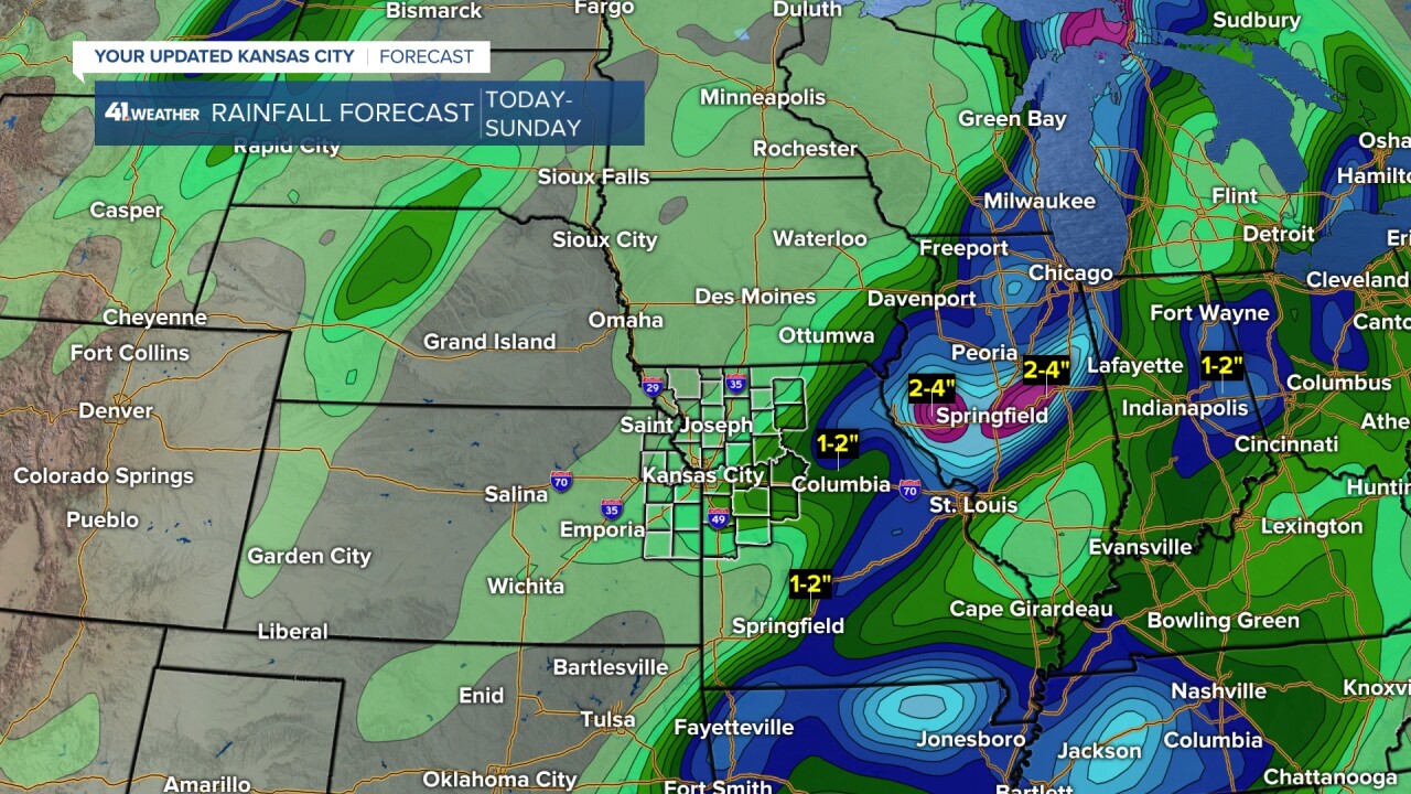
So, rainfall in our area will be in the .10"-.50" range. It is better than nothing. If the bigger area of rain to the south shifts north by 100 miles, then locations south of I-70 could see an additional .10"-.50".

WEEKEND WEATHER SUMMARY:
So, as of now it looks dry and nice for the Garmin race & Chiefs game. It will be chilly for tailgating.


Have a great weekend.
Stay healthy
GO CHIEFS!
