


KANSAS CITY, Mo. — Happy Thursday blog readers -
It's Friday eve and summer is in full swing! Today and tomorrow we hold onto the sunshine but by Friday night strong to severe storms are expected.

We've got two lows being ejected from the Rockies that will team up to bring rain and thunder across the northern Plains on Friday. The main threat for severe weather will stay into north west Kansas and southern Nebraska, but the Kansas City area is in a level 1 threat. Expect this to be a low end severe threat with mostly loud hit or miss thunderstorms.

Stormy Nights through the Weekend
A few showers could try and pop early in the evening, but these will stay light and will have minimal impact. It's really after 10 p.m. that the storm chances start to rise. We will start to see some scattered storm activity moving through the Kansas side first. These collection of thunderstorms will start to organize as a larger system called as MCS (Mesoscale Convective System).

MCS's tend to favor the 10 p.m. - 2 a.m. time frame for initialization. So by 1 a.m. we could be dealing with a more organized storm that could produce strong to gusty winds.

The storm threat looks to fall off quickly before sunrise and I don't love holding onto a lot of rain Saturday morning. But Saturday could remain unsettled and kind of cloudy at times. But overall I think much of Saturday should remain dry. Saturday night some trailing post frontal showers are possible. This should develop around Interstate 70 and drift south Saturday overnight into early Sunday.

If you are heading to Pride Fest this weekend, or any other events around town this weekend, know that much of the daylight hours should be dry.

Next Week
This week we saw a ridge of high pressure build in the desert southwest, but next week that head dome looks to try and make it's way to Kansas City.

So could we be talking about our 1st 90° day??? Remember the average date to hit 90 in Kansas City is May 27, and the longest we've ever waited was July 15, 1904. The last time we had to wait until July to see 90° heat was 2004 and last year we hit our first 90 on May 6. So we are watching June 13-15 as our window to kicking off the 90s this year.

Summer 2024
As we wrap up spring 2024 and move into the summer season here's where we are from a climate perspective. Spring 2024 was the 12th warmest spring in Kansas City history and that comes on the heels of the 7th warmest winter. So while we may be hitting our 90° day late, I don't think that is an omen that this summer will be mild. The more interesting note here is that this Spring while near normal for precipitation was abnormal in regard to severe storms. We saw 24 tornadoes reported in our area. The normal average in a year around here is 10. So we stayed stormy and didn't give ourselves a real window to heat up to 90° this spring.
We've kicked off Meteorological Summer! Spring 2024 wrapped up as the 12th warmest in KC, on the heals of the 7th warmest winter, so no surprise we are already warm! Did you know we average 2" of snow during Spring? Missing that little bit put us in 4th place for low snow @KSHB41 pic.twitter.com/MOsnSlPdhI
— ☀️ Cassie Wilson (@CassieKSHB) June 4, 2024
We are expecting the summer to be above average for temperatures, yet again. When we look at the summer season, our climate normal is 76.3° for the mean average temperature. We haven't seen a summer register below that average since 2017.
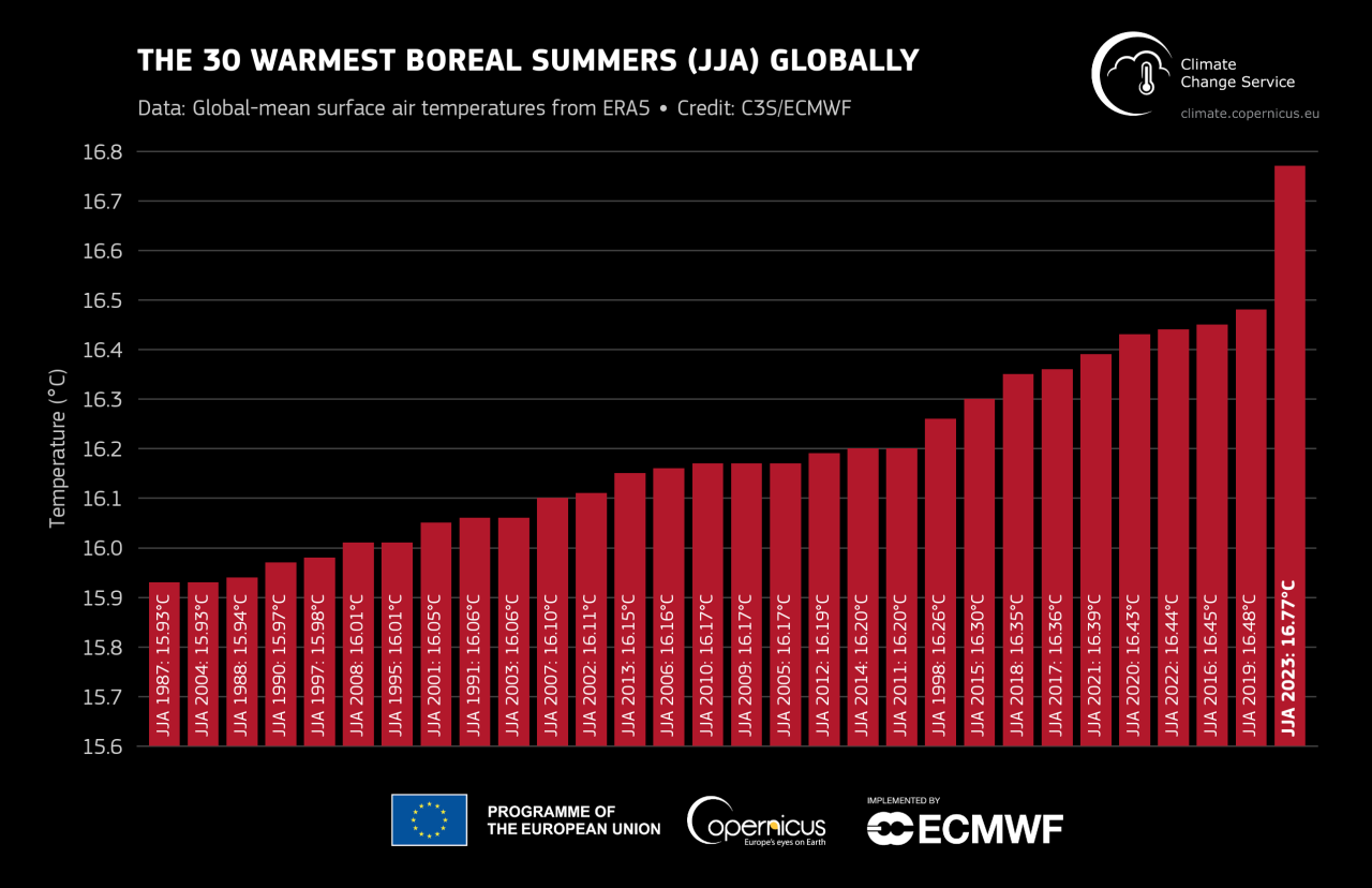
Climate change is influencing summer heat globally. Out of the top 10 hottest summers globally, nine of those years have occurred in the last decade.
So it's kind of a no-brainer Summer will be warmer than normal. As we look at ENSO the ocean index is neutral so there isn't a big forcing within the ocean-atmosphere feedback loop. I will say that could change by the Fall, as we are expecting La Nina to take over. The good news about this summer, we shouldn't have a tendency for drought. We have recovered from the drought in the Kansas City area and we should stay in the positive despite any heat this summer!
