


KANSAS CITY, Mo. — Good Thursday bloggers,
We are in for two more days of unseasonably warm air before long-overdue fall changes arrive. Let's go through the changes we will see in temperatures and rainfall.
Before we get to the details, let's look at the upper-level flow, which dictates what occurs at the surface.
UPPER LEVEL FLOW TODAY:
We are right on the axis of the ridge/upper level high, which means sunshine and unseasonably warm temperatures. There is a storm system, opposite of an upper-level high, over Wyoming.

UPPER LEVEL FLOW FRIDAY:
The pattern becomes more complex as the upper-level ridge/high retreats to the south and the main storm from Wyoming tracks into southern Canada.
The main storm leaves a small upper-level low in the southwest USA as a new batch of energy streams into the Pacific Northwest and western Canada. The main upper low in Canada will drag the first cold front into our area as it waits for the new energy and a second cold front.

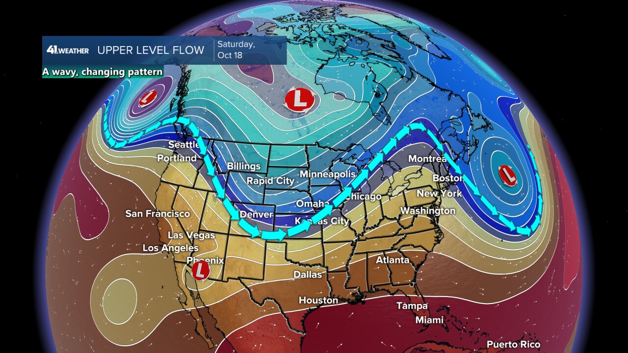
UPPER LEVEL FLOW SATURDAY:
The new energy and system from the southwest combine into a big trough. This trough, the opposite of a ridge, will be moving through the middle of the USA, bringing the 2nd cold front.
The pattern is becoming wavy, which means a series of systems are likely into next week. This does not mean a lot of rain, but it means up and down temperatures and an end to the unseasonably warm air.
Now, let's see what the upper-level flow means at the surface.
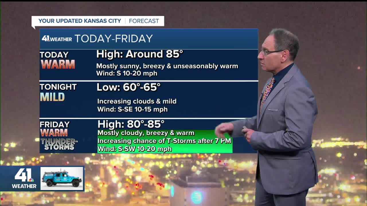
TODAY:
It will be another day where highs are 15-20 degrees above average, which means highs in the 80s. The 1st cold front will be entering the western Plains, where scattered thunderstorms are possible.

FRIDAY:
It will be breezy and unseasonably warm again under a mostly cloudy sky. The 1st cold front will be getting closer into central Kansas. Scattered T-Storms will form on this front.

By noon, you can see a few showers and thunderstorms from central Kansas to western Wisconsin.

Friday evening and night will see the front light up with scattered thunderstorms. The best chance to see any rain in KC will be between 7 p.m. and midnight.

SATURDAY (MIDNIGHT-7 AM):
The line will shift to the south, extending from northeast Oklahoma to Michigan.

SATURDAY (7 AM-7 PM):
The first front tracks into central Missouri and starts to fall apart as the second front surges in from the northwest as the small system in the southwest races northeast to meet the 2nd front.
Highs will be in the 70s with a light wind as we wait for the second front.

Right now, it looks like the second front and system will get their act together about 100-200 miles to the south and east. We may see a few showers and thunderstorms Saturday, but most likely will miss the main rain.
Saturday night will be windy and cool as the second front moves away. Lows will drop to the 40s with a northwest wind 15-30 mph.

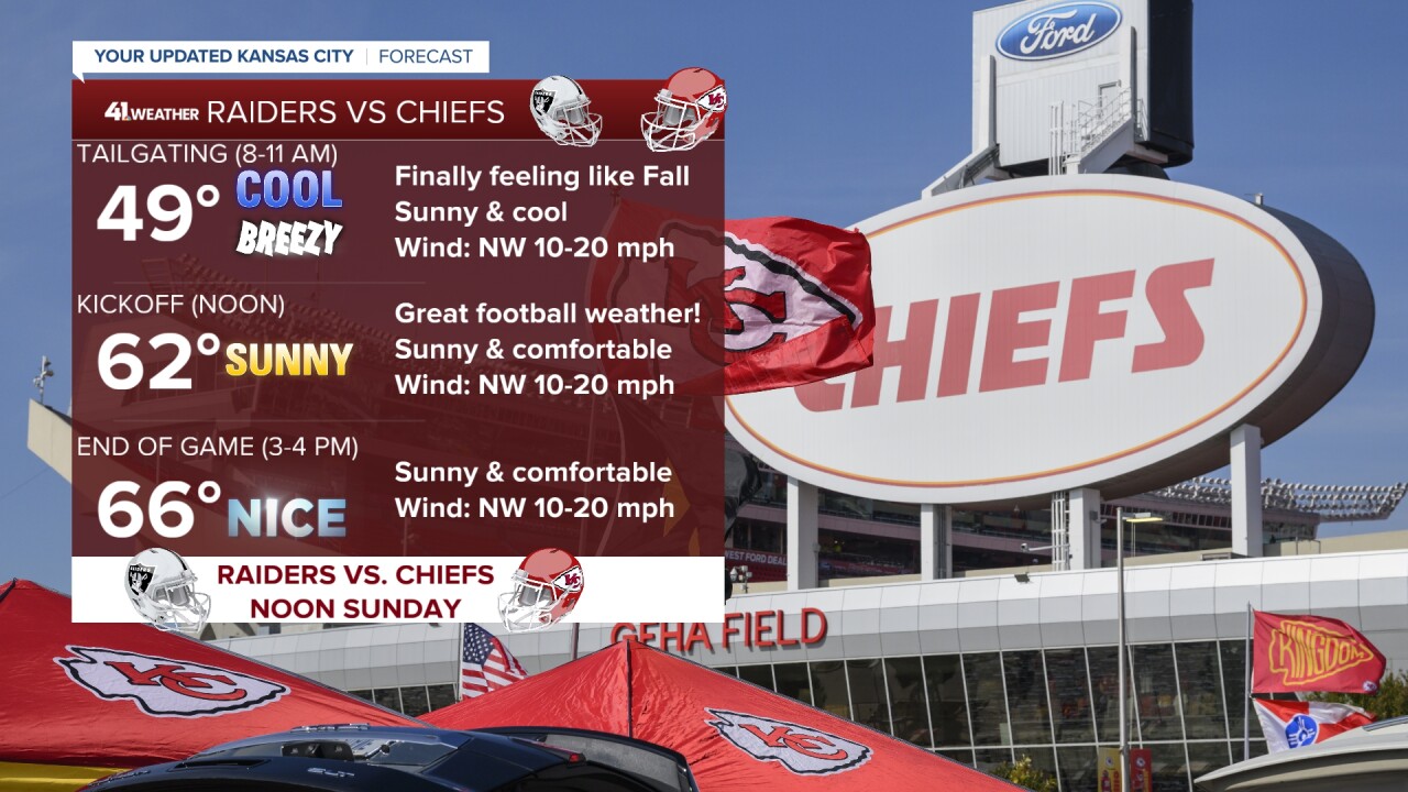
CHIEFS SUNDAY:
The rain will be long gone regardless of how the details of the system and fronts set up.

It will be sunny and fall-like with highs in the 60s, along with a northwest breeze at 10-20 mph, great football weather.

The Chiefs game on Sunday is a rare noon kickoff, so for tailgating, it will be breezy and cool as temperatures warm from the 40s to low 50s.
RAINFALL FORECAST FRIDAY-SUNDAY:
Ok, I have waited to the end for the rainfall forecast because there is once again a trend to seeing less rain.
Right now it looks like the heaviest, 1"-4" of rain, will occur from northeast Oklahoma to the Great Lakes.

Our area will likely see .10"-.50" or less. Northwest Missouri may not see much rain at all. Now, could this change and the heavier rain shift 100-200 miles north? Yes, it can, but the chance is low. It will require the southwest system to interact with the second front faster. We will see what it looks like tomorrow.

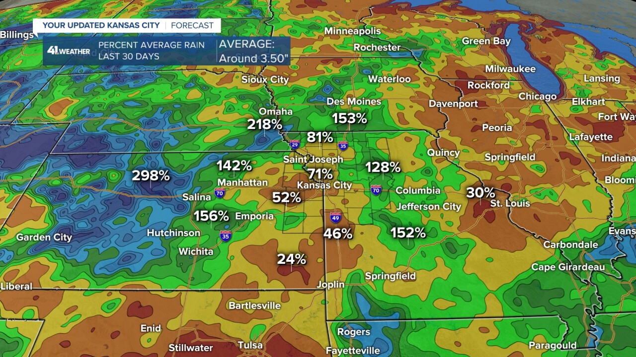
The percent average rainfall during the last 30 days is lowest in far eastern Kansas and western Missouri. Rainfall has been 25% to 70% of average. Locations surrounding the dry areas have seen decent rain with percent average over 150%. Average rainfall for the last 30 days is about 3.50".
Have a great weekend
Stay healthy
