


KANSAS CITY, Mo. — Good Friday bloggers,
We are looking at some fall like changes after the Chiefs game. It seems appropriate as we begin the college football season and we are two weeks from the NFL season.
The weather looks great for football from Kansas to Ireland.
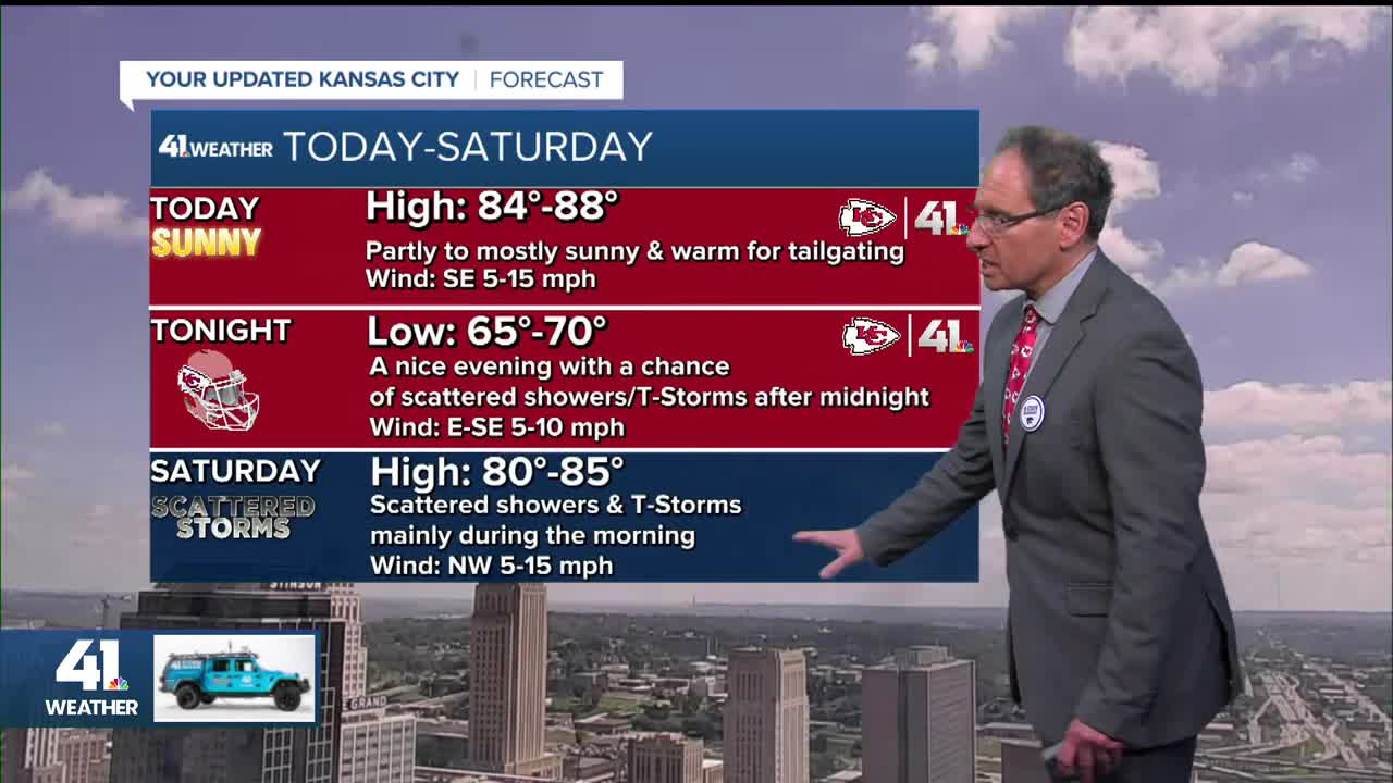
CHIEFS (KICKOFF 7:20 p.m. ON KSHB 41):
It will be warm and dry for tailgating, warm to mild and dry for the game followed by a chance of scattered thunderstorms after midnight.

K-STATE (KICKOFF SATURDAY AT 11 a.m. CT; 5 p.m. DUBLIN TIME):
The game kicks off at 11 a.m. Saturday (Manhattan, Kansas, time, which is 5 p.m. in Dublin, Ireland). The weather looks dry with temperatures basically in the 50s and 60s. There will be a lot of clouds, with little to no rain. However, you can't rule out a shower or some drizzle.

KU (KICKOFF 5:30 p.m. IN LAWRENCE):
There may be a few showers/t-Storms until kickoff. Then, the weather looks great as temperatures drop through the 70s with a light north-northwest breeze.

————————————————————————————————————————————————
Now let's take a look at the weather changes this weekend.
TODAY:
We will see a lot of sunshine with highs in the mid to upper 80s after a cloudless sunrise. There was some fog along creeks and rivers, but that will burn off fast.


The last of the summer high heat will surge into southeast Nebraska, north and northeast Kansas and northwest Missouri ahead of a strong summer cold front. It looks like the high heat will stay just northwest of Kansas City.
The cold front will be tracking south through Nebraska, generating scattered thunderstorms.

TONIGHT:
It will be dry until 3-5 a.m. as we see areas of showers and thunderstorms increase across Nebraska and Iowa. They will head southeast as they form. But, they will not reach Kansas City until 3 to 5 a.m. There is a slight chance they get here by midnight to 1 a.m. Regardless, the rain will hold off until after the game.


SATURDAY MORNING:
This when we have the best chance to see rain and thunderstorms this weekend. If this data is right, all locations will see .10"-.50" with some locations seeing .50"-1". However, there is still a question on how widespread the rain becomes. So, as of this moment, we feel some areas will see .25"-1" while others see nothing. We do not expect these to be severe.

SATURDAY AFTERNOON:
A few showers and thunderstorms may linger. So, where there are lingering showers and thunderstorms, highs will be in the 70s. Where there is sunshine, highs will reach 80°-85° as the front pushes the heat south.

SATURDAY NIGHT-SUNDAY MORNING:
A surface high pressure will be located over Iowa, bringing our area a cool northeast breeze at 5-15 mph. Lows will be 55°-60° around here and in the 40s to near 50° in Iowa. Any thunderstorms will be found in southwest Kansas to southern Missouri.
The weather looks good for the Head for the Cure race out at Corporate Woods.

SUNDAY AFTERNOON:
Highs will be in the 70s to around 80 under a partly cloudy sky. Thunderstorms will be found across south and west Kansas to southern Missouri, where the cold front is stalled.

Have a great weekend
Stay healthy
