
Good morning bloggers,
A rather fascinating weather pattern is set up across the United States and all of North America. A blocked up weather pattern has developed. This is the second time in this year's cycling pattern, the LRC pattern, that the pattern has been blocked this significantly. The first time a strong block developed in February, we had the major Arctic Air outbreak that dropped our temperatures to -23° in Garnett, KS, and -16° in KC. Thank goodness we are moving into mid-April, as it will not be that cold, quite obviously, but we may see some frosty mornings. Let's look at the flow around 18,000 feet up above us:
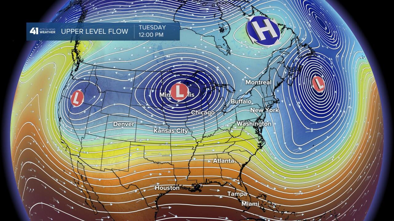
Look at the trio of upper level lows. The farthest west one will be our next weather maker in Kansas City later this week. The block is seen where that H is plotted. That is an upper level high height area. If you look closely, you can see the northern stream and the southern streams of the Jet Stream. North of the title banner is the northern stream up across northern Canada, and the southern stream is across Mexico and the southern United States. The block is helping separate the streams. This block is like a big boulder in the river of air that affects the pattern, but the river continues to flow and cycle according to the LRC. This block will break down within a week or so, but this cool pattern will likely last a few days longer.

By Friday, the western upper low, in the trio of lows shown in the first map, will be moving out into the plains. There are still a lot of questions about this system, on how strong it will be and where it will track. This upper low, forecast to be near Garden City, KS, may weaken rapidly.

That western upper level low will be weakening and zipping out our way by Friday. This will increase the chance of rain to nearly 100%, and I will likely up our probability to 100% on Friday. This storm will also produce a good chance of snow over western Kansas and a few snowflakes may make it into central and southern Kansas.

Kansas City Weather Time-Line:
- Today: Mostly sunny with a few periods of clouds. Light winds. High: 61°
- Tonight: Frost is possible between 6 AM and 8 AM. it will be clear with light winds. Low; 36°
- Wednesday: Partly cloudy and a bit windier. The wind will increase from the north at 10-20 mph. High: 58°
- Wednesday night: Frost likely and a chance of a light freeze. Low: 33°
- Thursday: Increasing clouds. Light easterly winds. High: 60°
- Friday: Cloudy with a 100% chance of rain. High: 49°

Come on out and meet our team. Rainbow & Sunny The Weather Dogs will show off their tricks too! We will be on stage before noon and we hope to see you there this Saturday!
Thank you for spending a few minutes of your day reading today's blog. Have a terrific Tuesday.
Gary