

Good morning bloggers,
We will look ahead to a few severe weather risks that are in the LRC forecast in just a second. Let's begin with a look at what just happened and how yesterday's snow put us up to a rather magical seasonal total. 3.5" of snow accumulated at KCI Airport yesterday. This 3.5" is a record for the date, and much more significantly it is the largest snowfall for so late in the season. Kansas City has never had more than 2.7" of snow after April 20th, so this smashes that record, one that likely will not be broken again in our lifetime.

For the second straight year it appeared our last snow would happen in February, as we had no snow in March the past two winters. Our weather team was watching closely as I knew we needed exactly 3.5" of snow to have my own snow prediction be hit. The 3.5" of snow puts our final snowfall total at 15.5" for the season, and it lands as a perfect bulls eye on my own prediction:


While I used knowledge of the LRC to make this spot on prediction, our weather team did quite well. Everyone is within 3.5" in our predictions.
The weather pattern is cycling and this storm was right on schedule, per the LRC. 184 days before yesterday there was a Snow Squall Warning for Iowa where 6 to 9 inches of snow fell in this part of the pattern in October. Kansas City also had snow in October on October 26th when over an inch fell on the Plaza and 0.9" fell at KCI Airport. So, snow in October, and snow in April, and now NO MORE SNOW. That was our last snow and there is no more in sight.
In our spring weather special and in the LRC spring forecast we discussed the signature part of this years cycling pattern. And, I made a prediction that this part of the pattern would return between April 27th and May 4th:

I called it the "Jefferson County, Alabama Tornado" part of the LRC becuase a tornado has happened in the last three previous LRC cycles in Jefferson County, Alabama. This is the Birmingham, AL area and they may be targeted once again in the next two weeks. As summer approaches, the jet stream is retreating northward, which will result in the same pattern suddenly producing severe weather risks closer to KC. We have not had a Tornado Watch in Kansas City in almost two years (May 28, 2019 is our last Tornado Watch). We will be monitoring this shift in the weather pattern closely.
Here is a look at two possible severe weather risks from April 27th and May 1st. These are from the GFS model, and it will look a bit different. These are definitely severe weather risks, and it may include our region.
April 27th Set Up:
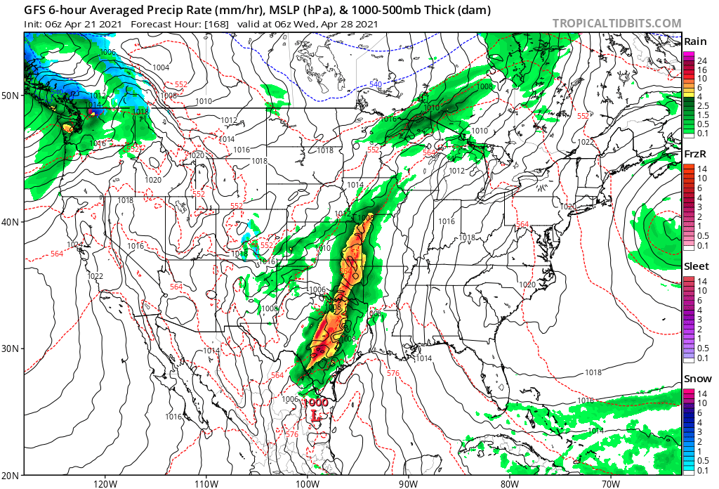
So, what does this map show above? Right on schedule there is a storm forecast to develop over the southern plains states early next week right on April 27th. It appears the risks of severe weather may stay south of KC once again.
A few days later we have this set-up on May 1st below.
May 1st Set-Up:

This is a looking impressive for a possible significant severe weather set-up. KC would be on the western edge of this one. The bottom line is that we have a part of the LRC cycling through and we can start preparing for it now. I will discuss this developing pattern on 41 Action News.
A big warming trend will happen ahead of this next part of the LRC. And, we are forecasting near 80 degrees by Monday and Tuesday. But before we get to that warm up there is another system heading our way as early as tomorrow. A band of rain, with possibly a few weak thunderstorms, will be developing tomorrow as you can see below. This map is valid at 1 AM tomorrow night, so the chance of rain arrives later in the day tomorrow into the evening.

Thank you for spending a few minutes of your day reading the Gabbing With Gary blog. Have a great Wednesday.
Gary
