

Good morning bloggers,
The "Heat Wave Creating Machine", or anticyclone, is centered near the Red River Valley on the Oklahoma/Texas border today. The main jet stream is about to shift south, but today it is still near the USA/Canada border. These features have created the conditions for another record breaking hot day.

Hurricane Fiona continues to strengthen and it has become the first major hurricane of the season this morning. It is near Turks & Caicos and they are experiencing the wrath of this storm. It is only the sixth named tropical storm of the season and fortunately it is heading north over the open Atlantic Ocean later today and staying way east of the United States.

Back home, here in Kansas City, we will likely set a record for the third day in a row. Here are the records for this three day stretch:
- Sunday, September 18, 2022: We tied the record high of 96° set in 1925
- Monday, September 19, 2022: We broke the record high of 95° set in 1954 by four degrees. It was 99° yesterday
- Today, September 20, 2022: The record high is 95° set in 1948. Our forecast is for it to get close to 100°
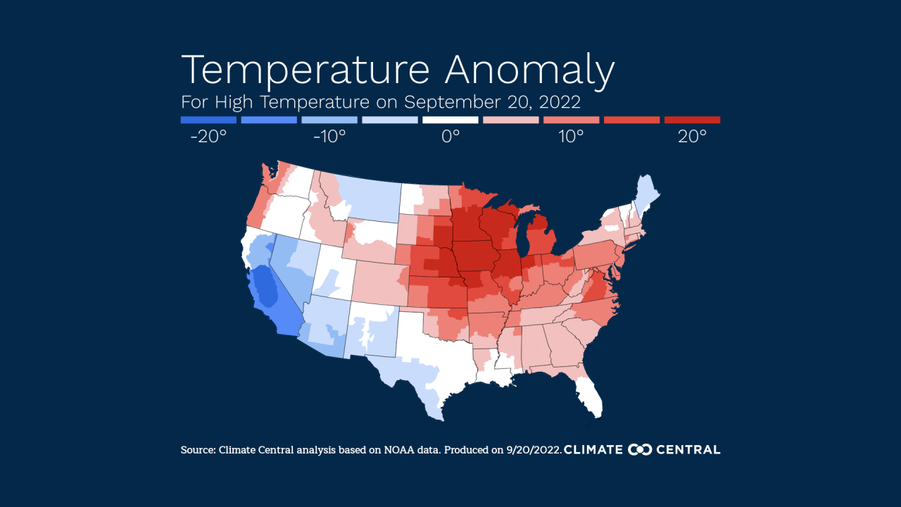
Climate Central shared this graphic with us showing the way above average temperatures from Minnesota south to KC today:
They also are showing that this heat over Minnesota and Wisconsin is extreme. The Climate Shift Index is a level 4 as shown below:
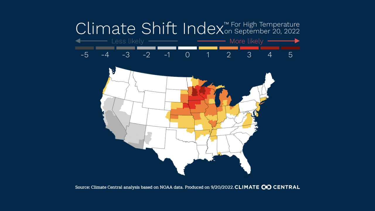
Climate Central suggests that "climate change has made the conditions at least 4x more common. These conditions would be extremely rare without climate change". Here in Kansas City it is a level 2.
It has only been 100° after this date twice in our Kansas City recorded history. On September 22, 1937 it reached 100° and on September 28, 1953 it reached 103°, the latest 100°+ ever recorded. Let's see how high it goes today.
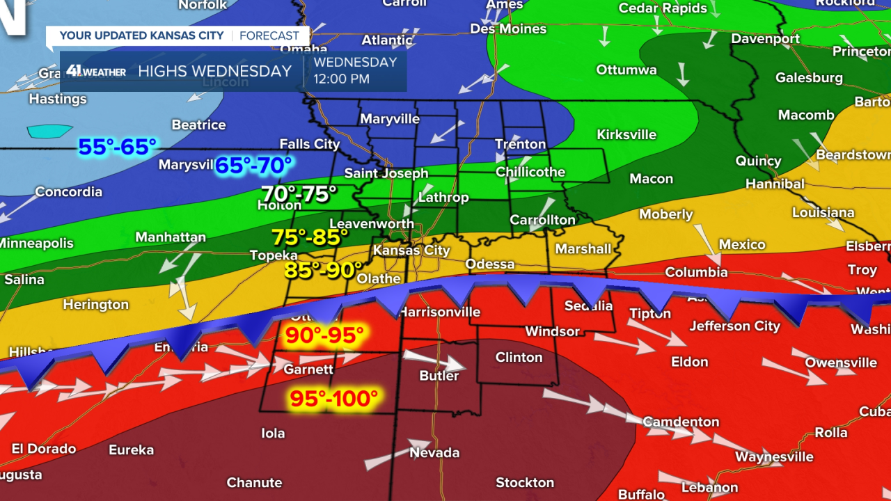
A cold front is on the way, and by noon tomorrow it will be passing through Kansas City with the wind increasing from the north:
It has been extremely dry since the beginning of July. Kansas City is over 6" of rain below average since July 1. We will get the temperature drop, but will it rain?
It is getting frustrating to come up with reason after reason why we keep missing these rain chances. September is usually a wet month. We will test this again as this cold front moves through Wednesday.

There are usually strong thunderstorms along fronts like these at this time of the year. We have what is called "the second season" of severe weather season in the fall from around mid-September to mid-October. But, this front appears it will zip by dry with just a slight chance of a thunderstorm.
The chance of rain will increase later Wednesday night into early Thursday, but as you can see below the rain appears it will zip by and be fairly light.

If we see any increasing chance that the rain will be more organized, we will certainly update this forecast. For now, it looks like any rainfall amounts near KC will again by fairly light and under 1/2".
Thank you for sharing in this weather experience and spending a few minutes of your day reading the weather blog. The new LRC will begin evolving in the next two weeks as the sun is setting at the North Pole Thursday, so different things will begin happening around the Northern Hemisphere. I just wish one difference would be some rain with this cold front.
Have a terrific Tuesday,
Gary
