


Good morning bloggers,
We hope you enjoyed our spring special Surviving The Storm last night. If you missed it, you can get the links to the segments on KSHB.com, and it airs again on Saturday at noon. So, set your DVR. In the Severe Weather Special we discussed the severe weather dates with the signature part of the pattern due in around April 27 to May 4. Today is another part of the pattern that has produced in previous LRC cycles. In fact, right before Christmas there was a two-day severe weather event that produced 25 tornadoes in the south. This year's cycle is 46 days, and today is 90 days after that event, or just about right on schedule per the LRC. Look at the risk today:

An outbreak of severe thunderstorms is possible with long track tornadoes and strong tornadoes possible in this region later this afternoon. The same storm producing this set up is producing rain in KC this morning:
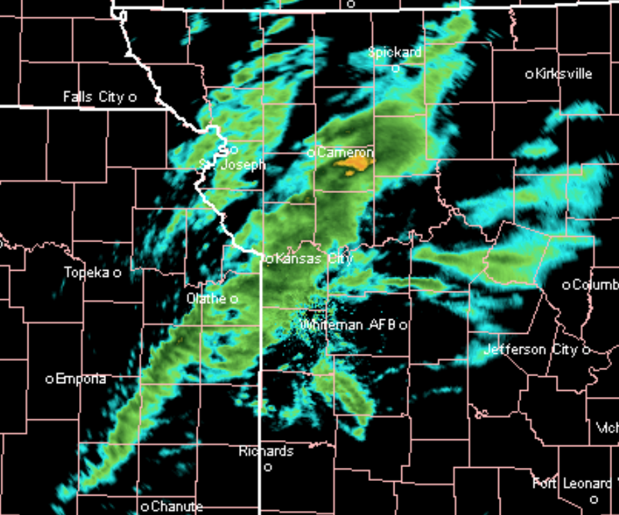
Expect rain off and on near that I-35 corridor into this afternoon, and then this storm will move away.
SPRING FORECAST:
The weather pattern is cycling according to the Lezak Recurring Cycle (LRC). The LRC describes the river of air flowing above us around 10,000 to 25,000 feet above us. It is really a big atmospheric puzzle and we use this proven method to help guide us through these accurate weather predictions that go out as long as 300 days ahead of time.

The LRC, which was named by the weather bloggers back in 2002, allows us to "know" what the weather pattern will look like. For example, we predicted that there would be a tornado in Jefferson county, Alabama, around the middle of March 50 days earlier in our weather blog. Last week, Jefferson county, Alabama, had multiple tornado warnings last week and one tornado. That's important for many reasons, and for Kansas City, the part of the pattern that produced that severe weather outbreak in Alabama on March 17 will be cycling back across the United States two more times this spring as you can see below:

That signature part of the cycling weather pattern will cycle through during the last few days of April into the first week of May. There is an eight-day range in there for this part of the pattern because there are three to four storm systems in a series that will cycle across producing multiple chances of severe weather. Kansas City may be a target in one or two of these storm systems, in just this part of the pattern.
There are other parts of this pattern that we are monitoring closely as well. Kansas City has not been under a Tornado Watch in almost two years. Yes, there was a tornado a week ago in southern Johnson county, and there was a Tornado Warning, but there was no watch in effect. A Tornado Watch is issued for large areas when conditions are coming together for severe thunderstorms that may produce tornadoes. The conditions have not been coming together in our area since May 28, 2019 when we had the Linwood, Kansas tornado just southwest of Kansas City. We will likely have a few Tornado Watches this spring.
There is enough activity and the evidence is there with this year's LRC for us to confidently predict you won't need your sprinklers too often until summer. Here is our rainfall and temperature forecasts for the spring months of April-May-June:
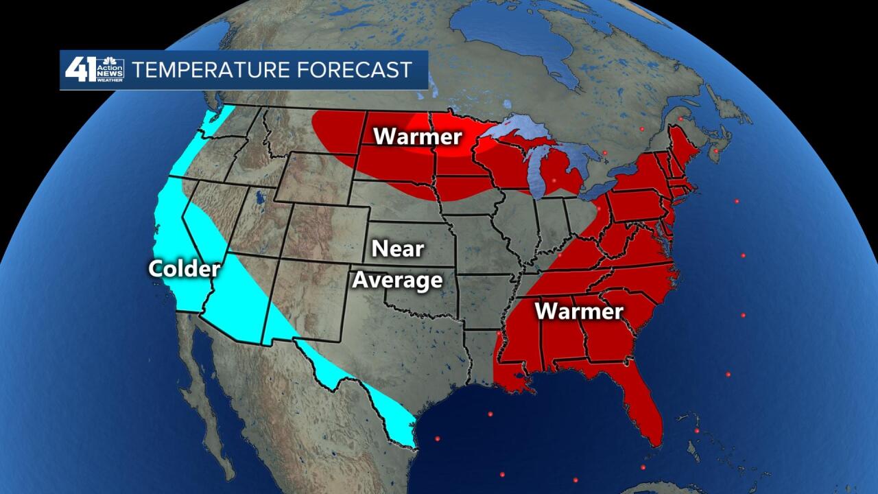

Kansas City averages just over 14 inches of rain during these next three months. We are forecasting near to above average rainfall this spring.
Here is our specific forecast:

We are recommending families to have a plan and practice that plan. If a Tornado Warning is issued for your area, our weather team will be springing into action and provide you with the most calming, informative, and accurate information to help you get through each threat. It has been a couple of years since a real serious risk has presented itself. This pattern is going to produce a few set ups for severe thunderstorms. For the kids, and those of you concerned, remember the chance of you seeing a tornado, not to mention get hit by one is extremely low. Meteorologist Jeff Penner has lived here for 50 years and has yet to see his first tornado, and that even includes a few storm chases. So, they are rare.
We have a great team of 41 Action News Storm Chasers and our weather team will be ready. We are hoping you will be prepared with your own plan as well. Stay with 41 Action News, and we'll keep you advised.
