

Good morning bloggers,
A cold front moved through around midnight last night. This is a Pacific cold front and not an Arctic cold front, and all it has done is drop us to near seasonal averages. The average high is 46 degrees today! The front has moved into southeastern Missouri as you can see here:

This is a Pacific cold front. What I mean is that the air mass originated over the northern Pacific Ocean, and did not really tap the coldest air that has shifted north over Canada. This means that the temperature drop will not be as extreme!
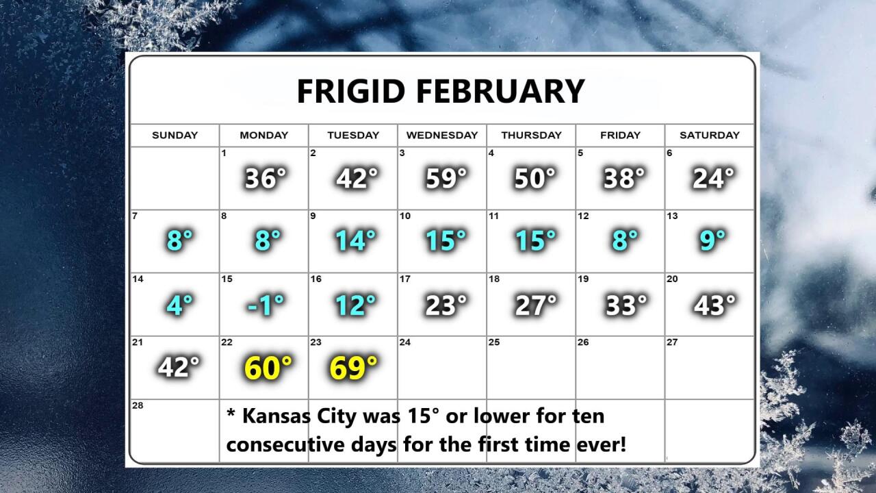
The temperature fell just short of 70 degrees yesterday with the official temperature coming in at 69°. In the sun it was near 80° which is 115° warmer than how it felt seven days earlier with a wind chill of -35°. Here is the February High Temperature Calendar showing the wild weather ride:
The weather pattern has been putting us on this roller-coaster ride of temperatures. We discussed the LRC in yesterday's blog, and the pattern is cycling right on schedule. Kansas City did not get hit by any major winter storm all winter long despite changes in other parameters such as the Arctic Oscillation (AO). The AO has just flipped from a deep negative phase to a positive phase. Take a look:

The AO had dipped deep negative, lower than it has gone in nearly a decade. This dip happened around seven to ten days ago, and it manifested in the blocking pattern over northern Canada and the Northern Hemisphere. This directly lead to the conditions that blasted us with the Arctic air and a dip to 13 degrees below zero. The AO has now flipped phases and is positive. And, this has resulted in our warmer temperatures. Another warm up is heading our way with a surge to near 60 degrees again on Saturday.

The rainfall forecast for the next 15 days is from the most recent American Model (The GFS model). It does show KC with around 1/2" of rain. We are on the edge, however. We will be monitoring the pattern closely, but for now, it will be dry for the next few days.
The forecast for today is for mostly sunny and a northwest breeze around 15 mph. The high will be around 48° this afternoon.
Thank you for spending a few minutes of your day reading the Gabbing With Gary blog. We will update the forecast on 41 Action News today and tonight. Have a great Wednesday.
Gary
