


Good morning bloggers,
The weather pattern is changing gradually right now. Something unusual happened last month over Greenland. From The National Snow & Ice Data Center: "On August 14, 2021, rain was observed at the highest point on the Greenland Ice Sheet for several hours, and air temperatures remained above freezing for about nine hours. This was the third time in less than a decade, and the latest date in the year on record, that the National Science Foundation’s Summit Station had above-freezing temperatures and wet snow. There is no previous report of rainfall at this location (72.58°N 38.46°W), which reaches 3,216 meters (10,551 feet) in elevation. Earlier melt events in the instrumental record occurred in 1995, 2012, and 2019; prior to those events, melting is inferred from ice cores to have been absent since an event in the late 1800s. The cause of the melting event that took place from August 14 to 16, 2021, was similar to the events that occurred this late July, where a strong low pressure center over Baffin Island and high air pressure southeast of Greenland conspired to push warm air and moisture rapidly from the south."
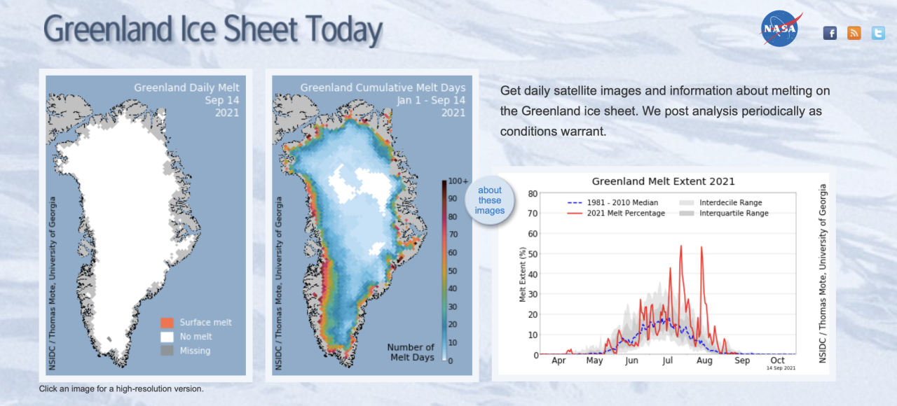
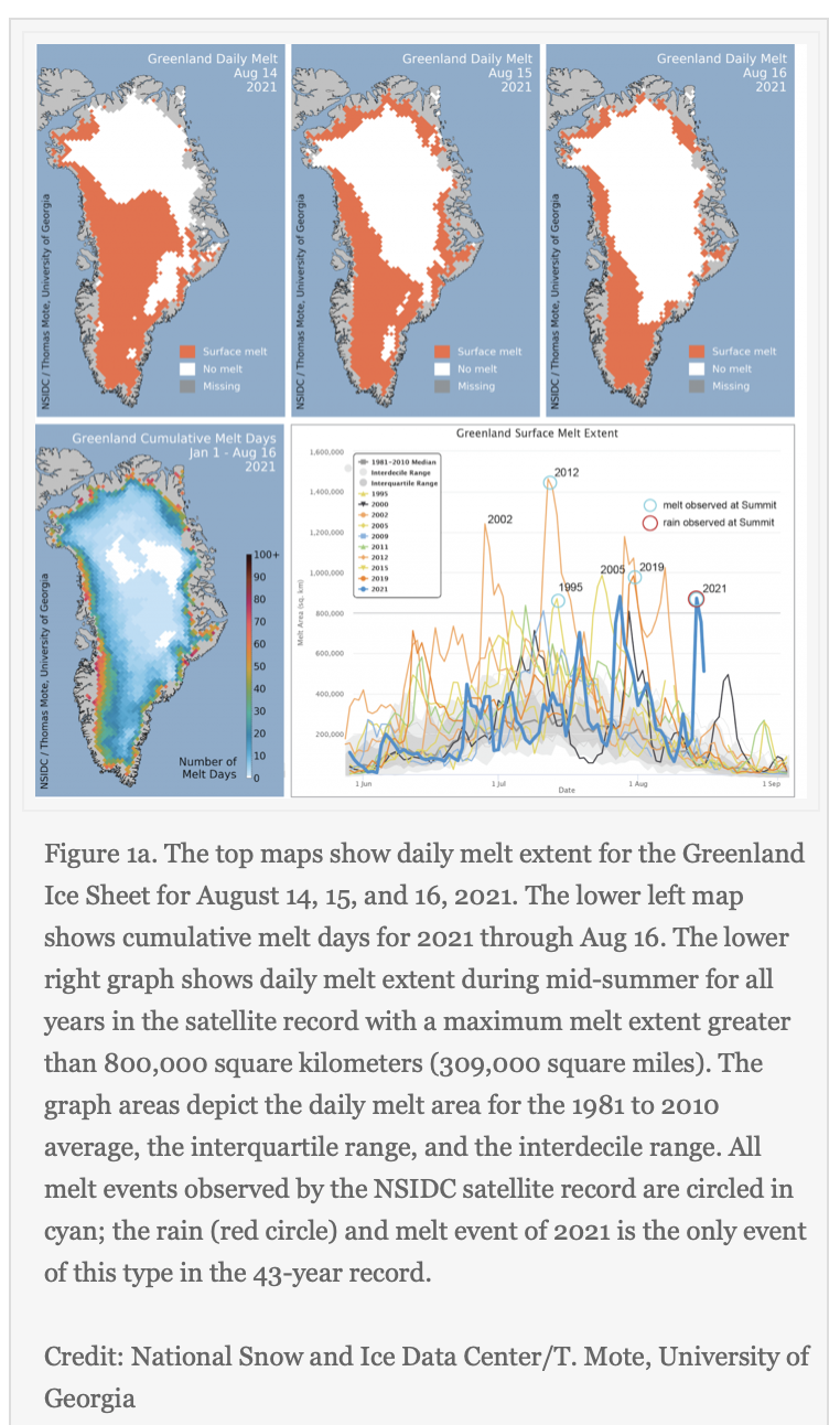
"Widespread surface melting and an extensive rainfall event along the southeast coast extending up to the Summit region of Greenland occurred on August 14 and 15, with melt area returning to moderate levels on August 16 (Figure 1a). Melt extent peaked at 872,000 square kilometers (337,000 square miles)on August 14, dropping to 754,000 square kilometers on the 15 and 512,000 square kilometers (198,000 square miles) on August 16. Only 2012 and 2021 have had more than one melt event of 800,000 square kilometers (309,000 square miles) in extent, and the August 14 event was the latest date for this scale of melt extent in the satellite record.
Temperatures surpassed the freezing point at Summit Station around 0700 UTC (5:00 am local time) on August 14, and the rain event began at the same time (Figure 1b). For the next several hours, rain fell and water droplets were seen on surfaces near the camp as reported by on-station observers. At about 1400 UTC the snow surface began to form thin sheets of ice crystals as the rain froze into the snow. Winds were 9.8 meters per second (22 miles per hour) from the southwest with a mix of freezing and non-freezing rain. Temperatures peaked at 0.48 degrees Celsius (33 degrees Fahrenheit) around 10:40 UTC and dropped below freezing around 16:20 UTC. Temperatures fell steadily through the evening. As skies cleared late in the evening, a sharp cooling brought temperatures to -8.5 degrees Celsius (16.7 degrees Fahrenheit) early on August 15 (Figure 2). Temperatures at Summit did not reach the melting point on August 15 or 16.
The total aerial extent of surface melting (total melt-day extent) for 2021 through August 16 is 21.3 million square kilometers (8.2 million square miles), tied for the fourteenth highest total to date, and well above the 1981 to 2010 average of 18.6 million square kilometers (7.2 million square miles)."
The weather pattern is still cycling through the same one that set up last fall, in early October. We are still around three weeks away from the new LRC developing. Right now, it is actually getting very cold over Greenland. Look at the latest data from this morning's GFS model:

The cold over Greenland stands out. Look at that 35 degrees below zero air up there forecast to develop tonight. As cold air masses form over Canada, Greenland, and Siberia, the jet stream will be getting stronger and the new LRC will set up in October. For now, it is the same pattern in Kansas City. During the next few weeks we will discuss what causes the jet stream and how it influences our weather.
For now, Kansas City has had a very calm year. It is our second year in a row without a Tornado Watch, which is incredible. And, winter was fairly tame with just 15.5" of snow. We have not had any major weather disasters in our area, which is a good thing. So, let's enjoy this last few days of summer. It will be great for baseball today, and a nice weekend is ahead of us. The only chance of rain I see right now is Friday evening, and the thunderstorms that form will have to be monitored for Friday Night Lights. We just have a 20% chance of rain right now in KC.
Go Royals! Salvador Perez will be going for his 45th home run of the season, and he leads the American League in RBIs. Get that sunscreen on and Go Royals!

Thank you for sharing in this weather experience. Have a great day!
Gary
