


Good morning bloggers,
A strong storm is developing over the western United States and it is heading our way. The new LRC is setting up for the season, and this storm will be one that we will track through the next year.
This November version of the cycling pattern is about to produce some severe weather: a tornado risk, a snow risk and a lot of wind.
What is the LRC? The LRC, or Lezak's Recurring Cycle, was named by you. Yes, this blog back in 2003 named my hypothesis the LRC. It is peer-reviewed and published.
Here are the main aspects of the LRC:
- A unique pattern sets up every year in the fall. This means that the pattern setting up right now has never happened before, it is unique.
- Anchor troughs and ridges form. Anchor troughs are where the storm systems will reach peak strength the most often. Anchor ridges are where storm systems will more often miss or avoid that region.
- The pattern is always cycling, and a cycle length develops, gets set and continues through the winter, spring and summer before a new pattern again evolves the next fall.
A unique pattern is setting up now.
Hurricane season is a perfect example of this. It was a quiet hurricane season with one major impacting disaster in Hurricane Ian.
Suddenly in the past few days, there have been two hurricanes — Hurricane Lisa which has now moved inland over Central America and Hurricane Martin which is now becoming a major winter storm over the northern Atlantic Ocean.
There may be one or more named storms even though hurricane season usually winds down now.
What suddenly changed? The new LRC is what changed.
These tropical systems are seeds being planted for the next hurricane season and not part of last year. Weather 20/20 predicted the below-average season, and it has been around 25% below average this season when it comes to the energy measured by the ACE score (Accumulated Cyclone Energy).
This next storm that will bring rain, and even a chance of snow to the region, will be a part of the pattern that will cycle through again this winter, maybe twice. Let's take a look.
Upper-level flow forecast for Saturday morning
A strong storm will be kicking out into the plains Friday into Saturday morning.
Here is the upper-level flow forecast by the NAM model with the GFS (American) model as well:

The NAM model takes this storm a bit farther south, and it matches the European Model.
The NAM has the temperature dropping into the middle 30s by Saturday morning, and it allows for a changeover to snow in Kansas City.
What? Yes, this model has snow, but the others either track this farther north or do not drop temperatures enough.
If the upper-level storm takes this NAM track, our first snowflakes are possible.
Snow forecast from the NAM model:


Strong storm systems develop comma heads. This comma-shaped precipitation pattern above shows the comma head right over KC early Saturday morning.
The blue shade is snow, and this model produces a blitz of 5" of snow just northeast of KC.
Will it be cold enough for snow? It isn't out of the question. We also need more rain and moisture.
Here is the rainfall forecast:

Most of the models have trended into this 1-3 inch rainfall forecast. Let's see how the models trend today.
The timing of the rain has slowed down a bit, and this may impact the Friday Night Lights football games. We will time this out on our newscasts on KSHB 41 today and tonight.
The latest data does have rain and possible thunderstorms Friday evening.
There are risks of severe weather the next two days as well:


The severe weather risk on Friday increases to a Level 3 south of KC with a Level 1 out of 5 here. There is also a fairly strong tornado risk:
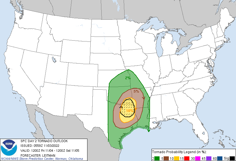
This tornado risk is centered over northeastern Texas, with a much lower risk extending north into our region. We will be monitoring this closely.
For today, it will be another windy and warm day with highs near 80 degrees.
Here is today's weather forecast timeline:
- Today: Mostly sunny with increasing afternoon clouds. South winds 15-30 mph. High: 79°
- Tonight: Becoming cloudy with a 60% chance of rain by sunrise. Low: 65°
- Friday: Cloudy with a 100% chance of rain. The rain may become heavy at times with a possibility of thunderstorms. The risk of severe thunderstorms is low. The wind will shift to the north by the end of the day. High: 68°
- Saturday: Cloudy with a chance of rain ending by 9 a.m. Some snow is possible, but more likely near the Iowa border. Low: 37° High: 55°
- Sunday: Mostly sunny and great weather for tailgating and the Chiefs game. High: 70°
Thank you for spending a few minutes of your day reading the weather blog and sharing in this weather experience.
Have a great day!
Gary
