


Good morning bloggers,
It is rather calm and nice on this Tuesday morning. The weather pattern is setting up for a possibility of severe thunderstorms tonight. There are two Royals games today in a day/night doubleheader and there may be a few weather challenges. I still expect both games to get played.
- A few showers and thunderstorms were developing over central Kansas this morning. An upper level disturbance is moving our way and will pass over the Kansas/Missouri border by early this afternoon. There is a chance this area of thunderstorms forming now will track through our area by noon.
- The second round of showers and thunderstorms is due tonight. This second round may be severe on it's leading edge.
Humidity is about to surge in from the south. There is a "moisture tongue", yes this is a real meteorological term we occasionally use, developing this morning. By 3 p.m., a surge of higher dew points will be moving in and you will notice the humidity increase by later today. This will be the fuel for tonight's thunderstorms.
Moisture Tongue

We will be monitoring areas over Nebraska, Kansas, Missouri, and Iowa for any organization to thunderstorms after sunset. It is always a bit difficult to know exactly where the thunderstorms will organize, and right now the most likely scenario is shown here.

By 11 p.m. tonight, shown above, you can see the orange and red echoes with two areas of strong to severe thunderstorms near Omaha, Nebraska, and over north central Kansas. These two areas are then predicted to join forces and start attacking our area with a severe weather risk by 3 a.m.:
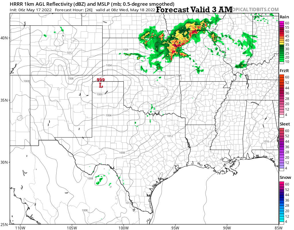
The main severe weather risk in this type of set-up will be damaging winds. There is a large hail risk as well, and this hail risk will come from any lead thunderstorms that form ahead of the line.
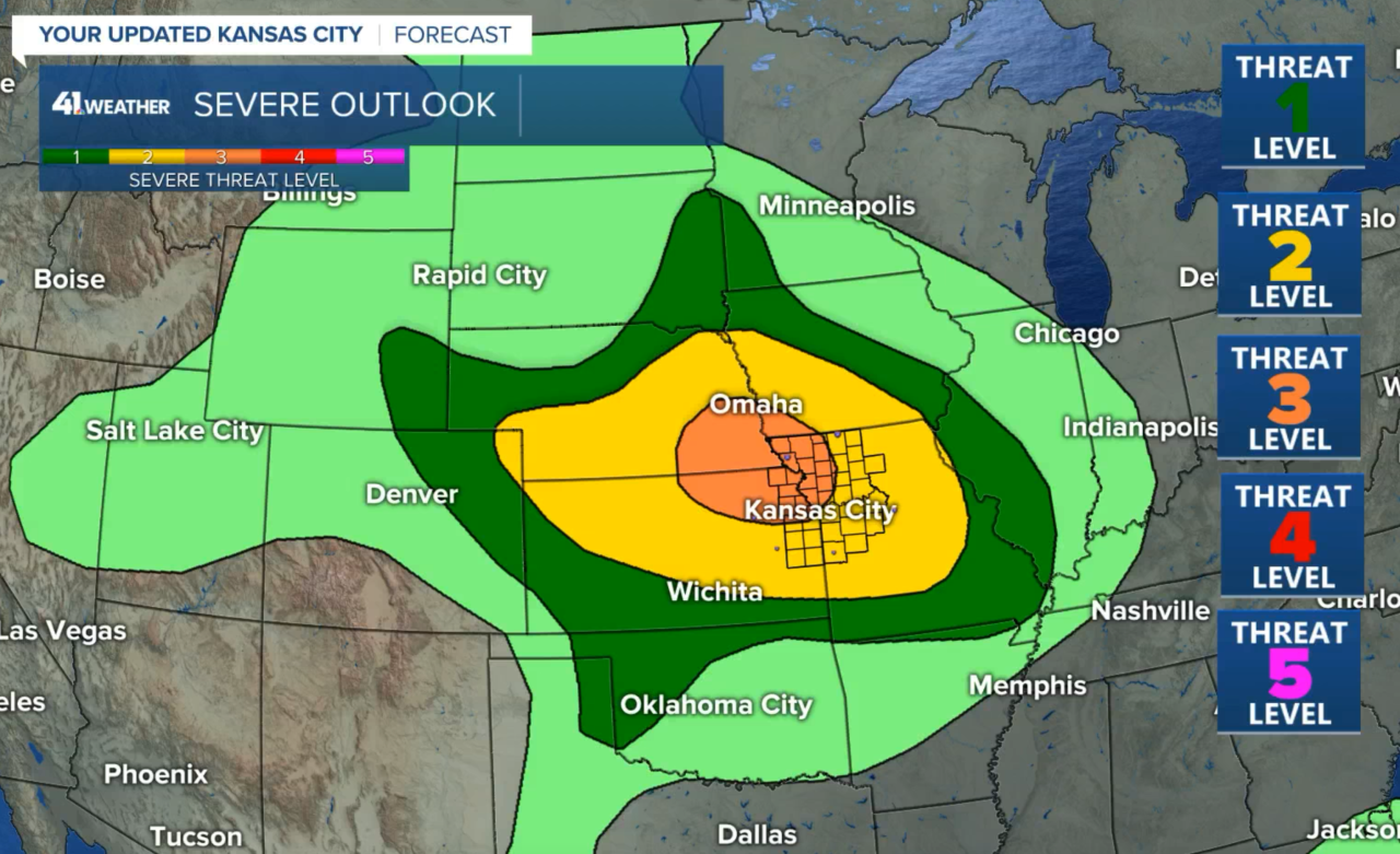
The severe weather risk has been upgraded to a level 3 out of 5 risk tonight.
From the SPC (Storm Prediction Center):
"This environment should be favorable for supercells with large hail. Hailstones of greater than 2 inches in diameter may occur with the strongest of updrafts. As the low-level jet increases during the late afternoon and early evening, forecast soundings along the track of the developing MCS, increase 0-3 storm relative helicities into the 300 to 350 m2/s2 range. This should be favorable for tornadoes, mainly with supercells. However, uncertainty does exist concerning the favored storm mode. The MCS could quickly take a linear form. This would make the wind damage threat greater than the tornado threat. This could be especially true as the MCS matures when discrete storms may become less likely. By mid to late evening, the MCS should become well-developed, moving southeastward into the area near Kansas City. Wind damage, large hail and a tornado threat appears likely. The severe threat could continue into the overnight period across the Ozarks and into southeast Kansas."
An MCS is a "Mesoscale Convective System", or organized area of thunderstorms. When these systems mature, there is an area of very heavy rain in the cooler air with severe weather on the leading edge of the organized system. We will be monitoring for this possible development tonight.
Possible Scenarios:
- Scenario #1 is the one I plotted in this blog. There will be a chance of showers and thunderstorms later this morning into early this afternoon from a lead wave. The main band with a severe weather risk is more likely around midnight to 5 a.m. 1 to 2 inches of rain are possible.
- Scenario #2 includes this all happening around three to four hours earlier. The severe weather risk may organize earlier and approach KC around 10 p.m. to midnight.
There are other possible scenarios, including some that have these thunderstorms miss KC but still hit areas northeast of KC. Right now, I am favoring scenario #1, or a cross between the top two scenarios. We will learn a lot more in the next few hours. The main risk again is damaging winds. There is a low end tornado risk and we will be monitoring for any small spin-ups on the leading edge of these thunderstorms tonight.
Thank you for spending a few minutes of your day sharing in this weather blog experience. We will be monitoring any thunderstorm development closely, so stay with KSHB-41 and we'll keep you advised.
Have a great day!
Gary
