


Good morning bloggers,
It is celebration Monday as the KC Chiefs beat the Cleveland Browns at Arrowhead Stadium Sunday, on a warm and humid afternoon. While the Chiefs were beating the Browns, a tropical storm was forming over the western Gulf of Mexico. This latest Tropical Storm, Nicholas, is the sixth named storm predicted this season by using the LRC. Before Nicholas, we had Claudette, Elsa, Fred, Major Hurricane Disaster Ida, & Mindy, all predicted at least 3 months before there was even a cloud. How is this possible? Well, for those of you reading this blog regularly, or following my Twitter or LinkedIn feeds, you know that this is a fact. Take a look at this storm this morning:

The center of Tropical Storm Nicholas is close to the south Texas coast, and if it stays out over water Nicholas may become a hurricane this before landfall. It is a bit west of the track we predicted this one would take. The LRC sets up each year in the fall, right around the end of the first week of October each year. So, a brand new pattern, one that has never happened before, will set up in around four weeks. Right now, we are experiencing the "same pattern" that set up last fall, and it continues to cycle regularly. We stumbled across the fact that tropical systems are predictable using the LRC around 10 years ago, and now we have gotten quite good at making these predictions.
Hurricane Zeta blasted into Louisiana in late October, and it was right then that we made the accurate prediction that there was a 64% chance (based on a 20-year analysis of previous hurricane seasons) of a named storm this hurricane season. When Claudette formed, it triggered an 84% chance of this storm forming right now. Here is the prediction made in February, or 7-months ago:
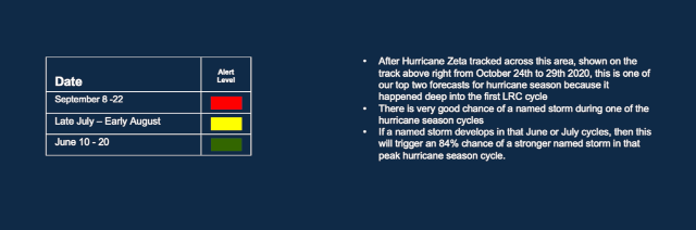
Tropical Storm Claudette formed June 19th and tracked into Louisiana. When Claudette formed we made a prediction of an 84% chance of a stronger named storm, as you can see above. And, Nicholas is a stronger named storm. This information box above is from our February prediction. The green alert level is the prediction of Claudette, and then the red alert level shows the 84% chance of a stronger named system verifying!
Thank goodness it is forming a bit west of our predicted track. Most of our predictions are much closer to the predicted track, but the dates predicted are spot on. If this system were just slightly farther east, it would likely have become a major disaster targeting Louisiana again, so Nicholas being close to the coast is a good thing today.

As you can see above, the three tracks are related. This is already the second time this has happened this season, and it has happened many other times, it actually happens just about every hurricane season. Hurricane Zeta, Tropical Storm Claudette, and Tropical Storm Nicholas are all related and the LRC allows us to make these accurate predictions. Here is the tweet from February:
This is the 7-month prediction of a named tropical storm, and a 3-month prediction of an 84% chance of a stronger named storm developing right now.
Kansas City Weather:
Okay, so we can predict tropical storms. Does that make it easier to predict whether or not it will rain in Kansas City Tuesday night? Well, the LRC does help, but it is still quite challenging. While Nicholas makes a likely Texas landfall later today, we will be monitoring a weak late summer cold front approaching Kansas City:

A slow moving front will be approaching Kansas City tomorrow evening. The front will likely be just north of KC by 7 PM Tuesday. There is a lot of energy in the form of temperatures in the 80s and dew points near 70 degrees on Tuesday ahead of the front. Thunderstorms will likely form, and the GFS model shows this forecast by 11 PM tomorrow evening:

This front will be subtly influenced by intensifying Nicholas. The front is forecast to stall and wash out Wednesday. As you can see below, by 7 AM Wednesday the front is stalling and the winds will likely return to the south by Wednesday night and Thursday. There is a very good chance of thunderstorms in Kansas City before this happens, and the timing is around sunset or shortly thereafter tomorrow night.

Have a great start to the week. How about those Kansas City Chiefs, coming from behind and beating the Browns. It was incredible seeing the full stadium and how loud we were as Chiefs fans yesterday. The home field advantage definitely came through. The next game at home is in two weeks. We made a prediction for September a month ago, and we will look at how accurate that forecast has been so far in a blog later this week.
Thank you for spending a few minutes of your day reading the KSHB-41 Weather Blog. We will be tracking the potential for thunderstorms in KC and strengthening Nicholas today and tonight. Have a great start to the week.
Gary
