


Update: Thunderstorms may form just after sunset
There is a small window for thunderstorms that will open up around 7 PM. Right after sunset a few thunderstorms will likely form. The first thunderstorms that form will be capable of producing hail large enough to be severe, perhaps the size of quarters. Then the thunderstorms will line up and zip southeast and out of here before midnight. We will be monitoring these closely.
Here is the previous blog:
Good morning bloggers,
There is a risk of severe thunderstorms tonight. And, there is a very good chance of a lot of rain in the next seven days. I hope everyone is doing well, and we will discuss these things and more in today's Gabbing With Gary blog.
Tonight's severe weather risk is limited for a couple of reasons. The cloud cover will limit heating and this means that we will have to wait until after sunset for even that first chance of a thunderstorm. The longer it waits, the more likely it is that thunderstorms will form south and east of our area. The window for the chance of thunderstorm development opens up around 8 or 9 PM. There is a capping layer, a warm layer aloft, around 8,000 to 10,000 feet above us that will prevent thunderstorms from forming earlier. If it were 85 degrees today, then thunderstorms would likely form earlier, but it won't be that warm anywhere, and thus we are going to have to wait and see where they from tonight. Let's take a look at the 6 PM and 9 PM surface forecasts from one of our models:

This 6 PM surface forecast shows the pattern at just before sunset. There is a cold front heading our way. Take a look at where it is at 9 PM tonight:

The front is moving, but it is about to stall later tonight and Thursday. Once the wind shifts to the north, the chance of thunderstorms will go way down. The chance is only around 30% anyway. On this forecast map, notice the little thin line forming northeast of KC. If this is right, then the KC metro area may see some lightning as the thunderstorms begin forming, but the chance of more than 15 minutes of rain is low. The first thunderstorms that form are capable of producing hail. Severe hail is when it reaches the size of a quarter or larger. A few thunderstorms are capable of being that strong, but again, the chance is fairly low at any given location.
Here are today's risks:

The yellow area shows the slight risk, and what we are calling a level 2 out of 5 risk:

Tonight's risk is a level 2 risk, and you can see the description of what is possible with this risk. The main risk type for today is hail. The chance of any other severe weather type is very low.
Windy Today:

When I was writing this blog, the winds were gusting to almost 40 mph in many spots. The wind gusts may reach 50 mph today and a Wind Advisory is in effect.
The Developing Weather Pattern:
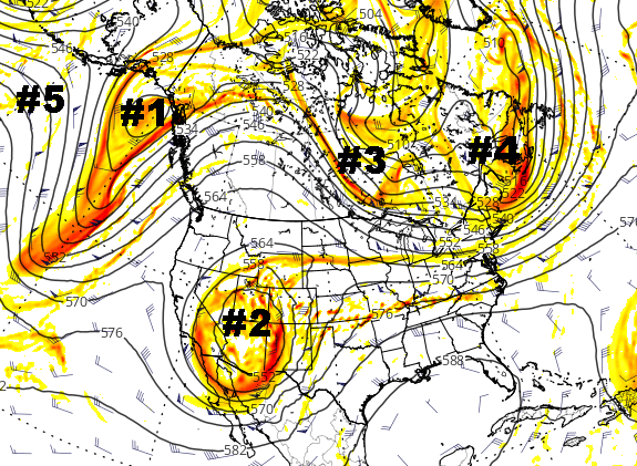
I numbered various features that we are analyzing. We will discuss the LRC in tomorrow's blog. Features #2 and #1 are the most important to track right now. These are the two strong storm systems that will produce very heavy rain and very heavy snow in the region.
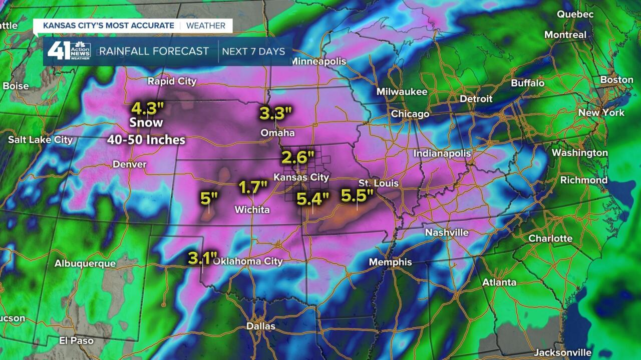
The outlook for the next seven days is for both of these storms to bring Kansas City good chances for thunderstorms, rain, and possibly even a few snowflakes as these systems move by. Snowfall amounts of up to four feet or more could bury many spots of Colorado and Wyoming. For KC, we are expecting 2" to 3" of rain in the next 7 days. We will go deeper into this developing weather pattern on 41 Action News.
Kansas City Weather Time-Line:
- Today: Mostly cloudy & windy. There is no chance of thunderstorms until after 8 PM. High: 74°
- Tonight: There is a chance of thunderstorms between 8 PM and 1 AM. Some hail is possible in the thunderstorms. Low: 41°
- Thursday: Partly cloudy. Cooler. High: 59°
Thank you for spending a few minutes of your day reading today's blog entry. If thunderstorms do develop tonight, we will try to update the blog, and of course we will be monitoring it on 41 Action News. Stay with 41 Action News, and we'll keep you advised. Hold onto your hats today. It will be windy. Have a great Wednesday.
Gary
