


KANSAS CITY, Mo. — Good morning bloggers,
Here we go again! Another storm is targeting our area and I know one thing for certain. This storm goes through a major transition as it is passing Kansas City on its journey to be an even stronger storm in the eastern U.S. Let's take a look at the complexity. But, I would like to begin with a look at January in Kansas City.
January in Kansas City (From Hugh Crowther, who sent me these stats yesterday):
- January is the coldest and driest month of the year for Kansas City. The average daily high is 37.1 degrees, the average daily low is 18.8 degrees and the mean temperature for the month averages 28 degrees.
- The average precipitation is just 1.26 inches, which includes 5.2 inches of snow.
- On average, there are two days in January with a high temperature of 60 degrees or above, and three days with a daily high colder than 20 degrees.
- On average, there is one day with a low of 40 degrees or above, and two days with a low of zero degrees or colder.
- On average, there are seven days with measurable precipitation, including three days with 0.10 inches or more, two days with 0.25 inches or more and one day with 0.50 inches or more.
- On the average there are four days with measurable snowfall, including three days with half an inch or more of snow, and two days with an inch or more of snow.
- The sunrise is the latest in the year (7:37 a.m.) for the first 12 days of the month, but is at 7:25 a.m. by the end of the month. The sunset is 5:06 p.m. at the start of the month but is 5:38 p.m. by the end of the month. The amount of daylight thus increases during the month from nine hours and 29 minutes to 10 hours and 13 minutes.
- Even though daylight is increasing during the month, January is 4 degrees colder than December because of a lag of about one month between the shortest days and the coldest temperatures.
Where is this approaching storm now?
The storm we are trying to predict barely exists at this moment. The top left picture, below, shows the energy that will begin carving out a very snowy U.S. storm system. It is just a flat flow of vorticity. The top right picture shows this beginning to develop, and then it begins a dive south. It is caught in a positively tilted trough, which adds to the complexity of our forecast. And, on the bottom right picture you can see a circle, or upper-level low that forms just west of Kansas City Saturday morning:

The fact that this storm doesn't really even exist yet, and it is just a stream of energy aloft, should open your eyes to how complex this really is. Now, I still have confidence that this system will develop. After the storm passes by Kansas City it will intensify and produce a foot or more of snow in southern cities that have been getting hit in Tennessee and Kentucky. Look at the snow forecast from the American Model.
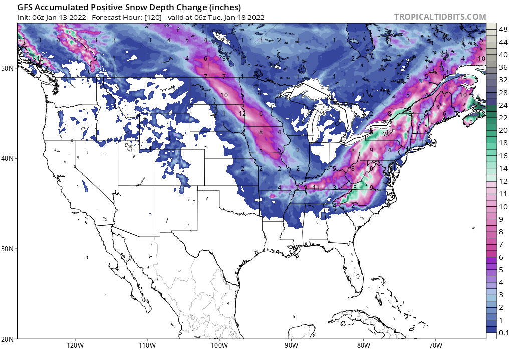
This model and others are similar, showing a wide area of 4 inches to 18 inches of snow from North Dakota southeast into northern Missouri. It then breaks briefly and then starts generating again. That brief break just happens to be when it is passing over our region.
850 mb forecast valid 6 a.m. Saturday (NAM Model):

Many of the models are showing this low height area at 850 mb, or around 5,000 feet above us, on Saturday morning. This is valid at 6 a.m. Saturday. This shows warmer air being forced into the colder air around this system. It will take around six hours to pass us, which will provide a window for snow Friday night into Saturday morning.
NAM Model (6 a.m. Saturday)

ICON Model (6 a.m. Saturday)

GFS (American Model (6 a.m. Saturday)

Look closely at the three predictions for Saturday morning. They all have Kansas City in this snowstorm Saturday. If it lasts less than four hours, then a dusting to an inch is more likely. If we are more in the middle of it, which would be caused by a stronger system digging south over Kansas, and it lasts six hours or longer, then higher totals are possible.
We also have temperature concerns. There is an "inverted" trough north of the surface low in Arkansas, near the Texas border. This may hold temperatures near or just above 32 degrees. If it is 33 or 34 degrees, or even a bit warmer Friday night into early Saturday, then the dusting is even suspect.
For these reasons, we are still being conservative on our snowfall forecast near Kansas City. We are currently forecasting a dusting to 3 inches, with higher amounts around 75 miles north and northeast of Kansas City.
New data update:
Every model is in but one, the European Model will be in soon. One of the models literally had a dusting in a few spots and up to 3" in others, with those higher amounts 75 miles north and northeast. Most of the other models had 1" low to 6" high. We will be sticking to our dusting to 3" forecast until we get any more evidence that it is potentially more or less.
Enjoy today: It is a great winter day. Expect a high of 55°.
Thank you for spending a few minutes reading the weather blog and sharing this weather experience. Have a great day. We will go in-depth and look at the trend on this storm today and tonight on KSHB 41 News. We will have a new blog posted by 8 AM tomorrow.
Gary
