


KANSAS CITY, Mo. — After rains and storms soaked the Kansas City area Friday morning, additional thunderstorms are possible Friday afternoon and evening.
LINK | KSHB 41 Weather Radar
LINK | KSHB 41 Traffic
LINK | KSHB 41 Weather forecast
LINK | KSHB 41 Weather Blog
LINK | KSHB 41 Severe Alerts
Check back throughout the day for updates.
UPDATE, 12:20 a.m. | More than 3,700 customers in the Board of Public Utilities service territory lost power late Friday night as storms moved through the area.

UPDATE, 11:55 p.m. | The tornado warning for the Kansas City area will be allowed to expire. Severe storms remain possible early Saturday.
11:52pm-Tornado warning is being lifted and no longer poses a threat https://t.co/T4LCgnosDh
— Wes Peery (@WesWeather) March 7, 2026
UPDATE, 11:45 p.m. | A tornado warning has been issued. Live coverage:
UPDATE, 8:20 p.m. | A tornado watch has been issued for the immediate Kansas City area until 4 a.m. Saturday.
UPDATE, 7:40 p.m. | The National Weather Service has expanded a tornado watch to include Linn County in Kansas, and Cass, Johnson, Pettis, Lafayette and Saline counties in Missouri.
UPDATE, 6 p.m. | Bates and Henry counties in Missouri have been added to a tornado watch until 1 a.m. Saturday.
Bates County and Henry County in Missouri have been added to a Tornado Watch until 1 AM. pic.twitter.com/tnd90ZrqQb
— Caleb Chevalier (@MetCalebC) March 6, 2026
UPDATE, 4 p.m. | Here's the latest forecast update from KSHB 41 Weather's Caleb Chevalier:
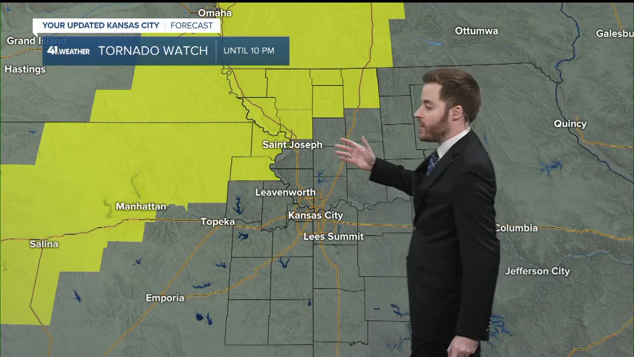
UPDATE, 3:20 p.m. | The National Weather Service has issued a tornado watch for portions of the KSHB 41 viewing area through 10 p.m.
The watch stretches from southwest of Salina, Kansas, and runs to the northeast, including the towns of Manhattan, Kansas, St. Joseph, Missouri, and up to Des Moines, Iowa.
A tornado watch has been issued for parts of Iowa, Kansas, Missouri and Nebraska until 10 PM CST pic.twitter.com/955XHG4OEU
— NWS Topeka (@NWSTopeka) March 6, 2026
UPDATE, 3 p.m. | A bridge carrying parts of W. 287th Street in Miami County was washed out from Friday's rains.
The Miami County Sheriff's Office has blocked off the road between Oxford Road and US 69 Highway. The road could remain closed for an extended period.
UPDATE, 2:30 p.m. | Olathe Fire Department crews located a fire in the basement of a house on West 146th Terrace during a "lightning strike investigation" around 12:25 p.m. Friday.
Lightning appeared to have hit the roof of the structure.
While no injuries were reported, four people were temporarily displaced. The Olathe home sustained "significant" damage inside, per a social media post from OFD.
The Olathe Police Department, Overland Park Fire Department and Johnson County MED-ACT assisted at the scene.
UPDATE, 12:35 p.m. | Missouri Governor Mike Kehoe signed Executive Order 26-08 activating the State Emergency Operations Plan for threat or severe weather. Under the Order the Emergency Operations Plan enables state agencies to coordinate directly with local jurisdictions to expedite assistance. Governor Kehoe says "I urge all Missourians to pay attention to their local weather forecasts, follow official warnings, and have multiple ways to receive alerts - especially overnight."
You can view the order here.
UPDATE, 11:50 a.m. | KSHB 41 Weather's Jeff Penner is tracking a new round of storms set to affect the Kansas City area between noon and 2 p.m. Friday. These storms are not anticipated to be severe, but could bring heavy rainfall in spots.
A new round of heavy rain and thunderstorms are approaching from the southwest. This round will affect most of KC between noon and 2 PM. Some flash flooding is possible. Go slow to avoid hydroplaning. @KSHB41 pic.twitter.com/R5AxMwtsrz
— Jeff Penner (@JeffPennerKSHB) March 6, 2026
UPDATE, 11 a.m. | We caught up with KSHB 41 Weather's Jeff Penner for a quick Facebook live update on today's forecast:
UPDATE, 10:40 a.m. | The National Weather Service in Kansas City/Pleasant Hill, Missouri, is reminding residents about lightning safety as storms hit the area.
Each year in the United States, thunderstorms produce 20-25 million lightning flashes that strike the ground, killing an average of 20+ people and injuring hundreds more - often in devastating and permanent ways. https://t.co/lBsi6FjXq5 pic.twitter.com/18tmzaNfZs
— NWS Kansas City (@NWSKansasCity) March 6, 2026
Some tips to remember include going indoors when thunder roars or when lightning flashes.
UPDATE, 10:35 a.m. | Continued rains Friday morning are causing some localized flooding in Grandview.
UPDATE, 10:30 a.m. | Students in Pleasant Hill will get an early start to the weekend.
Power outages associated with this morning’s storms forced Pleasant Hill R-3 to close schools early.
The district said high school and middle school students were dismissed at 9:30 a.m. Friday. Elementary school students are set for dismissal at 10:30 a.m.
Pleasant Hill R-III is closing (HS & MS 9:55 am and IS, ES, and PS at 10:30 am) today, 3/6/26. We are without power and unable to provide lunch to our students. Buses will run regular routes. Parents can pick up their children now.
— Pleasant Hill R-III (@PHR3SD) March 6, 2026
The district says buses will run regular routes. Parents are able to pick up their children as of 10 a.m.
UPDATE, 10 a.m. | The Big 12 announced Friday morning it has moved some of its Big 12 Women's Basketball Championship Fan Fest events inside the T-Mobile Center due to Friday's continued rain.
LINK | Big 12 moves Friday Fan Fest, pep rallies inside, due to weather, threat of storms
UPDATE, 9:30 a.m. | An Evergy spokesperson said Friday morning's storms have caused isolated power outages across their service territory. More than 2,000 customers were without power at one point in Johnson County, Kansas. Crews have since worked to restore power in those areas.
EARLIER | Rain and thunderstorms overnight and early Friday morning are having an impact on the morning commute.
Overnight storms slowed some early morning traffic.
Several accidents were reported across the metro, none with serious injuries so far.
Reporter Grant Stephens continues to travel the metro in Storm Tracker checking out road conditions on the highways.
KSHB 41 meteorologist Jeff Penner continues to monitor conditions and has the latest info. in his forecast.
