


KANSAS CITY, Mo. — Good Friday bloggers,
We are tracking three main periods of thunderstorm activity and the threat of severe weather. Let's go through this.
PERIOD 1 (NOW-NOON):
We are seeing several clusters of rain and non-severe thunderstorms. Very heavy rain is the main threat. So go slow to prevent hydroplaning. This is when water gets under the tire and it is like driving on ice and you can slide around. Temperatures will be 60°-65°.
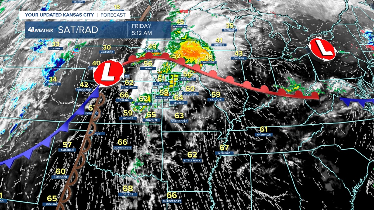
This was the radar at 5:10 a.m:

The last round of thunderstorms will end around noon.

Rainfall as of 6 a.m. varies greatly. Now, these are radar-estimated rainfall totals, so your rain gauge may read differently. The heaviest, around 1", was found in Johnson County, Kansas. But, as I was writing this, Jackson into Clay counties were catching up fast.
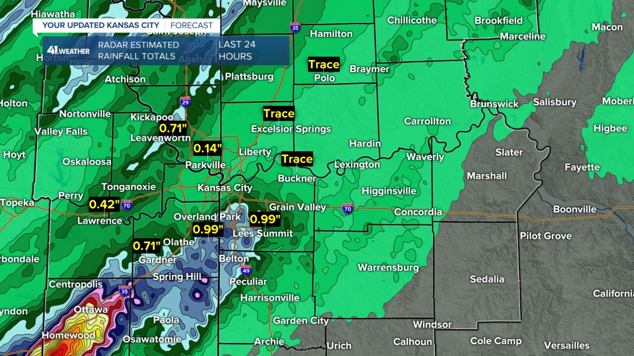
There was some flash flooding around Interstate 35 southwest of Ottawa, where 2"-4" of rain occurred between 1 and 3 a.m.

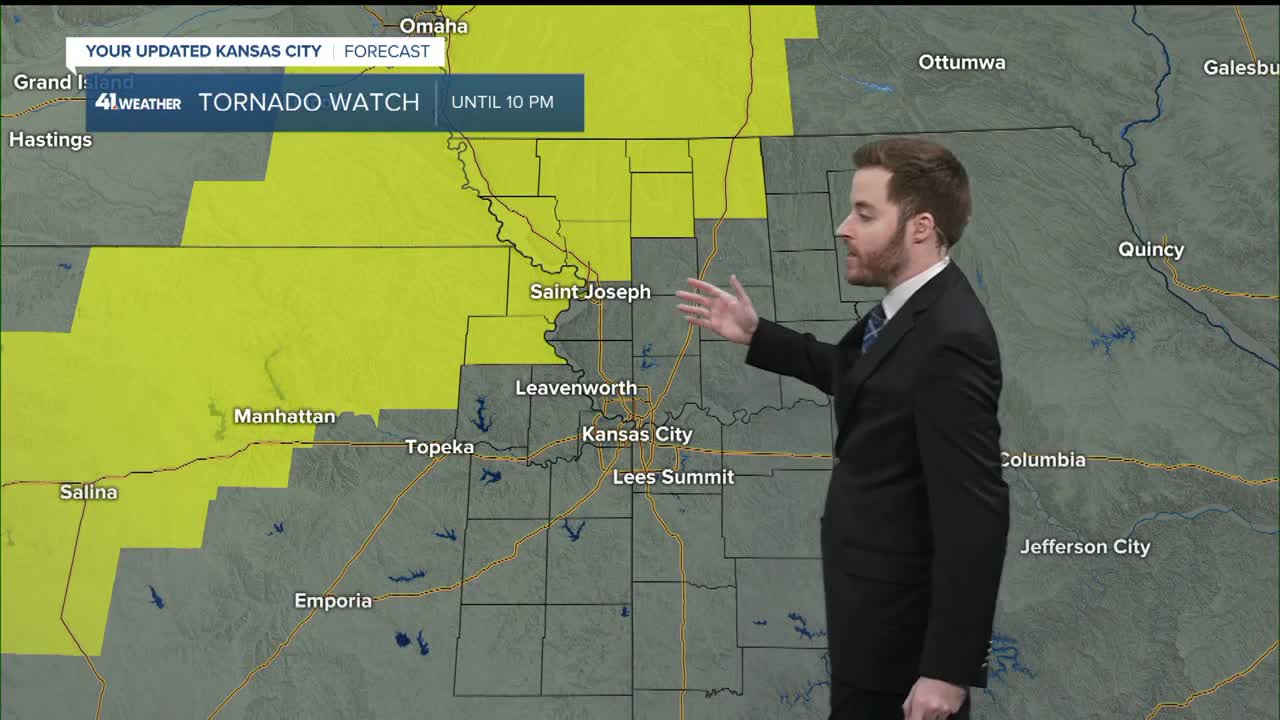
Here is the setup. We have a surface low in southwest Nebraska as of 6 a.m. with a cold front, warm front and dry line emanating from the low. This is called a "triple point," and when a meteorologist sees this, severe weather is the first thought that comes to mind.
The setup this afternoon will feature the surface low taking off to southeast South Dakota with the cold front moving into central Kansas. The dry line will shift south along the cold front. So, the organized "triple point" is not there. That being said, the cold front and dryline and warm front can all generate severe thunderstorms. Now, look at the temperatures. There is a slot of highs 65°-70° due to clouds and the fact that the current rain and thunderstorms don't end until noon.
If this remains the case, the thunderstorms that form on the front with a few ahead of the front will have less chance to be severe. This is because heat/moisture is the fuel for thunderstorms. The more heat/humidity, the bigger the cumulonimbus cloud can grow, which could lead to severe weather.
Well, we have the moisture, but if temperatures stay between 65° and 70°, the thunderstorms will be heavy with gusty winds and some hail, but the severe threat will greatly diminish. We lean in this direction.

But, there is always a but. We are still in a level 3 of 5 risk for severe weather. Because, if it does warm up to 73°-78°, we could have a severe weather problem this afternoon and night. The chance is low, but not zero.

PERIOD 2 (3-8 PM):
We will be tracking areas of scattered showers and thunderstorms. If there are a lot of clouds as is shown, then this period will not have much severe weather. If it warms up to the 70s then we will have to watch these thunderstorms.

By 7-8 p.m., you can see a line of thunderstorms crossing the state line. Again, we will watch these closely. Also a line of thunderstorms will be forming along the cold front.

PERIOD 3 (8 PM-2 AM TONIGHT):
The line of thunderstorms with the cold front is likely and will cross the viewing area between 8 p.m. and 2 a.m. from west to east. It will cross Kansas City around midnight.
This line will have the potential to produce damaging wind, hail and a brief small tornado. There are two factors that could limit the severe threat. One, overall, it may be too cool, especially if it was too cool for the afternoon severe threat. Two, if you look closely, the line is just behind the cold front. If this happens, the line will be in the colder air behind the front and this will greatly lower the threat. A brief period of heavy rain is likely.

The bottom line is that we have to watch periods two and three closely and take them one at a time.
RAINFALL FORECAST:
Some locations will see a new .25" or less rain while others will see 1"-2". It depends where the thunderstorms set up.

The heaviest, most widespread rain will occur from Iowa to Wisconsin and southern Arkansas/northern Louisiana to the southeast USA.

SEVERE WEATHER THREAT SUMMARY:

Stay weather aware
Stay with KSHB 41 and we'll keep you advised
Stay healthy and have a great weekend.
