


KANSAS CITY, Mo. — Some winter forecast signs are pointing in the snowy direction. At the same time, we are still waiting for our first true cold blast of the season!
Will the winter be cold and snowy, warm and dry, or somewhere in between?
We already know that Kansas City is one the most difficult places in the world to predict the weather. The biggest reason is because of where we live.
Kansas City is not too far from a huge north/south mountain chain known as the Rocky Mountains. And, we are also due north of a huge body of warm water known as the Gulf of Mexico. Air will come over the Rocky Mountains and as it moves out over the plains states, it will then bump into the warm and moist air from the Gulf of Mexico.
When these two air masses collide, violent weather often results. There are more tornadoes east of the Rocky Mountains between Colorado and the east coast, than anywhere else in the world. Nearly two-thirds of all of the world's tornadoes happen in this region.
One prediction we are making this early, using hints from what already started happening in October, is for 100 or more tornadoes to happen in the state of Kansas in 2022 (Kansas averages close to 90 tornadoes/year). But, what do these early signs mean for this winter? The pattern we will have next spring is directly related to the pattern we have developing now.
We use a weather forecasting technique that taps into the knowledge of the cycling patterns of the Northern Hemisphere.
The KSHB bloggers named this cycling pattern the Lezak Recurring Cycle, or the LRC, around 20 years ago after they had noticed how incredibly accurate the predictions were becoming.
Look at how well we did last year with the winter forecast.

Using the LRC and an understanding of the developing weather pattern, I made the prediction for the winter snowfall total to be 15.5 inches last winter, and what happened? Exactly 15.5 inches of snow fell.
Predicting the amount of snow for an entire season is no easy task. Predicting snow for an approaching storm is even difficult. We will often predict a range of 1 to 4 inches in a small storm, and 3 to 8 inches of snow in a stronger storm system.
The amount of snow that falls from these storm systems will almost always fall within those predicted ranges. So, predicting an exact amount for a storm is quite difficult, not to mention an entire season's total.

There are a lot of pieces in the complex atmospheric puzzle that we have in our weather forecasting toolbox.
The LRC is the centerpiece of this huge and complex atmospheric puzzle. It has three main aspects:
- A unique pattern sets up each fall; a pattern that has never happened before.
- Anchor troughs and ridges become established in the river of air cycling through above us, around 15,000 to 30,000 feet up. The anchor troughs are where storm systems are more likely to be stronger and more frequent, and the anchor ridges are where storm systems will be weaker and less frequent. If you are near an anchor ridge, your region is more likely to be dry and a bit warmer.
- Most importantly, the pattern is cycling, and a new cycle length develops, becomes established, and cycles over and over again until the next fall.
The new LRC was still evolving as we made this initial winter forecast. We will learn a lot more in the coming weeks, but for now, let's make some conclusions.
This pattern has started out quite mild. Kansas City has not dropped below 20 degrees yet, and we are still waiting for our first measurable snow.
We are not alone. Denver, Colorado, has already set their record for the latest first measurable snow, and they are still waiting for that first 0.1 inches. Storm systems in October were strong, and yet they produced more rain than snow, even in North Dakota. What is going on?
There are other pieces to the big atmospheric puzzle that are influencing this pattern.
La Niña:
La Niña, which is the colder phase of The El Niño Southern Oscillation Index, or ENSO, is the cooling of the Tropical Pacific waters.
This winter is going to have an influence from La Niña, and for KC, this more often is seen in the precipitation patterns. The heavier precipitation is more likely to form east of Kansas City during La Niña years, but again, this is just an influence on the overall weather pattern.
Arctic Oscillation (AO) & North Atlantic Oscillation (NAO):
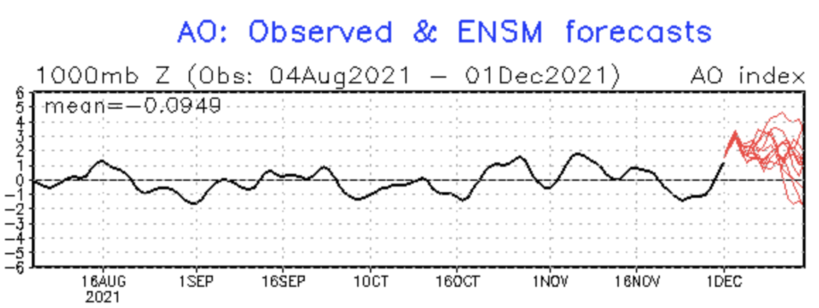
The AO, shown above, has just in the past few days surged positive.
- When the AO & NAO are positive, Arctic Air is more likely to be held up north over northern Canada, leaving the United States warm. The jet stream energy is spread out and storm systems are usually weaker.
- When the AO & NAO are negative, Arctic air is more likely to blast south into the United States, and this often results in strong storm systems.
The AO going into the positive territory in early December is having some impact on the weather pattern. This index and other factors are not good signs of a snowy winter ahead. We expect this to shift and dip negative as early as late December. If it does not, then a warm winter is entirely possible.
The LRC is still the more dominant and larger piece of the puzzle. Once we learn a bit more, we will be able to predict when storm systems are most likely going to strike.
Last year, for example, Weather 20/20, LLC used the LRC to predict eight of the nine land-falling named tropical storms (Weather2020.com). When will winter storms strike KC? When will there be severe weather risks? We will know enough soon to make these longer-range predictions.
For now, we know just enough to make our winter forecast. Here is what we are seeing:

Even though it has started out warm and dry, we are forecasting a flip in the pattern in a few weeks.
This flip in the pattern will lead to a few cold blasts, and possibly one brutally cold stretch lasting 10 days to two weeks.
The stormy part of the pattern is due to cycle through between mid-December and mid-January, and then again in mid-February into early March before spring arrives.
There are still some big questions that we are still analyzing for the answers. These next few weeks will go a long way in providing a few more clues for what we will experience this winter. The seeds have been planted, and they are being fertilized right now. This warm start to the season certainly has our attention.
Here are our weather team's snowfall predictions:
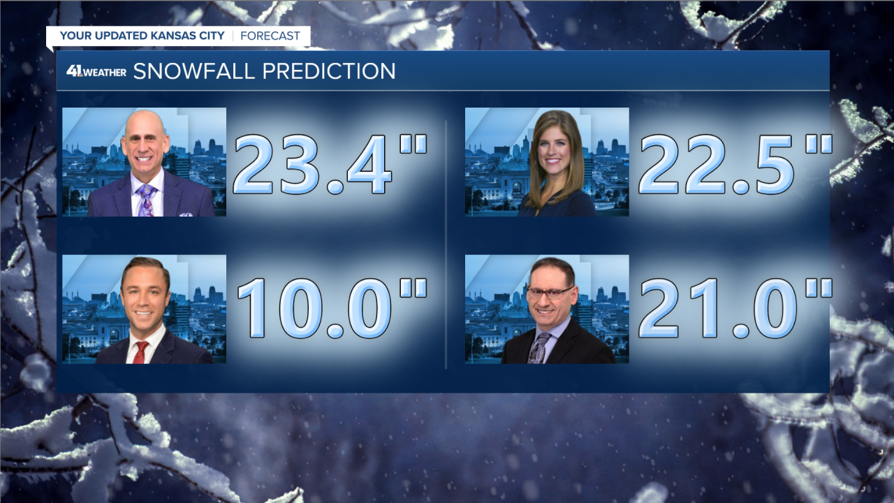
- Our weather team is predicting between 10 inches and 23.4 inches of snow this winter.
- This averages out to 19.2 inches of snow as a weather team prediction.
- The average annual snowfall is 18.6 inches.
One statistic to track: In the past 20 years, when 3.7 inches of snow or more falls in December, then the average snowfall for the winter is close to 25 inches (average for seven of the past 20 years). When less than 3.7 inches of snow falls in December, then that average snowfall for the season has been close to 13 inches less (average for 13 of the past 20 years).
We will know this answer, to how much snow falls in December, in just the next four weeks.
I know most of the kids are rooting for snow. We will be monitoring these trends closely.
For now, it is starting out as a very mild winter. We are forecasting a flip to cold in the next few weeks, as you will see in the winter forecast video. Stay with KSHB 41 Weather and we'll keep you advised!
-Gary Lezak
![020626_KSHB_Image_NXA_Web_Standard Cube[88].jpg](https://ewscripps.brightspotcdn.com/dims4/default/0ead409/2147483647/strip/true/crop/300x225+0+13/resize/960x720!/format/webp/quality/90/?url=http%3A%2F%2Fewscripps-brightspot.s3.amazonaws.com%2F8f%2F6c%2Ffad8bd2346c5a4d4ead793017d4a%2F020626-kshb-image-nxa-web-standard-cube88.jpg)