


KANSAS CITY, Mo. — The Kansas City region is included in a tornado watch that stretches from Oklahoma to Nebraska and Iowa through 9 p.m. Monday.
The Storm Prediction Center in Norman, Oklahoma, says wind gusts could exceed 75 mph and hail the size of apples.
LINK | Latest weather forecast
LINK | KSHB 41 Interactive Radar
LINK | Latest watches and warnings
KSHB 41 Weather's Wes Peery says storms could develop in eastern and southeastern Kansas through 3 p.m.
If a tornado warning or destructive thunderstorm warning threatens the Kansas City area, you can watch live coverage in the video player below.
—
UPDATE, 10:10 p.m. | Rainfall totals from Leavenworth County, Kansas, Emergency Management Office from today's storm: 2.10 inches in north Leavenworth, and 2.07 inches in south Leavenworth.
UPDATE, 9:50 p.m. | Power outage updates: Evergy (15, 278), Board of Public Utilities (157) and Independence Power and Light (697).
UPDATE, 9:30 p.m. | The Miami County Sheriff's Office shared the below message on its Facebook page.
"A fast-moving storm caused significant disruption across Miami County this afternoon. Fortunately, no injuries have been reported despite some serious incidents, including a tree falling onto a residence in Paola and a semi-truck rollover on K68 Highway diverting traffic.
Between 3:15 p.m. and 6:25 p.m., the Miami County Communications Center handled 91 non-emergency calls and 25 emergency (911) calls related to the storm.
Deputies responded to:
6 reports of debris in the roadway
5 downed power lines
1 leaning power pole
1 grass fire
2 non-injury accidents
1 motorist assist
"City police and fire departments were also actively responding to storm-related incidents within their jurisdictions and opened storm shelters as a precaution.
"We extend a sincere thank you to the Miami County, Kansas Road and Bridge Department, for their quick and effective response in clearing roadways. Crews will continue cleanup efforts over the next few days to address the remaining storm damage.
"Looking ahead: More storms are expected tonight, with continued showers into tomorrow. There is also a potential for minor flooding. We urge residents to stay weather-aware and take necessary precautions during inclement weather.
"Stay safe, Miami County!"
UPDATE, 8:50 P.M. | The National Weather Service extended the tornado watch covering the entire Kansas City area. It is now in effect until 11 p.m.
UPDATE, 8:42 p.m. | The National Weather Service has canceled the tornado warning for Platte County.
UPDATE, 8:35 p.m. | A severe thunderstorm warning remains in effect for northwestern Wyandotte, Leavenworth, west central Johnson and southern Atchison counties in Kansas.
UPDATE, 8:31 p.m. | A tornado warning has been issued for Platte and Buchanan counties in Missouri, per the National Weather Service.
UPDATE, 8:04 p.m. | "Evergy crews are restoring power as multiple waves of storms move through the area. This afternoon and early evening, storms began moving across our service area," the utility shared on its website. "The worst damage was in the Kansas City metro area, where we saw peak outages around 33,000 customers. Damage from the strong winds include downed wires and broken poles. Evergy crews began working on repairs and restoring power right away and will continue working through the night."
UPDATE, 6:40 p.m. | Just after 6:30 p.m., Evergy reported 34,033 customers without power, BPU showed 17 outages affecting 472 customers, and IPL reported 47 outages affecting 1,316 customers.
UPDATE, 6:31 p.m. | KSHB 41's Alyssa Jackson and Ryan Gamboa provided live looks at storm damage in Prairie Village and Belton in the 6 p.m. hour.
UPDATE, 7:44 p.m. | Evergy reports 25,860 customers without power as of 7:24 p.m.
UPDATE, 5:59 p.m. | The Johnson County, Kansas, Sheriff's Office posted a video on Facebook captured by an employee's dashboard camera while driving near Santa Fe and Interstate 35 on Monday afternoon.
Drivers are advised to be weather aware and to remember to turn around, don't drown.
UPDATE, 5:52 p.m. | KSHB 41's Ryan Gamboa went to the scene of a tree on a home at 165th and Holmes, north of Loch Lloyd.
No injuries were reported, but Gamboa said the tree fell through the house, causing a small hole, and damaged a car across the street.
Belton fire personnel are on the scene.


UPDATE, 5:44 p.m. | Belton's emergency management director shared two images of damage — one of a downed tree and another of a downed light pole.


UPDATE, 5:38 p.m. | KSHB 41's Wes Peery previews what the rest of the day could bring in an updated forecast.
UPDATE, 5:29 p.m. | Southern Daviess, eastern Clinton, northeastern Clay, northern Ray, southeastern DeKalb and Caldwell counties remain in a severe thunderstorm warning until 5:45 p.m.
Penny-sized hail and 70 mph winds are possible.
UPDATE, 5:20 p.m. | As of 5:15 p.m., Evergy reported 32,804 customers out, BPU said 23 outages were affecting 714, and IPL's outage map showed 33 outages affecting 938 customers.
UPDATE, 5:15 p.m. | A severe thunderstorm warning remains in effect until 5:30 p.m. for southeastern Clinton, southeastern Ray and southwestern Caldwell counties.
The warnings have expired for Missouri's Johnson, Cass, Jackson and Lafayette counties.
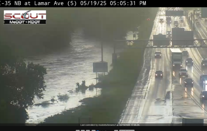
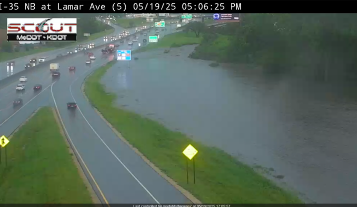
UPDATE, 5:11 p.m. | The Missouri Department of Transportation reports flooding from the creek close to Interstate 35 at Lamar Avenue.
UPDATE, 5:05 p.m. | A severe thunderstorm warning remains active until 5:15 p.m. for central Cass, southeastern Jackson and northwestern Johnson counties in Missouri.
UPDATE, 4:55 p.m. | Just before 5 p.m., more than 30,000 people were without power across the Kansas City area.
UPDATE, 4:52 p.m. | KSHB 41 viewers are beginning to submit images of storm damage, including one viewer in Prairie Village.

UPDATE, 4:36 p.m. | Power outages continue to grow in the Kansas City area.
As of 4:305 p.m., Evergy reported 21,528 customers without power, the Board of Public Utilities in Kansas City, Kansas, reported 15 outages affecting 322 customers, and Independence Power and Light reported eight outages affecting 282 customers.
UPDATE, 4:31 p.m. | A destructive thunderstorm is moving into the Kansas City area.
Wind gusts up to 80 mph and penny-sized hail are possible in east-central Wyandotte County, northeastern Miami County and eastern Johnson County in Kansas. The same warning goes for northwestern Cass and Jackson counties in Missouri.
75 MPH WIND GUST AT OLATHE/JOHNSON COUNTY AIRPORT. 75 TO 80 MPH WINDS MOVING THROUGH EASTERN JOHNSON COUNTY KANSAS INTO JACKSON COUNTY MISSOURI. This is a distructive Storm! #KCMO #KC Metro #kswx #mowx
— NWS Kansas City (@NWSKansasCity) May 19, 2025
UPDATE, 4:27 p.m. | Until 5:15 p.m., Wyandotte, Buchanan, Clinton, Clay, Ray, Platte and Jackson counties are included in a severe thunderstorm warning.
Wind gusts of up to 70 mph are possible.
The NWS said there could be "considerable tree damage" as well as damage to mobile homes, roofs and outbuildings.
Severe Thunderstorm Warning including Kansas City MO, Kansas City KS and Liberty MO until 5:15 PM CDT. This storm will contain wind gusts to 70 MPH! pic.twitter.com/8FByuzVCd9
— NWS Kansas City (@NWSKansasCity) May 19, 2025
UPDATE, 4:20 p.m. | A flash flood warning has been issued until 8:15 p.m. for central Leavenworth, Johnson (Kansas), Wyandotte, northwestern Cass, Clay, western Jackson and Platte counties.
Across the Kansas and Missouri counties, small creeks and streams, urban areas, highways, streets, underpasses, poor-draining areas and other low-lying areas are at risk of flash flooding, per the National Weather Service.
UPDATE, 4:16 p.m. | Vehicles driving on Interstate 35 at West Pennway are navigating standing water.

UPDATE, 4:14 p.m. | The following Missouri counties are included in a severe thunderstorm warning until 5 p.m.: Daviess, Grundy, Clinton, Clay, Ray, Carroll, Caldwell, Jackson and Livingston.
The National Weather Service said multiple reports of quarter to half dollar-sized hail have been reported from Kearney and Holt.
Severe Thunderstorm Warning including Liberty MO, Gladstone MO and Excelsior Springs MO until 5:00 PM CDT pic.twitter.com/S9cvTkfSz0
— NWS Kansas City (@NWSKansasCity) May 19, 2025
UPDATE, 4:08 p.m. | KSHB 41's Wes Peery advises drivers to be careful as street and stream flooding is occurring.
4:05pm MON--Absolutely pouring ontop of Kansas City with hail and gusty windy.
— Wes Peery (@WesWeather) May 19, 2025
Street and stream flooding is occuring so PLEASE drive carefully!#mowx #kswx #kcwx pic.twitter.com/sptebeEdf2
UPDATE, 4:06 p.m. | A viewer in Kearney, Missouri, shared an image of hail that fell in the area Monday afternoon.

UPDATE, 4:03 p.m. | Storm reports across the area are beginning to roll in. Trained storm spotters measured a 62 mph wind gust in Overland Park at 143rd and 69 Highway before 4 p.m. Additionally, Shawnee's emergency manager noted hail near 65th and Quivira, and an NWS Kansas City meteorologist said trees are reportedly down in Pleasanton.
UPDATE, 3:52 p.m. | A severe thunderstorm warning has been issued until 4:30 p.m. for northeastern Wyandotte County and northeastern Johnson County in Kansas.
The same warning applies to southeastern Clay, southeastern Platte and northwestern Jackson counties in Missouri.
Ping pong-sized hail and 60 mph wind gusts are possible.
Severe Thunderstorm Warning including Kansas City MO, Overland Park KS and Kansas City KS until 4:30 PM CDT pic.twitter.com/fN0GX7xnuG
— NWS Kansas City (@NWSKansasCity) May 19, 2025
UPDATE, 3:45 p.m. | Rain was coming down around 3:40 p.m. in Overland Park with dime-sized hail, per KSHB 41's Jeff Penner.
Torrential rain and dime size hail in south OP. @KSHB41 pic.twitter.com/OvANUMUPDd
— Jeff Penner (@JeffPennerKSHB) May 19, 2025
UPDATE, 3:38 p.m. | KSHB 41 Weather's Jeff Penner said to expect large hail and wind gusts up to 60 mph from the thunderstorms that will cross most of the metro between now and 5:30 p.m.
There is also the potential of flash flooding.
A cluster of thunderstorms will cross most of KC between 340 PM and 530 PM. Some large hail and wind gusts up to 60 mph. A lot of torrential rain with rainfall rates up to 1-2” per hour could cause some flash flooding. Fortunately, the ground is not saturated. @KSHB41 pic.twitter.com/9QiBc9fXcW
— Jeff Penner (@JeffPennerKSHB) May 19, 2025
UPDATE, 3:35 p.m. | Also until 4:15 p.m., Daviess, Clinton, Clay, Ray, Caldwell and DeKalb counties in Missouri are included in a severe thunderstorm warning.
The NWS advised hail could be the size of half dollars.
Severe Thunderstorm Warning including Liberty MO, Excelsior Springs MO and Cameron MO until 4:15 PM CDT pic.twitter.com/jKuiEWODj7
— NWS Kansas City (@NWSKansasCity) May 19, 2025
UPDATE, 3:25 p.m. | A new severe thunderstorm warning includes Wyandotte, Miami, Linn, Leavenworth and Johnson counties in Kansas. Cass and Bates counties in Missouri are included, too.
The warning is set to expire at 4:15 p.m. Ping pong ball-sized hail and winds up to 60 mph are possible.
3:25pm MON--Next round of storms incoming with the threat of ping pong ball size hail
— Wes Peery (@WesWeather) May 19, 2025
Severe Thunderstorm Warning for Johnson, Leavenworth, Linn, Miami, Wyandotte [KS] and Bates, Cass [MO] till 4:15 PM CDT#mowx #kswx #kcwx pic.twitter.com/9QWX6WTlsM
UPDATE, 3:13 p.m. | KSHB 41's Wes Peery says storms with the potential of producing tornadoes will move into the Kansas City metro around 4 p.m.
3:05pm MON--This cluster of storms has a better chance of producing tornadoes as it moves into the KC Metro.
— Wes Peery (@WesWeather) May 19, 2025
Arriving around 4pm#mowx #kswx #kcwx pic.twitter.com/fUC564rqVw
UPDATE, 3:10 p.m. | A severe thunderstorm warning is in effect until 3:45 p.m. for southwestern Miami County and Linn County in Kansas. Winds of up to 60 mph and ping pong ball-sized hail are possible, per NWS.
Severe Thunderstorm Warning including Osawatomie KS, Mound City KS and Parker KS until 3:45 PM CDT pic.twitter.com/NPTA3Caf34
— NWS Kansas City (@NWSKansasCity) May 19, 2025
UPDATE, 3:05 p.m. |Shortly before 3 p.m., pea-sized hail was reported in Riverside, and nickel-sized hail was reported in Platte City.
UPDATE, 2:50 p.m. | A severe thunderstorm warning has been issued until 3:30 p.m. for northeastern Wyandotte County, Kansas, as well as portions of Missouri's Clinton, Clay, Ray, Platte, Caldwell, Worth, Daviess, Gentry, Harrison and DeKalb counties.
The National Weather Service said hail the size of half dollars could fall.
Severe Thunderstorm Warning including Kansas City KS, Gladstone MO and Smithville MO until 3:30 PM CDT pic.twitter.com/cFqYnW8fKy
— NWS Kansas City (@NWSKansasCity) May 19, 2025
UPDATE, 2:45 p.m. | A Johnson County, Kansas, Emergency Management professional reported hail around 2:30 p.m. near K-10 and Kill Creek.
UPDATE, 2:40 p.m. | The Kansas City Symphony's Mobile Music Box outdoor concert Monday night was canceled because of weather concerns. It was scheduled for 6 p.m. at Theatre in the Park, 7700 Renner Road in Shawnee.
UPDATE, 1:40 p.m. | Here's the latest thoughts from KSHB 41 Weather's Wes Peery:
🚨 TORNADO WATCH until 9 PM, including the KC metro.
— Wes Peery (@WesWeather) May 19, 2025
⛈️ Storms arrive after 2 PM — some could bring:
• Large hail
• Damaging wind
• Tornadoes
⚡️ Two rounds possible:
1️⃣ 2–7 PM
2️⃣ 7–11 PM
Stay alert & have multiple ways to get warnings.#mowx #kswx #kcwx pic.twitter.com/PrT8Wk1eOt
![020626_KSHB_Image_NXA_Web_Standard Cube[88].jpg](https://ewscripps.brightspotcdn.com/dims4/default/0ead409/2147483647/strip/true/crop/300x225+0+13/resize/960x720!/format/webp/quality/90/?url=http%3A%2F%2Fewscripps-brightspot.s3.amazonaws.com%2F8f%2F6c%2Ffad8bd2346c5a4d4ead793017d4a%2F020626-kshb-image-nxa-web-standard-cube88.jpg)