


KANSAS CITY, Mo. — The KSHB 41 Weather team is monitoring impending severe weather in the Kansas City area, which could bring large hail, damaging wind gusts, and tornadoes into Monday morning.
Remember to stay weather aware.
LINK |","expressionable.expressionsEnabled":false,"_id":"0000019d-ccb7-dae0-a9bf-edb73c60000b","_type":"768912bf-03ee-3078-96b6-769d4525e494"},"_id":"0000019d-ccb7-dae0-a9bf-edb73c4e0000","_type":"c5b60bfe-fc18-3e1d-bd70-75608e803f66"}">
—
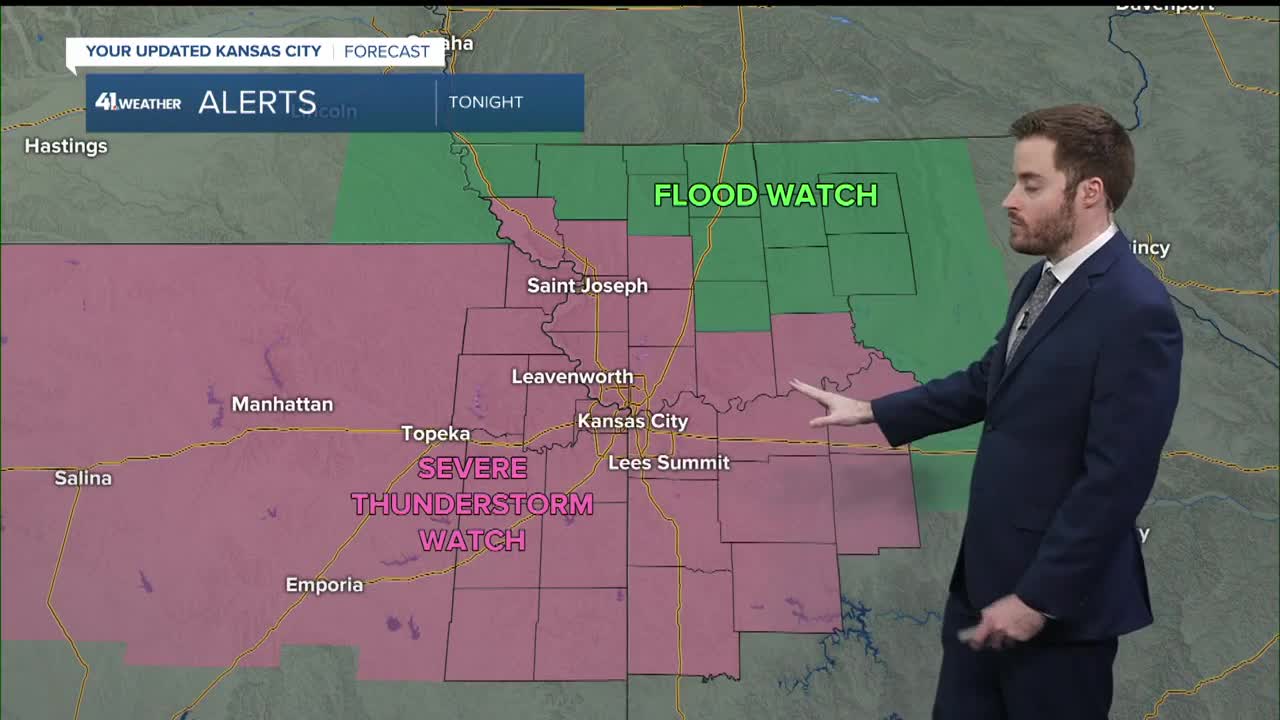
UPDATE, 10:30 p.m. | Here's the latest forecast update from Caleb Chevalier:
UPDATE, 9:10 p.m. | The National Weather Service has issued a severe thunderstorm watch until 4 a.m. Monday that includes the Kansas City area and points west.
7:50 p.m. | The Miami County Sheriff's Office released a statement on its Facebook page, saying more than 10 structures were damaged, ranging from minor damage to destroyed. No injuries have been reported as of this update.
The statement said multiple power poles and lines are still down, specifically in the area north of 255th Street and south of 239th Street along Pressonville Road.
As the storm moved throughout the county, "staff immediately began damage assessments and identified significant impacts, including damage to structures, power poles, and trees. Due to the extent of the structural damage, the Tornado Strike Team was requested, bringing additional fire and EMS resources to assist with the search and rescue operations."
The sheriff's office said sirens were activated in the northwest and central portions of Miami County, where there was a tornado warning. Siren did no go off in the the areas outside of the warning.
"We will continue to assess impacted areas while also preparing for a second wave of storms expected to enter the county this evening," the statement concluded.
6:15 p.m. | The Miami County Sheriff's Office says no injuries have been reported due to Sunday's storms.
6 p.m. | KSHB 41's Ryan Gamboa captured more damage in Miami County after storms hit the area Sunday.
5:40 p.m. | KSHB 41's Ryan Gamboa is at 247th Street and Pressonville Road in Miami County, where there are downed power lines after Sunday's storms.
5:10 p.m. | The tornado warning for parts of Johnson and Miami counties in Kansas, and Jackson and Cass counties in Missouri, has been canceled.
5:05 p.m. | Emergency management in Miami County is reporting roads under water and poles down near Pleasant Valley Road and Timber Lane.
5 p.m. | Parts of Johnson and Miami counties in Kansas, and Jackson and Cass counties in Missouri, are included in a tornado warning through 5:30 p.m.
4:58 p.m. | Law enforcement in Miami County is reporting two houses damaged and a barn totally collapsed at 247th Street and Pleasant Valley Road.
4:55 p.m. | The tornado warning that was issued in Linn County, Kansas, has been canceled.
4:45 p.m. | Several of the places hit in severe storms the last two weeks are reporting power outages from this afternoon’s storms.
About 1,000 customers are impacted in total, according to Evergy's outage map.4:40 p.m. | Parts of Linn County, Kansas, are included in a tornado warning through 5 p.m. Tornado warning for Johnson and Miami counties in Kansas to expire at 4:45 p.m.
4:23 p.m. | Parts of Johnson and Miami counties in Kansas are included in a tornado warning until 4:45 p.m.
3:52 p.m. | Parts of Johnson County and Miami County in Kansas are included in a severe thunderstorm warning through 4:45 p.m.
3:50pm--This storm will contain wind gusts up to 70 MPH!
— Wes Peery (@WesWeather) April 26, 2026
Severe Thunderstorm Warning including Overland Park KS, Olathe KS and Lenexa KS until 4:45 PM #kswx #kcwx #mowx pic.twitter.com/8qosvAwDmS
3:50 p.m. | The tornado warning that was issued in Douglas, Osage, and Shawnee counties in Kansas has been canceled.
3:30 p.m. | Parts of Douglas, Osage and Shawnee counties in Kansas are included in a tornado warning until 4:15 p.m.
3:25 p.m. | A tornado watch has been issued for the southern part of the KSHB 41 viewing area until 11 p.m. Sunday.
2:30 p.m. | KSHB 41's Wes Peery says a big line of storms is headed for the Kansas City area. There is mostly a damaging wind and hail threat, but we are also monitoring for a tornado.
12:15 p.m. | A severe thunderstorm watch has been issued for parts of Kansas and Missouri, including the immediate Kansas City area, until 7 p.m. Sunday.
KSHB 41's Wes Peery says storms will move into eastern Kansas around 2 p.m. and into Kansas City around 3 p.m., capable of mainly damaging wind and hail. A tornado can't be ruled out either, according to Peery.
12PM SUN-- A severe thunderstorm watch, including Kansas City, is in effect until 7pm
— Wes Peery (@WesWeather) April 26, 2026
Storms will move into eastern Kansas around 2pm Kansas City around 3pm, capable of mainly damaging wind and hail. A tornado can't be ruled out either. #mowx #kswx #kcwx pic.twitter.com/G9rf1AWdTq
11:50 p.m. | The start of Sunday's game between the Kansas City Royals and the Los Angeles Angels has been moved to 3:10 p.m. due to the potential for severe weather.
First pitch for tonight's game vs. the Los Angeles Angels has been moved up to 3:10 p.m. CT. pic.twitter.com/hgYajmB44k
— Kansas City Royals (@Royals) April 26, 2026
11 a.m. | KSHB 41's Jeff Penner says several rounds of rain and thunderstorms will begin later this afternoon and end early Monday morning.
Read more from Jeff in his weather blog.
—
![020626_KSHB_Image_NXA_Web_Standard Cube[88].jpg](https://ewscripps.brightspotcdn.com/dims4/default/0ead409/2147483647/strip/true/crop/300x225+0+13/resize/960x720!/format/webp/quality/90/?url=http%3A%2F%2Fewscripps-brightspot.s3.amazonaws.com%2F8f%2F6c%2Ffad8bd2346c5a4d4ead793017d4a%2F020626-kshb-image-nxa-web-standard-cube88.jpg)