

Good morning bloggers,
We haven't even had a dusting of snow before New Year's Day this season, and suddenly we have a major storm taking aim on Kansas City. A WINTER STORM WATCH has been issued for our entire viewing area. We are forecasting freezing rain, sleet, and heavy snow on New Year's Day.
Our Updated Snow Forecast:

There has been a trend on the models for the center of this storm to track just north of Kansas City. The above map will be updated as we get closer to Saturday, and as of right now we are forecasting freezing rain and sleet south of I-70, and mostly snow north of I-70. It may start as sleet and freezing rain north and then change to snow, and the precipitation will likely change to snow in most areas by Saturday afternoon.
This map shows the tight gradient from 1" of snow to potentially a lot more. Look at what the models are predicting as of early this morning:

These are the forecast totals for downtown Kansas City. There is less predicted just south, and a bit more just north. The new data is rolling in now. These numbers will change, and the track of the storm is still a bit uncertain. I will discuss the scenarios below.
What is the difference between freezing rain and sleet?
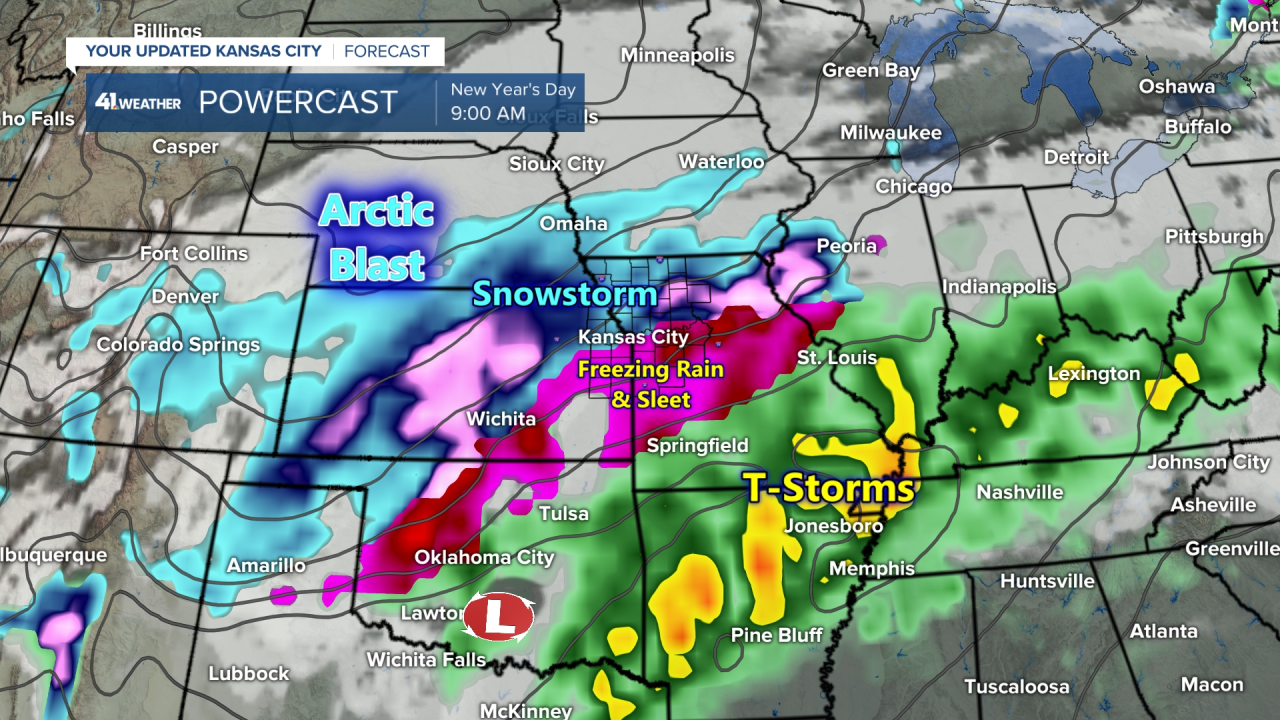
As you can see on this forecast map above, there is snow, shown in the blue and pink shades. And there is freezing rain and sleet, shown in the purple colors.
- Sleet: Sleet is frozen rain. Which means the rain drop or melted snowflake freezes into a small ice pellet. It is ice when it reaches the ground
- Freezing rain: Freezing rain is liquid all the way to the surface where it freezes on contact to surfaces that are 32 degrees or lower
Noon New Year's Day Forecast:


By noon, the American Model (GFS model) shows the sleet and freezing rain continuing southeast of a Harrisonville to Odessa line. This will cut into snowfall totals significantly. Farther northwest, however, this model changes it to heavy snow, which could be 1 to 2 inches per hour at times.
What we are tracking:
It has been raining in Los Angeles for 24 straight hours, and they are up to nearly 3" of rain from this storm system. This is a rather unusual storm. It is unusual because it didn't move in from the Pacific Ocean. It tracked straight down the west coast, staying offshore, and picking up moisture. It blasted Southern California as it was "diving" offshore.

This system developed off the Seattle coast, and then dropped south to off the Southern California coast this morning. This system is an important factor in whether or not Kansas City will have more than 1" of snow or not. The models pick this system up and race it our way after midnight Friday, just as we ring in the new year. The models then phase it into the flow, but maintain enough strength to create our areas of significant snow, sleet, and freezing rain. There is a main storm that is much larger that is kicking this system out.
What can go wrong?: If this system gets kicked out farther north and west, then warmer air would be drawn in above the surface and it would keep the precipitation type as freezing rain or sleet. So, we must keep monitoring for this possibility.
My instinct: I believe it will track just south of KC, and this will change the precipitation over to snow in time to put us into the ranges shown on our snow forecast chart. We will keep you updated as this approaches. So, I am thinking 4" or more up near KCI and 2" to 4" across the city. Jeff Penner has been predicting these totals all morning.
Winter Storm Timing:
- Now through Friday: Some mist this morning, and then a possibility the clouds break up this afternoon. Friday will have south winds ahead of the cold front and it will warm into the 50s
- Friday night before 2022: Cloudy with the colder air moving in. Temperatures will drop to 32 degrees after midnight, possibly into the 20s by 3 AM and it will likely stay dry.
- 3 AM - 9 AM Saturday (Happy New Year): Freezing rain and sleet begin south with snow beginning north of KC. The changeover line will gradually begin moving south. Temperatures will be crashing into the teens and roads will become slick & hazardous.
- 9 AM - 3 PM Saturday: The mixture will change to snow and it may become heavy. Accumulations of 2" to 4" in the city with 4 or more inches likely just north of KC. Slick & hazardous conditions in most areas.
- 3 PM - 9 PM Saturday: The snow may continue but it will gradually end from west to east by Sunday morning. Temperature will be dropping through the single digits, down to below zero by Sunday morning!
- Sunday: GO CHIEFS in Cincinatti. There may be a few snow showers with north winds in Cincy!
Thank you for sharing in this weather experience and spending a few minutes of your day reading the weather blog. We will go in-depth with KC's Most Accurate forecast on KSHB-41 News today and tonight as new data rolls in.
Gary
