


KANSAS CITY, Mo. — Good Thursday bloggers,
We are basically in a dry and unseasonably warm weather pattern. But, there is a two-day exception that arrives Saturday and exits Monday. Let's go through this.
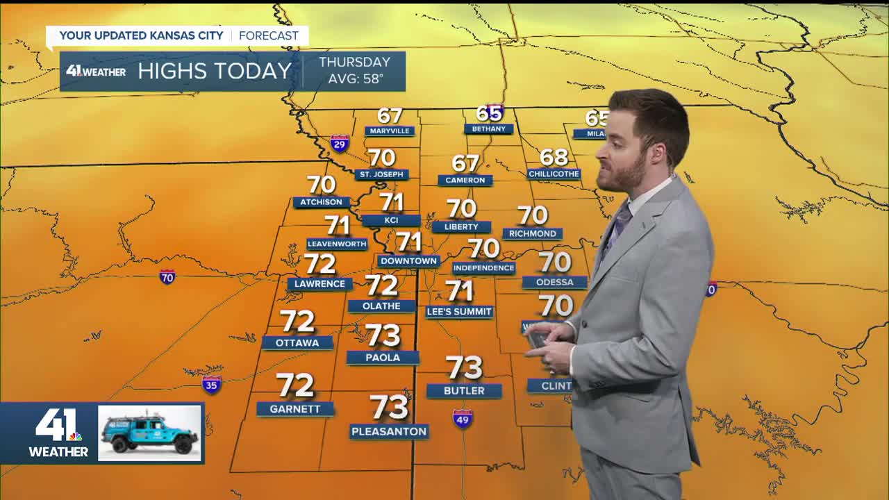
TODAY:
We will see increasing clouds with the chance for a few rain showers between 5 p.m. and 10 p.m. as a weak system and front move by. The showers will occur mainly northeast and east of Kansas City. Highs today will be around 70° with a south breeze at 10-20 mph.

FRIDAY:
It will be a fantastic Friday with highs again around 70°. The cold front to the north will track to Interstate 70 Friday night and stall as it waits for a storm system to form on it Saturday.

SATURDAY:
This is the day when we will see a change in the weather. It will be mostly cloudy with temperatures warming to the low 60s by noon. Then, a strong cold front will move in with a wind shift to the northwest, gusting over 30 mph, along with a temperature drop to the 40s. There may be a few rain showers.

This is the noon forecast map. It shows snow and rain tracking across Iowa and eastern Nebraska. The white arrows show where winds are gusting over 30 mph. We may get gusty southwest winds just ahead of the front.

1"-3" of snow is possible from the eastern Dakotas to Iowa to northern Illinois, mostly along and north of Interstate 80. If you are heading north on Interstate 29 or Interstate 35 this Saturday, keep this in mind as roads will be slick as you get to or just north of I-80.

If you are headed east on I-70 to Columbia, Missouri, for the Texas A&M vs. Mizzou game, it will likely be fairly nice for tailgating and kickoff. But, during the game, the strong cold front will surge through. It does not look like much rain with the front, perhaps a brief shower.

SATURDAY NIGHT:
It will be windy and cold as temperatures drop through the 30s into the upper 20s with wind chill values dropping to the 20s and teens. The wind will be north-northwest 15-30 mph. A small disturbance from the north may bring a sprinkle or even flurry. If there is a flurry you may need a magnifying glass to see it and don't blink.

SUNDAY:
It will be mostly sunny, but highs will struggle to 40° as north winds gust to 20-30 mph. It still looks cold for the KC Current game that starts at 11:30 a.m. The wind chill will be in the teens and 20s.

SUNDAY NIGHT:
It will be clear with a light wind, allowing temperatures to tank to the upper teens and low 20s.

MONDAY-WEDNESDAY:
You will be saying, what cold air? After a high in the 40s Monday, it will jump to the 60s Tuesday and Wednesday. There are signs we will see highs in the 70s by the end of next week. Tuesday may be mostly cloudy, but it will be sunny Monday and Wednesday. And of course, no precipitation.


RAINFALL FORECAST NEXT 7 DAYS:
Total rainfall around here will be a trace to .10", which includes the rain chance today and this weekend. There is a slight chance to see a wetter storm during the weekend of the 15th. This dry weather is only going to worsen our drought conditions, and we just do not see much precipitation in the forecast.

Have a great rest of your week and weekend.
Stay healthy
