


KANSAS CITY, Mo. — Good Halloween Friday bloggers,
Before we look ahead, let's look back.
First, let's look at the latest Drought Monitor. We are currently and firmly in a Severe drought, which is a level 3 of 5. The rain we had for six straight days was nice to see, but the amounts were mostly under an inch, and did not do much to knock down the drought.

There are drought conditions from the Ozarks to Ohio, but recent rainfall has knocked this down a bit.

There are three main zones of drought from Florida to Maine, the Ozarks to the Great Lakes and south Texas to west of the Continental Divide. Nearly half of the country is in at least a level 1-4 drought.

We have seen just three of the 10 months in 2025 with above-average rainfall. July was 200% of average, which helps the numbers, but we are 7" below average rainfall since the end of July. So, it is no secret why we are in a severe drought.

October has been an odd temperature month. October 1-18, we were sitting at the second warmest October in history, where records started in 1888. Since the 18th, we have dropped to the 17th warmest as we have seen seven straight days with highs in the 50s, which is about 5-8 degrees below average. Today will be an 8th straight day in the 50s, although we could touch 60°.

Now, let's look ahead.
TODAY (NOON-MIDNIGHT):
We are tracking a weak system from the west-northwest and one from the north today-Saturday.
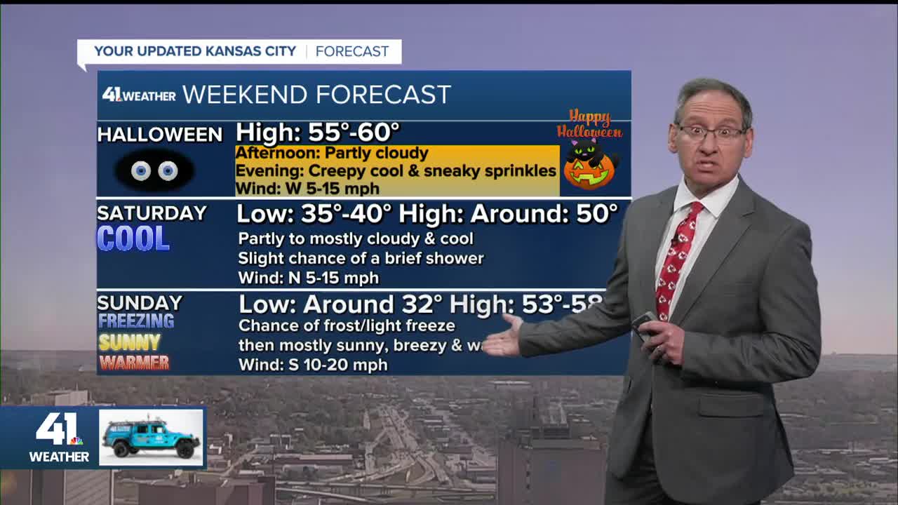
Clouds will increase this afternoon & a few light showers/sprinkles will be possible after 8 p.m., mostly south & west of Kansas City. Also, the green on the map representing the showers may be a bit overdone. So, this is the small possible trick to track. Highs today will be 55°-60°, dropping to the low 50s & upper 40s for trick or treat time.

TONIGHT-SATURDAY (MIDNIGHT-7 AM):
The sky will clear as the first system moves away. Lows will drop to 35°-40° & there may be more patchy frost.

SATURDAY (7 AM-7 PM):
The system from the north will track south, to the east of our region. This means we will see a lot of clouds, with some brief sun, along with highs around 50°. There will also be a few showers across central & eastern Missouri, with a few possibly sneaking west to the state line.

SATURDAY NIGHT:
We are in a freeze watch, which would be right around the average date for our first freeze. Lows will be around 32° as the sky clears and the wind is very light, which sets up ideal nighttime cooling conditions. This is also called "radiational cooling."


Also, Saturday night, remember to set your clocks back one hour and check the smoke alarm batteries. This makes this weekend a 49-hour weekend, and the weather data will come in one hour earlier. I know everyone is excited about the early weather data. LOL.

SUNDAY:
After the cold start, it will be mostly sunny with an increasing south wind. Highs will still be in the 50s as the 60s/70s build out west.

MONDAY:
The 60s will surge in and be with us nearly every day next week. A few days may reach the low 70s, especially Tuesday.

NEXT WEEK:
The systems will move fast from west to east. They will have a hard time picking up moisture from the Gulf before they reach our region. So, this is why the best rain chances next week are east of our region. There is a system a the end of next week that could slow enough to bring some rain here, we are on the western edge as of now. Even in locations that get rain, amounts will be light as the systems are mostly weak.
Temperatures will run 5-15 degrees above average. Our average highs drop to the upper 50s with average lows in the upper 30s. So, yes, that means highs will be in the 60s to low 70s with lows mostly in the 40s.

WEEKEND WEATHER FORECAST SUMMARY:
There is a slight chance for sprinkles and a few light showers this evening, mostly south & west of Kansas City. A few showers are possible Saturday, mainly east of Kansas City.

KSU/KU FOOTBALL FORECASTS:
If you are heading to these games, the forecast is very similar as they start 30 minutes apart. Basically, it will be partly to mostly cloudy with a light north breeze and temperatures around 50°.


Have a great weekend & safe Halloween
Stay healthy
Please do NOT drink/text while driving. This is in memory of all of those who have been injured or killed in drinking/texting while driving accidents. Nathan Mcduffie lost his life in a drunk driving accident around 35 years ago.
