


Good Wednesday, bloggers,
It is going to be a while before we enjoy temperatures in the 50s and 60s, as we are tracking four more cold fronts over the next 7 days. The first one came through last night.
Our average temperature this month, through the 13th, is sitting at 40.5° when you average the high and low temperatures. This is 11.4° above average and ranks as the third-warmest January on record, so far. The next four cold fronts will have something to say about that.
Keep in mind that Jan. 10-23 are on average the coldest days of the year with an average high of 38° and an average low of 19°. By Jan. 31, the average high rises to 40° while the average low rises to 20°.

Let's go through this.
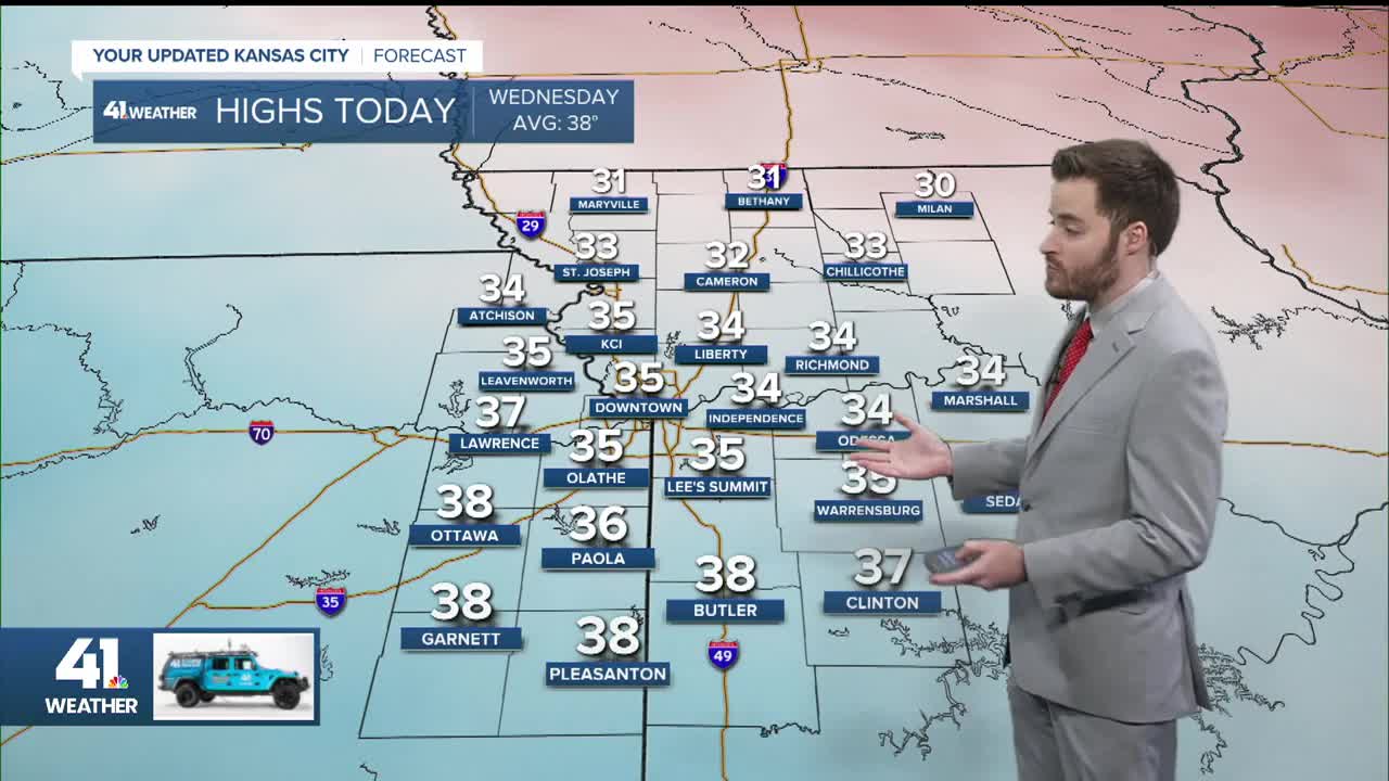
TONIGHT-THURSDAY:
The front last night brought average cold. Our low tonight will be 18°-20°, and our high Thursday will be in the low 40s.
This is actually a tad above average.

A warm front will be approaching Thursday with highs in the 50s/60s in western Kansas.
But the second front will be racing south from the Dakotas, pushing the 50s/60s south before they have a chance to get here.
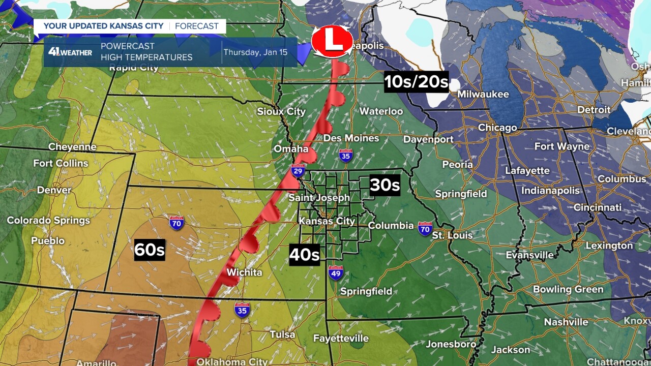
FRIDAY:
The first cold front will have raced south and east as the second one races in from the north. We may see some flurries/snow showers with these fronts.
We will talk more about snow with this cold below.
Also, notice the Arctic air getting to Interstate 80.

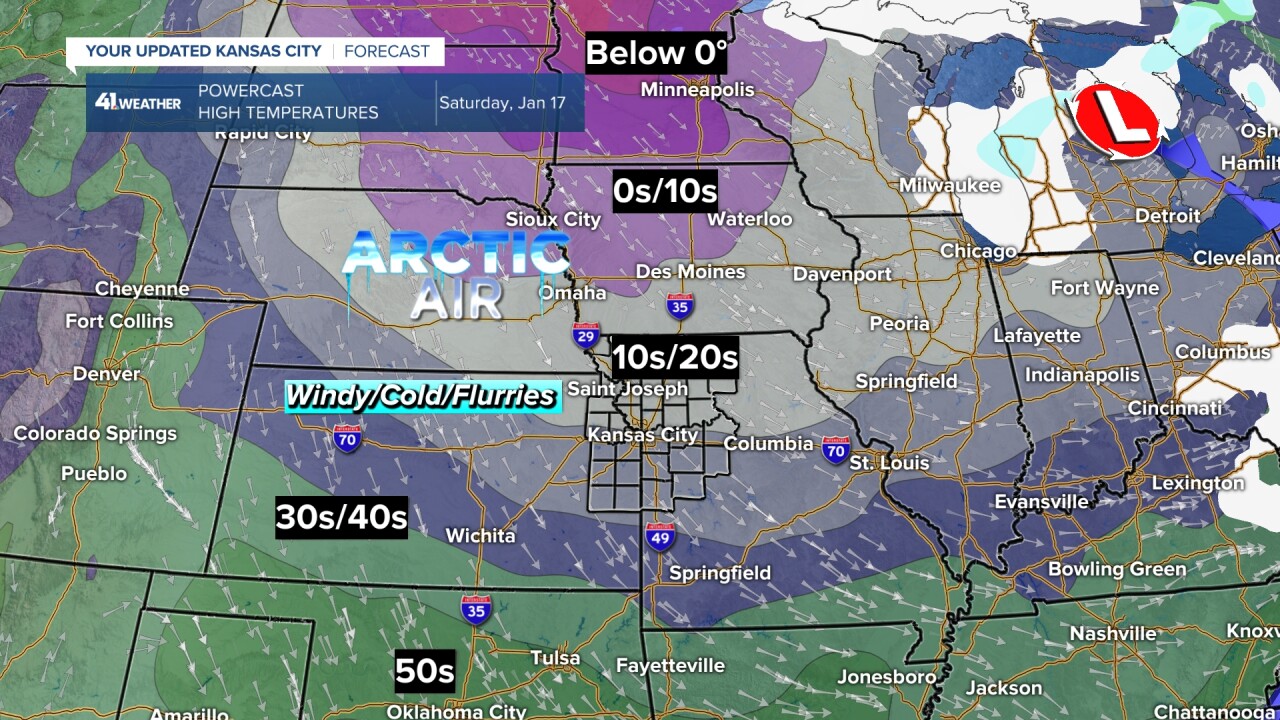
SATURDAY:
Eek! The second cold front raced through early Saturday, and now the Arctic air is rather close.
Right now, we are going for a high around 25°, but we could easily see temperatures drop to the teens with wind chill values as low as -10°.
The wind will be from the northwest at 15-25 mph, along with the chance of flurries and snow showers. The ground could get dusted white in a few locations.
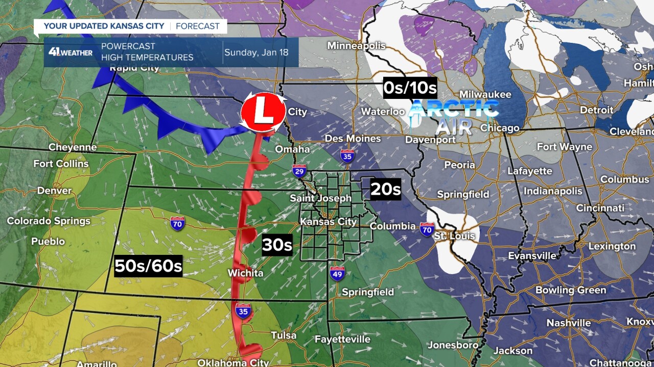
SUNDAY:
Lows will be around 10° with wind chill values around zero.
The third cold front will be racing south as a warm front pushes east. But, just like Thursday, the warmer air to the west will not get a chance to make it.
We will see highs try to get to freezing.
The fourth cold front is due Monday, and possibly a fifth on Wednesday. These will act like their predecessors, meaning the warmth to the west will not get here, and we will flirt with Arctic air for about 12 hours, along with the chance of flurries.
SNOW/RAIN FORECAST NEXT 10 DAYS:
Now, where will snow occur with all of this cold?
The quick answer is not in most locations west of the Mississippi River, except North Dakota and Minnesota. There may be a heavy rain event in southern Texas.

Back to the snow east of the Mississippi River. Let's take a closer look.
1"-4" of snow is possible from North Dakota to Illinois, Indiana and Ohio, with much higher amounts in the lake-effect areas.
Now, look south. There is a chance to see 1"-3" of snow from New Orleans to the Florida panhandle to Georgia this weekend.
One, this did happen last year, remember the 4"-8" snowstorm last year between Jan. 20-22? Heavy snow occurred from Houston to New Orleans to southern Georgia. Two, at this time, the American model is the only one showing this solution. So, it is far from being set.
If this storm does occur, it could lead to a big Nor'Easter from New York City and north. Again, this is the only model as of noon Wednesday doing this. So, still many questions.
When will we see a chance of snow? There will be 2-4 chances between Jan. 23 and Feb. 20. One of the chances could be ice.

Have a great rest of your week and weekend.
Stay healthy.
—
