


KANSAS CITY, Mo. — Good Tuesday, bloggers,
It is no secret that we need rain. Since the end of July, most locations have been 25% to 50% of average or less.
What is amazing is that since July, it has been almost nonstop rain from Nebraska to north Texas, just west of our area. The rain out there has been tracking toward us, but then mostly falls apart before it reaches our area, or it simply misses our area.
Yesterday was Exhibit A on this rainfall pattern.
Our area did not see a drop, while locations west of Salina received 3"-12" of rain. There are still flood warnings out there.

Well, today we have rain and thunderstorms heading this way. And it looks like it will make it to at least some very dry locations.
As of 5:30 a.m., there was a line of rain and thunderstorms from just north of Manhattan, Kansas, to south of Omaha, Nebraska.
This should hold together in some form as there is an upper-level disturbance associated with it, and there is a feed of Gulf moisture following it around 3,000-5,000 feet.

NOW-NOON:
We will see the rain and thunderstorms progress southeast into eastern Kansas and western Missouri.
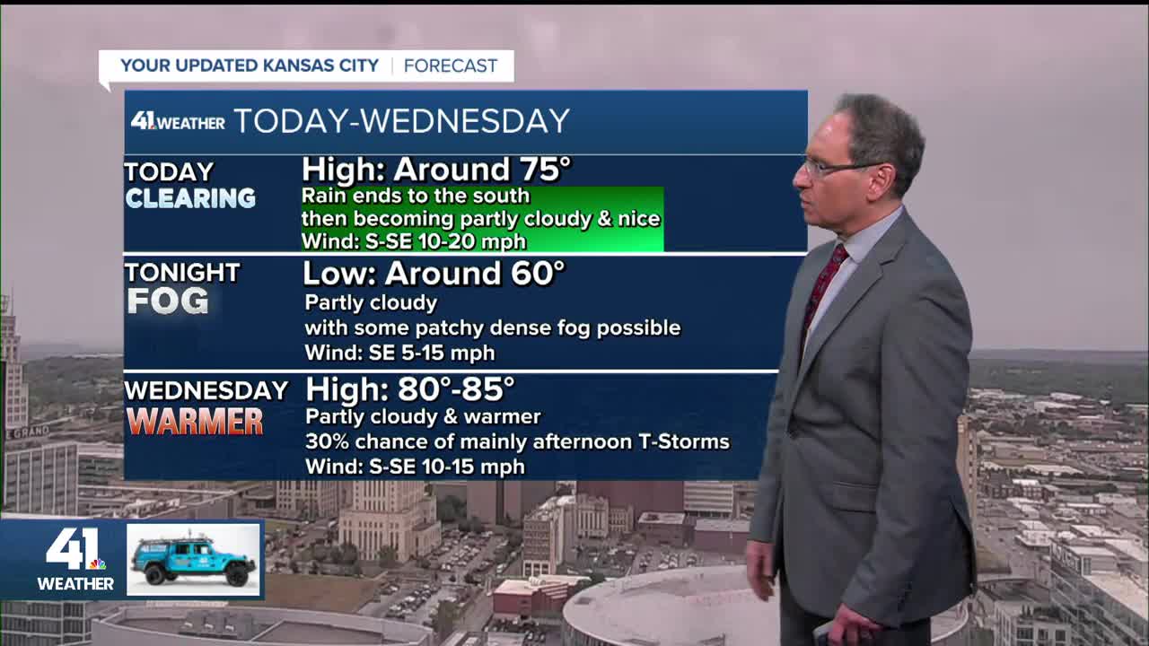
In areas where there's rain, temperatures will be in the 60s. It will warm to the 70s where it does not rain.

NOON-4 PM:
The rain will exit and the clouds will slowly break up.
Highs will be in the mid to upper 70s where the sun comes out. Highs will stay in the upper 60s where the clouds hang tough.
Tonight, with a clearing sky and light wind, the conditions are there for patchy dense fog.

There is a slight chance of thunderstorms on Wednesday with a new disturbance, but the rain chances are quite low or zero for about five days after Wednesday. Those dry days will be hot as well with highs around 90°.
RAINFALL FORECAST TODAY-WEDNESDAY:
This system will bring a 20-30 mile wide 1"-2" rainfall zone and a 20-30 mile wide 0.25"-1" rainfall zone around the heaviest rain. Outside the 0.25"-1" rainfall zone, amounts will be trace-0.25" or zip.
This data has the heaviest rain from around Seneca, Kansas, to Butler, Missouri. This heaviest zone can still shift northeast or southwest by 15-30 miles at the last minute.

WEATHER SUMMARY:
Fingers crossed it rains on your yard or farm.

Have a great rest of your week!
Stay healthy.
—
