


KANSAS CITY, Mo. — Good Wednesday bloggers,
The last 24 hours of data have been rather interesting: There has been a significant shift north on the American model and some other south models. They are joining the Euro model, which means we are now likely to have accumulating snow with the dangerous cold.
On Tuesday, we showed how the American model was not as organized in picking up a southern storm as the Euro. Well, the American model is now looking more organized and the Euro has changed little.
There are two main pieces of energy we are tracking. One is a decent upper low off the coast of southern California coast, and the second is rather innocent-looking northwest of Alaska.
Between today and Saturday, the system northwest of Alaska will track east into northwest Canada and then south into the Rockies. The southern, moisture-laden system off the southern California coast will track east-northeast into Texas. These two systems will combine in the Plains as a large Arctic air mass heads south. The storm system will induce warm and moist air to track north from the Gulf, which will overrun this huge Arctic airmass.
This is a recipe for a variety of precipitation.

The structure of the atmosphere from Texas to the southeast USA is set up for freezing rain, sleet and ice. There is an above-freezing layer of air sandwiched between below 32° degree air above and below.
Freezing rain is the precipitation type that brings down power lines, as it is liquid water that freezes on contact with the surface. Sleet is a frozen raindrop as it falls through a smaller layer of above 32° degree air and the raindrop has time to freeze. It just bounces and does not glaze.
The airmass over our area is all below 32°, so we will see all snow.

Now, to our latest thinking on this storm. We will look at the big picture first, then look closer to our area.
It begins on Friday and ends on Sunday. It may come in two waves. The first will be Friday afternoon into early Saturday.

There may be a lull in the precipitation on Saturday. The reason I haven't moved the "Major Ice Storm" and "Snowstorm" text is that part two is around the corner.

Saturday night and Sunday look like the main show of the storm. You can see the northern edge of the snow is now Interstate 80.

So now the 10"-15" snow band is to northern Oklahoma/Arkansas, even as far as southern Missouri. It still looks like there is a large area to see an ice storm. The area that has the best chance to see a devastating ice storm, from 1"-3" of ice on everything, is central Texas to northern Georgia.

Now let's take a closer look at our area.
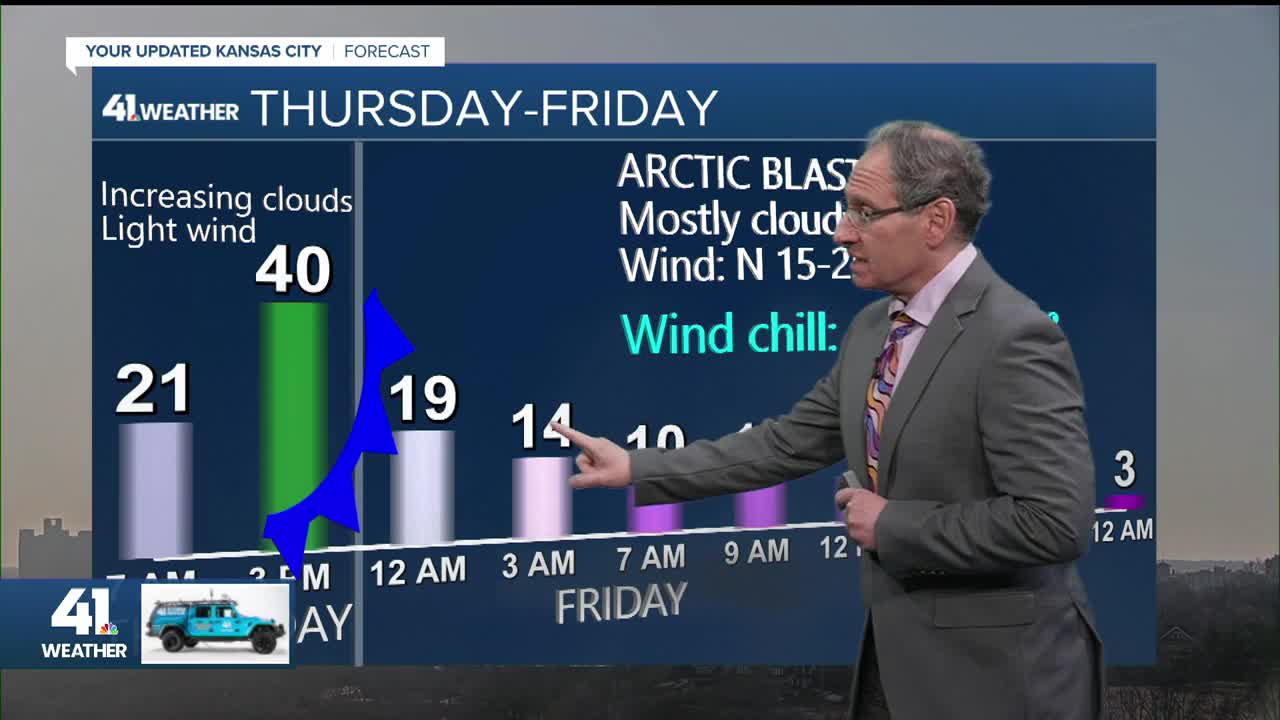
THURSDAY:
Highs will be around 40° as the Arctic air approaches I-80.

FRIDAY:
The Arctic air will arrive Thursday night, so we will see temperatures in the single digits all day with wind chill values -25° to -10°. Snow will start forming in western Kansas. Our area will be mostly dry.


FRIDAY NIGHT:
Snow will likely move in with temperatures around 5° and wind chill values around -25°. The snow will stick to all surfaces from the very first flake.

SATURDAY MORNING:
We may see a lull in the snow where the intensity becomes very light or even stops. Temperatures will be around 0° with wind chill values around -20°. The wind may not be that strong, north 10-20. But, when it is 0°, the wind chill is around -20°.

SATURDAY AFTERNOON:
The second wave of snow, the main event, will likely approach as highs struggle to 10°. This map shows 11°, but that may be 5 degrees too warm.

SATURDAY NIGHT:
We are fully in wave two, with steady light to moderate snow, heavy at times, at 5°-10°. Again, the wind may be north at 10-15 mph, so we should not have to deal with blizzard conditions. But wind chill values will still be -25° to -5°. You can see some ice has sneaked into southeast Missouri. Something to watch.

SUNDAY:
The snow will end around noon with temperatures again struggling to 10°. We may see actual temperatures as low as -10° Monday morning.

SNOWFALL FORECAST:
It is still too early for specific numbers, but we can say the low end is in the dusting-2" range. And the chance to see 3" or more is around 75%-85%.

WEATHER SUMMARY:

Stay with KSHB 41 and we'll keep you advised.
Have a great rest of your week
Stay warm
Stay healthy
