


KANSAS CITY, Mo. — Good Red Friday bloggers,
The heat has arrived as the high Thursday was 91°. The heat will be with us for about the next week. This also means rain chances will be few and far between over the same time period.
Rainfall during the last 30 days, and really since the end of July, has been paltry.
We average 4.00"-4.25" of rain during the last 30 days. The percent average rainfall is under 10% east of Kansas City, 15% to 30% around Kansas City, and 50% to 105% west of Kansas City. Yes, there has been plenty of rain from west of Maryville, Missouri, to Topeka, Kansas, to west of Ottawa, Kansas.
Emporia has seen 104% of average rainfall, while Marshall, Missouri, has seen 5% of average rainfall.

When you widen out the view, you can see the very dry conditions are centered in Missouri, as rainfall percent of average is in the 5% to 15% range. Central and western Kansas are in the 100% to 300% of average range. It has been a weird rainfall pattern.

This rainfall pattern has led to severe drought conditions in southern Missouri, which is a level 2 of 4 drought on the latest drought monitor that came out Thursday. It was way too wet down there during the spring, certainly odd. Nebraska and Kansas have patchy minimal drought as they have seen regular rainfall.

Our area is mostly in the yellow color, which is one rung below a level 1 drought. It is called the "abnormally dry" category. Now, moderate drought (level 1 of 4) conditions have shown up across Wyandotte, northern Johnson and southern Leavenworth counties.

Drought conditions across the USA are in the western USA and from Arkansas, Missouri into the Tennessee Valley and eastern Midwest. You can see the areas that have seen rain in the little to no drought areas from the Dakotas to Texas to Wisconsin.

Rainfall the next 5-7 days will be falling in areas that have seen rain, while areas that need rain will not see much.

The upper-level flow is what controls the weather at the surface. The upper level flow today and Saturday features a building upper level high, heat dome, heat wave creating machine from Texas to the Midwest. This feature is the opposite of a storm system, so the dry areas stay dry.

The upper-level flow for Chiefs Sunday will see the heat dome get pushed east as a storm system tracks north across the Plains. This means the best rain chances stay west and the least to no rain chances stay east and Kansas City is right near the border of the wetter and drier areas. Now, we have been mostly in the dry areas. It looks like this will hold through Chiefs' Sunday.

When will this change? There are signs by the middle to end of next week as a system from the western USA tracks east, squashing the heat dome to the south. Locations east of the Mississippi River may still be under a weak version of this dome until after Sept. 21.

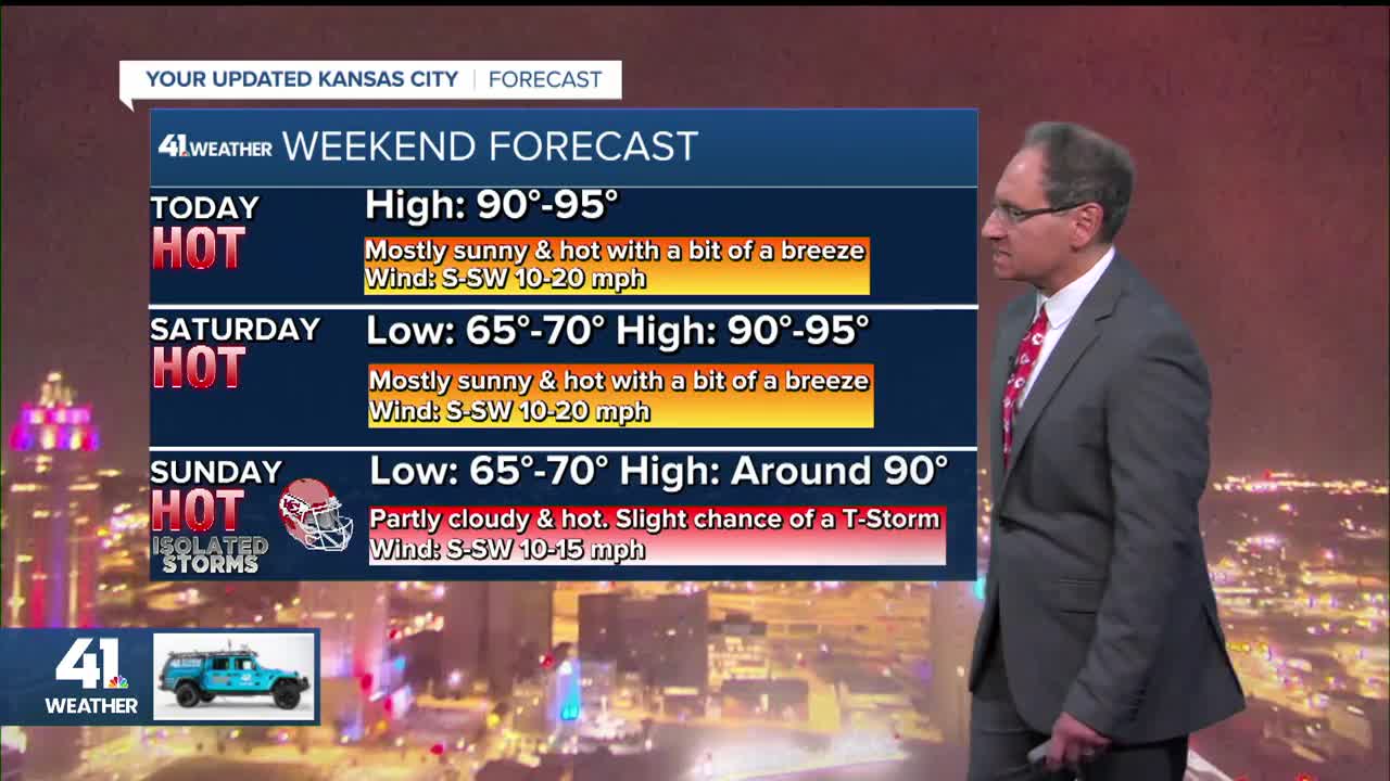
Let's take a look at the weather through the weekend.
FRIDAY:
The best chance of T-Storms will be across Minnesota and Wisconsin as we warm to the low and mid 90s. A south breeze at 10-25 mph will help a tad.

SATURDAY:
This looks like the hottest day of this heat stretch as highs here will be closer to 95° than 90°. A south breeze at 10-20 mph again will help a tad. You can see the T-Storms go from the western Plains to the upper Midwest, right in the areas that have been seeing the rain.

Mizzou moved the game on Saturday from 3 PM to noon due to the heat. This will help a bit as it may knock off two hours of being out in the extreme heat. But, the game would have to be played at night to really avoid the extreme heat.
It will be 91° by kickoff on the way to a high around 95°. In the sun you can add 5-10 degrees to these numbers.

CHIEFS SUNDAY:
It will also be hot out at Arrowhead as highs reach around 90°. There will be a lot of clouds and this may help some, but most of the clouds will be cirrus. The sun will be able to shine through the cirrus, which are high clouds. Also, there is a slight chance of a T-Storm, but since we are in the same rainfall set up most rain will stay to the west.

You can see the T-Storms from the Texas panhandle to Minnesota and Wisconsin, look familiar? A T-Storm or two may sneak into eastern Kansas and western Missouri. It will be the middle to end of next week when we will see a better chance of meaningful rain and a meaningful drop in temperature.

Have a great weekend
Stay healthy
GO CHIEFS!
