


Good Tuesday, bloggers,
It is no secret that we need rain, as there are many locations that have seen under 10% to 25% of average rainfall since the end of July.
We've averaged 4"-4.25" of rain since the end of July. This means many locations have received under 0.50"-1" of rain.

We are tracking a main storm system and disturbance through Friday that will increase the chance of rain around our area, but it may be a struggle to get widespread rain.
The main storm system is located in the northern Rockies. It will track east across the Plains during the next three days.
The system will help create numerous areas of rain and T-storms across the Plains into the Midwest. But as the areas track east, the coverage of rain will decrease, which has been happening since the end of July.
Ahead of the main system, there is a long and thin north-south disturbance located from southern Canada to Louisiana, just east of KC. This disturbance has been producing some thunderstorms and is slowly drifting west.

During the last 24 hours, you can see a long, thin, north-south band of rain in central and eastern Missouri, where 1"-2" of rain fell from east of Kirksville to near Rolla. This disturbance will be in far western Missouri today.

Last night, between 9 p.m. and midnight, there was a small cluster of thunderstorms that produced 0.50"-1" of rain across Kansas' northern Miami and southwest Johnson counties.

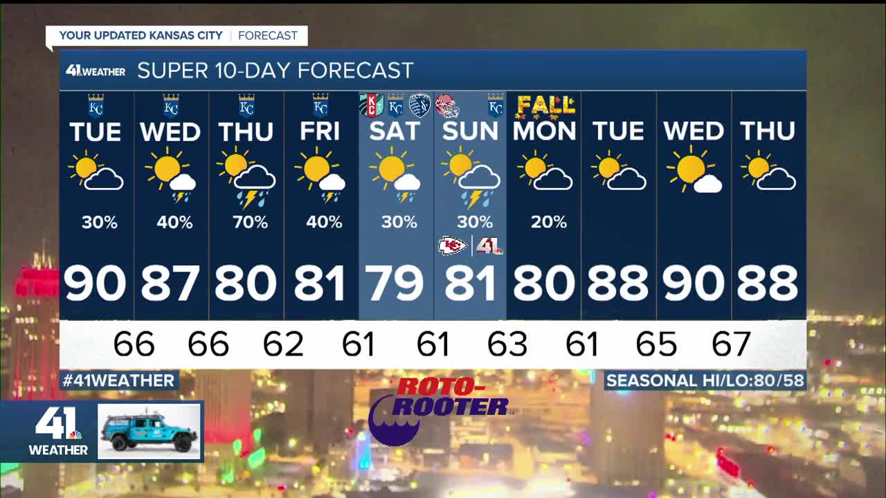
TUESDAY:
The thin, north-south disturbance will generate a zone of thunderstorms from western Iowa to western Arkansas, near KC. This band could shift 30-50 miles west or east.
Highs today will be around 90° with a light wind.

WEDNESDAY:
The day will start with a few showers and thunderstorms possible, with lows 65°-70°.

During the afternoon, we will see areas of rain and thunderstorms in locations that have been seeing plenty of rain — the Dakotas to Oklahoma and western Iowa.
We will see some of those thunderstorms, but they will weaken as they get here. Highs tomorrow will be 85°-90°, still steamy.

THURSDAY:
This is the day when we may be more in the zone where higher coverage showers and thunderstorms form. It still does not mean widespread rain, but more widespread than today and Wednesday.
Highs will cool to around 80° due to more clouds.


FRIDAY:
The main zone of scattered thunderstorms will be shifting to the east as highs climb to around 80°.

RAINFALL FORECAST TUESDAY-FRIDAY:
There will be widespread 1"-4" rainfall totals from the Dakotas to central Kansas, Iowa and Minnesota. These are areas that have seen regular rainfall since the end of July.
So when you add up the rain each day between today and Friday, you get the total amounts seen in the map below.
Our area will see 1"-3" in northwest Missouri, which has seen some decent rain to under 0.50" south and east of KC. So this puts KC in the 0.10"-1" rainfall zone.
We need more than this, but it is better than nothing. There is always a chance more widespread rain areas shift south and east.

Have a great rest of your week.
Stay healthy.
—
