


KANSAS CITY, Mo. — Good Wednesday bloggers,
The 1st 10 days of this March have been wild. "March Weather Madness" is an understatement. Before we look ahead to the next wild weather change let's look back at the first 10 days of March 2026.
MARCH 1ST:
Thundersleet, rain and freezing rain. We were 0.5° to 1° away from an ice storm.

MARCH 2-5:
Overcast most of the time with periods of rain and temperatures in the 40s/50s
MARCH 6:
We had several rounds of thunderstorms with rainfall of 1"-3" on the south side of KC. Then, between 1134 PM and 1145 PM and EF 0 tornado tracked from Shawnee to Westport knocking down trees, one of which caused considerable damage to a house.

MARCH 9:
We reached 78° breaking the record high of 77° set in 2021/1986
MARCH 10:
Wow! What a day. We reached 83°, 1 degree from the record set in 1967. It reached 86° downtown, but our records are kept at KCI airport. But, March 10th still had more to offer.
6-8 PM a cold front helped to generate severe thunderstorms from northwest Johnson county to Clay county. Baseball sized hail was common.


Then, 8 PM to midnight a neatly stationary line of strong to severe thunderstorms affected Johnson and Jackson counties with numerous reports of quarter-sized hail and 1"-4" of rain.


During the last 7 days look at the rainfall amounts across the region. 4" to 7" amounts are quite common from southeast Kansas to Indiana. There are some 8"-9" amounts in there as well. KC was on the northwest edge of the heavy rain. If you live northwest of KC, you are probably wondering what I am talking about. Rainfall has been .10"-1" and without much or any severe weather.


Now, this March has another trick up its sleeve for Sunday into Monday, March 15-16. Let's go through this.
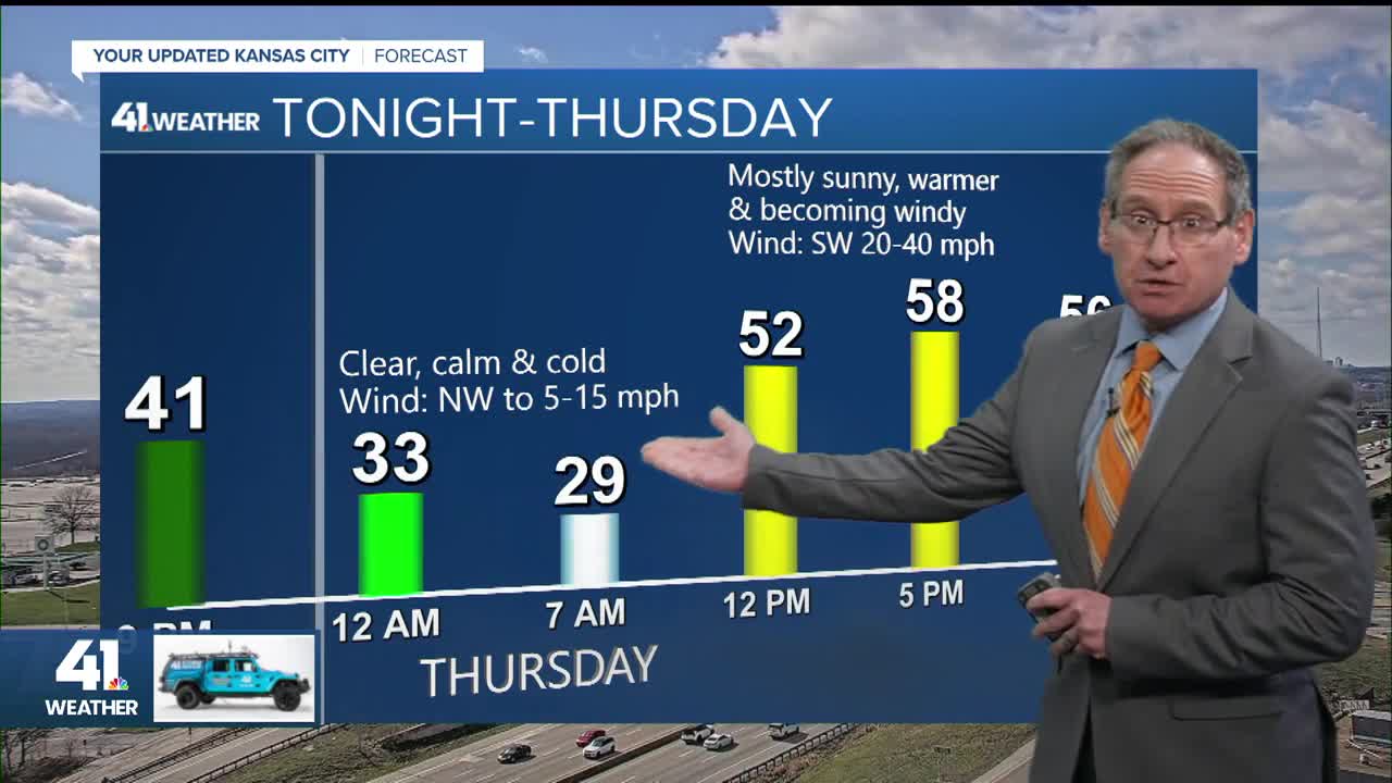
THURSDAY:
A warm front will move through with a few clouds. But, the wind will become southwest 20-40 mph during the day, lasting into the night. And in locations that have not see much rain, like northeast Kansas and northwest Missouri, there is a Fire Weather Watch. We will get close to 60°.

FRIDAY:
This is a calm day as a weak cold front drifts south. We will be partly cloudy with highs in the 50s and a light north breeze.

SATURDAY:
This will be a nice day as highs climb to the 60s with a south breeze 10-20 mph. But, lurking to the north is a very cold airmass.

SUNDAY:
The cold front will surge in during the morning as a storm system tracks into the Plains. We may start the day in the 50s.

SUNDAY (NOON):
But, by noon we will be dropping into the 30s and low 40s on north winds 20-40 mph. And yes, something we have not seen this month yet, snow, is extending south into central Kansas on the back side of the storm.

SUNDAY (3-7 PM):
Uh oh! We may see a period of snow as temperatures head to the low 30s and upper 20s. The only way we see accumulation on all surfaces is if the snow comes down hard enough and long enough and mostly after sunset. It would stick to most surfaces, especially grassy surfaces, during the day if it comes down hard enough and long enough. Right now, the chance of seeing accumulation is about 20% as the storm needs to track farther south to put us in the more substantial snow.
There has been a slight trend south on the storm. Something to watch closely.


MONDAY MORNING:
OUCH! Regardless of whether we see snow or not, the very cold air will surge in. Lows Monday look to be in the teens with single digits near the Iowa border.

The battle between winter and spring that occurs every March is in overdrive for 2026.
Have a great rest of your week and weekend
Stay healthy
