


Happy Sunday and Cinco de Mayo, blog readers —
Wow! What a beautiful day we've got on tap!
Downtown will get close to 70° for Cinco de Mayo celebrations — just expect a few more clouds this afternoon. But overall, it'll be a nice quiet close to the weekend.
The sunrise today is gorgeous and the weather today... well it looks pretty gorgeous to me! Overall, it will be a really nice close to the weekend but storms are brewing tomorrow! @KSHB41 pic.twitter.com/bsJACR8lhF
— ☀️ Cassie Wilson (@CassieKSHB) May 5, 2024
Monday, a stormy pattern sets up. Our severe weather risk Monday is the highest with lingering severe weather concerns into Tuesday and Wednesday.
I think Tuesday's setup has the chance to completely fall apart for us, and Wednesday should stay south and east of the metro.
Let's focus on Monday and the risks ahead!
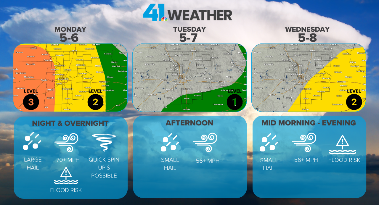
Monday impacts
The good news about Monday's forecast is that we will see storms fire in central Kansas, be able to watch them closely and really be able to track the timing out for the metro.
The bad news about Monday is this could be a significant severe weather day for areas around Wichita south through Oklahoma. This is where we see a Level 4 risk with significant tornado, wind and hail risks.


For Kansas City, our tornado risk is sitting at 10% for a small portion of our Kansas counties: Atchison, Jefferson, Douglas, Franklin and Anderson.
The rest of our area is sitting under a 5% risk of seeing a tornado within 25 miles of your home.
The tornado threat for our area will be focused on quick spin-ups along the line of thunderstorms — really as they first start to make impact.
These types of tornadoes can produce quick 90-100 mph winds and can cause some damage.

Kansas City's main threat will be wind damage and powerful winds as this line of thunderstorms moves through our area. This places our severe window to around 8 p.m. through 2 a.m.
Winds in excess of 70 mph will be possible as this line first kicks up trouble. But the line should weaken quickly after 2 a.m. as it moves into central Missouri.

Monday timeline
Honestly, we are going to enjoy a lot of the day on Monday here in Kansas City. Temps get a boost near 80°and skies will open up to sunshine through the afternoon.

But through the middle of the day, we will be tracking storms starting to fire in central Kansas.
Here is what models are trying to spit out by 4 p.m. Monday.

The majority of the intense severe weather will stay in central Kansas and Oklahoma during the afternoon and early evening hours. This line looks to make it to KC by sundown.
Here is what the radar could look like by 9 p.m. Monday.

Right now, our severe window for metro counties (Johnson, Wyandotte, Platte, Clay and Jackson) looks to be between 10 p.m. and 2 a.m.
But like I noted earlier, we will have a really good track on this line all day, and we will have you covered through it all.
Make sure to stay up to date with the forecast as you move through your Monday. Severe weather concerns for Tuesday are really low on my radar, but it depends on where the front stalls out. Then, it turns a bit stationary into Wednesday.
Wednesday, the storm risk should stay east of Kansas City, and right now, we are forecasting a beautiful day for School Day at the K.

Pssst — it's not too late to get tickets!!!!!
—
