


Have a weather question for Lauren? Send her an email.
—
Winter looks to be taking aim on the Kansas City region this weekend with snow and dangerous cold on the menu.
First, let's discuss the dangerous cold.
After a decent Thursday, arctic air will push into the Kansas City area late Thursday night into Friday morning.
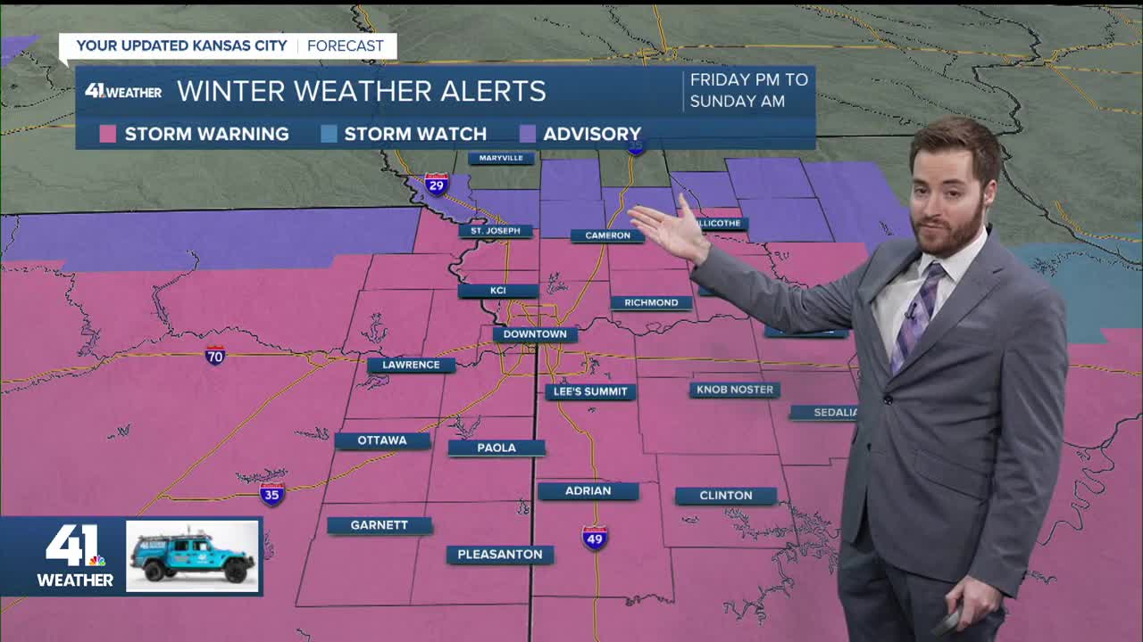
Cold weather alerts are posted Thursday night through Friday. Friday morning wind chills as low as 25 degrees below zero are forecast from Chillicothe, to Milan, Bethany, and Maryville. Most of the Kansas City area will wake up Friday with single-digit temperatures and sub-zero wind chills.

Each morning through Sunday, expect sub-zero wind chills. Temperatures on Friday and Saturday afternoon will struggle to reach the double-digits.
With the downright frigid air locked in place, any snow that falls will instantly stick.
Speaking of snow... Let's go over the timeline.

The bulk of Friday will feature bitterly cold, cloudy conditions. By dinner time, we'll look to our west, as the snow will be on our doorstep. Expect snow to move into the Kansas City area, from west to east, mainly after 7 p.m. The snow on Friday evening will initially be light before increasing in coverage and intensity Friday night into Saturday. Expect snow most of the day Saturday. A second wave of snow will likely move in Saturday night into Sunday. The snow will diminish from west to east by Sunday afternoon.
The snowfall forecast continues to trend upward. The two main factors we've been monitoring are the track of the low and the amount of dry air in place. The latest forecast data suggests that enough moisture will work northward, with a more north track of the low; this would lead to much higher snowfall amounts than initially forecast.

Unlike most snowfall events, this one will highlight areas south of Interstate 70 and U.S. Highway 50 to receive the most snow. A general rule of thumb with this weekend event - The more south of I-70, the more snow. The further north of I-70, less snow. There will be a sharp gradient of more significant snowfall amounts from south to north across our viewing area. Exactly where that cutoff will occur is a bit tricky to pinpoint - but that will happen somewhere near I-70.
As of the latest Thursday morning update, our northern counties are on the lower end to receive 3-5." A good swath of the Kansas City area, including the Kansas City metro, is in the 5-8" range. You can see locations in the southern portion of the viewing area could receive up to 11" of snow through Sunday.
As we get closer to the weekend and storm details become clearer, continue to check back in for the latest forecast updates.
—
