


KANSAS CITY, Mo. — Good Wednesday bloggers,
We finally had a widespread rain as a storm system tracked northwest to southeast, west of Kansas City as it was intensifying. This caused the rain Tuesday into Wednesday to change directions. Tuesday, the rain was moving from west to east, then as the upper-level storm became an upper low to our south, the rain started to track to the west and southwest as it began rotating counter-clockwise around the upper low. Since we were to the north west of the upper low, the rain was tracking northeast to southwest.
Here is a radar loop from 6 AM Tuesday to 6 AM Wednesday. It is pretty amazing to see the rain shift direction.
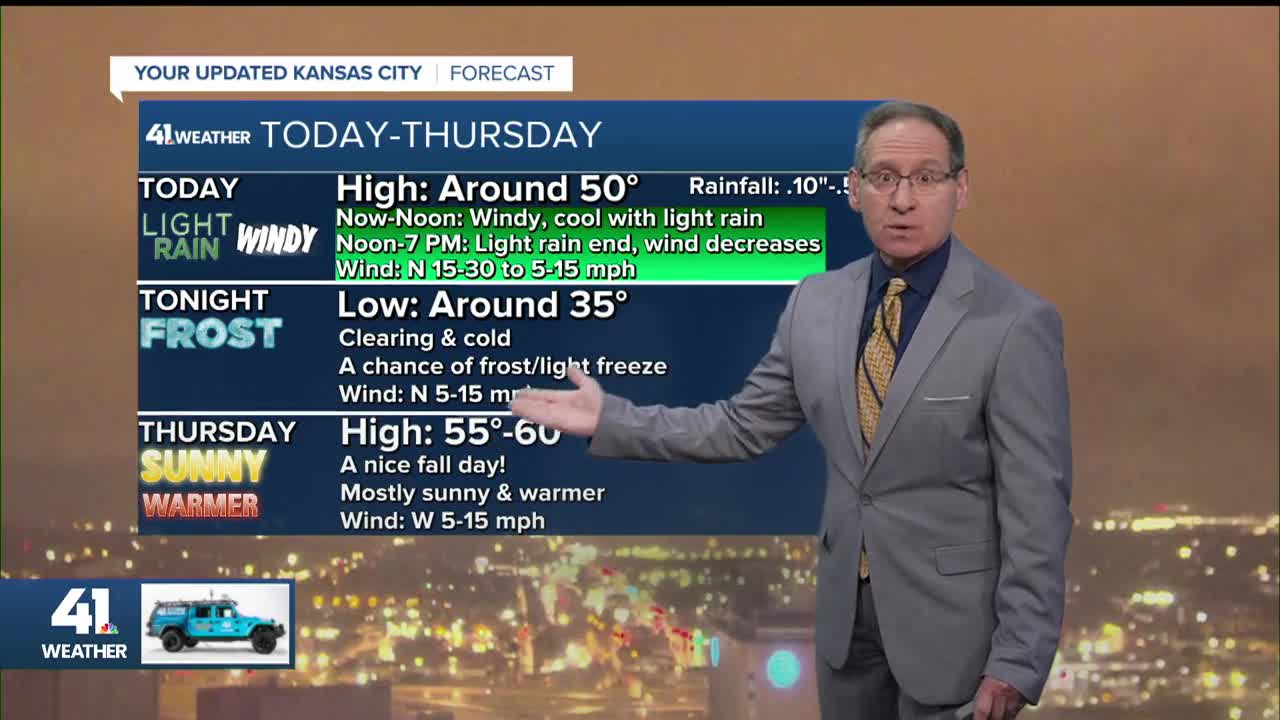
The storm system as of 6 a.m. Wednesday was located near Memphis, Tennessee. The back edge of the rain for us was around Davenport, Iowa. It will take until early afternoon for the rain to end. There will be times this morning when it is barely raining. Once the rain ends, the wind will decrease, followed by a clearing sky tonight.


TONIGHT:
The clear sky tonight with the lighter wind sets up good radiational cooling conditions. This will allow temperatures to drop to the low 30s, which means frost and a light freeze is possible. We are in a frost advisory with freeze watches and warnings to the southwest. It will get colder out there as the air is drier, allowing the temperatures to drop more.


THURSDAY-SUNDAY:
We do not see any rain as a weak system tracks well to our northeast and east Friday into the weekend. We will see a weak front or two go by, meaning highs will be mostly in the 50s with lows in the 30s. Saturday and Sunday mornings the door is open for more frost and light freezes.


MONDAY:
The system to our east will exit and it will allow the 60s and 70s to stream in from the west. So, the first week of November looks calm with much above-average temperatures. Average highs drop from 60° to 57° with average lows dropping from 39° to 37°.

HURRICANE MELISSA UPDATE:
Melissa is now crossing eastern Cuba as a minimal Category 3 as the mountainous terrain of Jamaica and Cuba have weakened it.

Tuesday morning it was a powerful Category 5 with 185 mph winds and, about to make landfall in southwest Jamaica.

Melissa is going to zoom out into the Atlantic Thursday-Friday, affecting Bermuda as a category 1/2. It will be near Greenland by Monday as it becomes post-tropical. It will then combine with a storm system north of England next week and bring rain and wind there.

WEATHER SUMMARY:
The rain ends by early afternoon, followed by frost tonight and a nice Halloween. It will be dry and cool for trick-or-treating.


Have a great rest of your week.
Stay healthy.
