


Good Tuesday, bloggers,
The "March Weather Madness" continues. We had the hottest March temperature ever recorded Saturday (93°), a low of 28° Monday, and now we are looking at highs around 90° Wednesday and Thursday, followed by the chance of a freeze Saturday, March 28.
The record highs for Wednesday and Thursday are 90° and 85°, respectively.
Let's go through this.
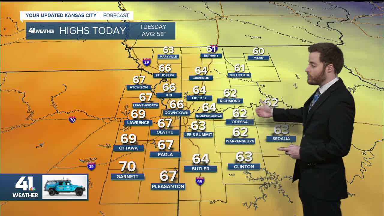
TODAY:
We will see highs in the 60s with a lot of clouds as the warmer air heads back in. The 80s will return to western Kansas.

WEDNESDAY:
The warm front surges in on southwest winds 10-20 mph along with abundant sunshine. This will take our high to around 90°, which could tie the record.

THURSDAY:
We will likely make a run at 90° again, easily breaking the record high of 85°, ahead of the next strong cold front.
The front is timed for 4-7 p.m., which will allow us to warm up, as opposed to last Sunday, when the front arrived at noon and stopped the warming in the 70s.

THURSDAY NIGHT:
The front will move through as a line of rain and thunderstorms forms behind the front from around KC and east. These will not be severe, but a few bigger thunderstorms could produce hail.
It looks like the strongest thunderstorms will be east of KC. Temperatures will be in the 50s by midnight with a north wind gusting to 30-40 mph.

FRIDAY MORNING:
The front will be in southern Oklahoma and Arkansas as the line of rain/thunderstorms tracks south to I-44. We will see temperatures in the low 40s with a north wind gusting to 30 mph.
Lows may drop to the upper 30s, so we will likely not see any mixed sleet/snow.

RAINFALL THURSDAY NIGHT-FRIDAY:
The rain will be concentrated along and south of I-70 as the precipitation will form north of I-70 and increase as it moves south, but then decrease as it heads toward southern Missouri.
Also, there will be a western edge to the meaningful rain, and that appears to be around the state line. The heaviest rainfall will occur east of the Mississippi River, where 1"-2" is possible.

Our area will see mostly a trace to 0.50" with up to 1" possible in central Missouri. The western edge of the rain may end up farther east.

The rain will likely miss the locations that need it the most. Here is the percent average rainfall for the last 30 days.
Northern Missouri to most of Kansas west of I-35 needs a drink or two of water. The changes next week may help.

FRIDAY AFTERNOON:
The wind and clouds will decrease, making for a partly cloudy and cool afternoon with highs in the low to mid-50s. The wind will be north at 10-20 mph.

SATURDAY MORNING:
This is when we have the chance to see a freeze with lows in the upper 20s to low 30s. If the big surface high is more over our area, we will see lows 25-30. If the high is farther east, as shown, it will be 30-35.
Either way, we have another huge temperature swing on the way.

SATURDAY AFTERNOON:
It will be a nice day with highs in the 50s to low 60s and a south breeze 10-15 mph.

SUNDAY:
The next warm front will be moving in along with clouds. If the warm front is faster, we will reach 75-80. Right now, it looks like we will see highs somewhere between 65 and 75 with a south wind at 15-30 mph.

MONDAY:
It is the home opener for the Royals with the first pitch at 3:10 p.m. It will be a warm and moderately humid day with highs around 80, along with filtered sunshine.
But pitchers beware, as not only are the fences closer, but we will see a south wind gusting to 40 mph, which means blowing out to left center.

AFTER MONDAY INTO NEXT WEEK:
The upper-level high, heat dome, heat wave-creating machine that has been in the southwest U.S. the last two weeks will shift to the southeast.
This opens the door to systems entering the western U.S. from the Pacific and then tracking east and northeast across the Plains and Midwest.
This opens another door to increased rain and thunderstorm chances. Severe weather is always on the table with thunderstorms in April.

Have a great rest of your week.
Stay healthy.
—
