


TGIF blog readers-
We've got a better heat and humidity combo today, yay cold front, but overall it will still be summer-like out there. Highs will push into the upper 80s and humidity is still in the mid 60s. The good news is, the heat index today is basically non-existent so the mercury doesn't need to be adjusted to a 'feels like' trend today.

The sunshine holds for your Friday, but later tonight another round of active weather is lining up to impact the northern Great Plains. While we are tracking rain and thunder, no severe weather is expected tonight or Saturday. Severe weather concerns tonight stay out into western Kansas and by Saturday severe concerns are mainly northwest of Kansas City.


But there are a few waves of rain and thundershowers possible through the weekend forecast. The good news is most the our daylight hours should remain dry for any weekend plans you may have. The heat will be slowly building back in through the weekend, with humidity sticking around as well.

Rain chances are looking to begin to roll toward Kansas City after midnight tonight. Then stick around into Saturday morning. Storm activity should mainly impact northern Missouri but we could see storms as far south as the metro along I-70. Here is a look at what radar could look like by 7 a.m. Saturday.

There is another chance for some rain and thunder Saturday evening, but right now it looks to stay outside the viewing area (more toward Topeka) and fizzle out by the time it gets closer. But keep in mind as we stay unsettled that more rain and thunder is possible Saturday night into Sunday. Right now I don't love the rain hanging around too long into Sunday and expect the sunshine to take over quickly. But make sure to stay up to date with the forecast because we have seen the weekend storm chances bounce around a bit.
Next Week
Next week we've got a heat dome building to our southeast, and this will make for an interesting forecast. Depending on where the heat dome sits we could either see storm chances for multiple days or dry weather and a string of the 90s. The heat dome looks to hit the east coast and this will allow for a the gulf to remain open for business for the Plains. We are tracking storm chances Tuesday and Wednesday of next week right now.
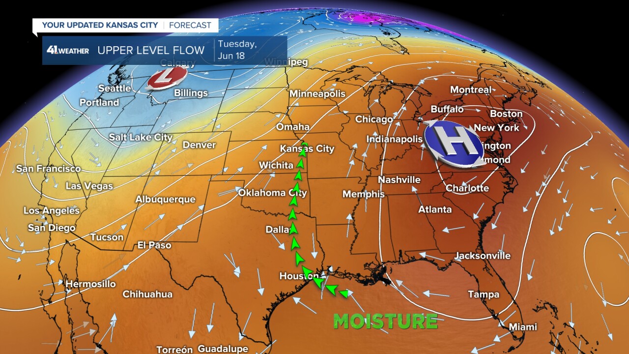
When it comes down to how this heat dome will evolve, models are split. The American model keeps the gulf open and us on the western edge of the heat dome allowing a moist but warm flow into Kansas City. But the European model retrogrades the heat dome, shutting down the gulf flow and instead placing an oven over the Plains. So the wiggle in the placement of the high next week will be everything. We could easily be quickly talking about a string of solid 90s.

For now enjoy your weekend, breathe easy knowing there aren't any big severe weather chances, but also stay up to date with the overnight rain and thunder chances. We will see how long rain lingers each morning!
