


KANSAS CITY, Mo. — Good Tuesday, bloggers,
We are tracking two big weather features early this week: a strong storm system forming in our region and a powerful hurricane getting ready to hit Jamaica very hard.
Let's start with our storm system.
This is the upper-level flow for this afternoon. There is a big block from eastern Canada to the Midwest where an upper-level high is north of an upper-level low.
This block is preventing our storm system from racing west to east, which would mean little to no rain around here.

Here is the upper-level flow for early Wednesday. Our storm has now formed into a closed low in southwest Missouri as it heads southeast and then east.
The block is still in place as our storm system goes around it. You can see a second storm system in central Canada as energy in the jet stream that came into the western U.S. on Monday split north and south due to the block.
One other thing to notice is a small trough south of Miami. That is actually a reflection of Major Hurricane Melissa, which is going to get picked up by our storm system.
We have more on Melissa below.

What does all of this mean? Let's go through this.
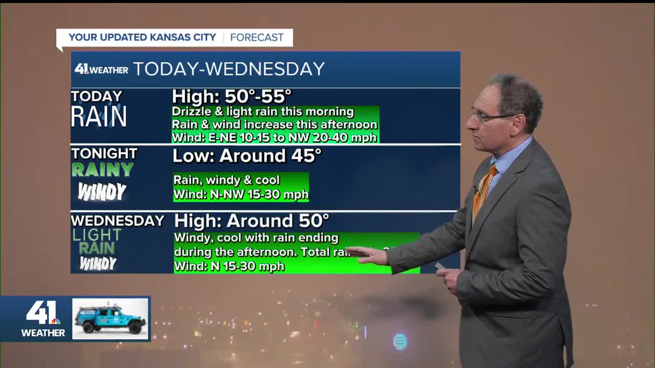
TUESDAY THROUGH NOON:
The drizzle and light rain will increase as temperatures remain in the low 50s. Northwest winds gusting to 30-40 mph will be just west of the state line.

TODAY (NOON-7 PM):
The line of rain will widen and begin to bend a bit as the upper-level low begins to form. We will see steady light to moderate rain, heavy a times, with the wind from the northwest at 20-30, gusting to 40 mph.
Temperatures will drop into the mid and upper 40s. It will be rainy and windy during the evening rush hour.

TONIGHT (7 PM)-WEDNESDAY (7 AM):
It will be a rainy, windy and cool night with winds gusting to 30-40 mph from the north-northwest and lows around 45°.
You can see the rain bent around the center of the upper low that will be tracking to northeast Arkansas by morning. The rain will be mostly light, moderate at times, by morning.

WEDNESDAY AFTERNOON/EVENING:
The storm system will race into the southeast U.S., which means the rain will end during the afternoon and the wind will drop to 10-15 mph by evening. We may even see a few breaks in the overcast by sunset. Highs will be around 50°.
Thursday morning, we have a chance to see a widespread frost/light freeze. It will depend on how clear the sky becomes and how dry the air gets.

RAINFALL FORECAST TODAY-WEDNESDAY:
You can see for the first time in months that we are near the center of the heaviest rain. The storm will produce the heaviest rain across southern Missouri to the Tennessee Valley as it picks up more Gulf moisture.

But we will take what we can get as we are still 7"-8" below average rainfall since July.
When we zoom in, you can see most locations should see at least 0.50". There will be a band where rainfall amounts are between 0.50" to as much as 1.50". At least we all get meaningful rain.

Here is the weather summary for today through Wednesday.

The good news is it still looks dry for Halloween with highs near 60°, dropping to the 40s for trick-or-treating.

MAJOR HURRICANE MELISSA:
This is unfortunately still about as organized as a hurricane can get. There is blue in the eye, which means we can see the ocean in a totally clear eye.
The wind, as of 5:30 a.m., was at 175 mph. It will make landfall in southwest Jamaica this afternoon, which means most of the south coast will be in the most dangerous northeast quadrant of the storm.
All of Jamaica will have massive impacts, but the south coast will take the brunt of the issues.

Here is the track of Melissa. It will make landfall this afternoon west of Kingston, which puts that city in high danger.

Our storm will pick up Melissa and accelerate the storm into the Atlantic Ocean. It will make landfall in central and eastern Cuba on Wednesday as a Category 4 or 3.
It may affect Bermuda by the end of the week as a Category 1 or 2. Melissa will become a tropical storm this weekend as it races across the North Atlantic Ocean.

Have a great rest of your week.
Stay healthy.
