


KANSAS CITY, Mo. — Good Friday bloggers,
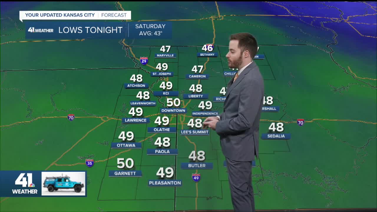
It is no secret that it has struggled to rain in Kansas CIty since the end of July. We are running 7"-8" below average rainfall since the end of July. We will see rain this weekend, but amounts will vary greatly from north to south. The other feature of the weekend is that temperatures will basically run between 50° and 55° day and night with an east wind 10-20 miles per hour.
Let's go through this.
FRIDAY 5-8 AM:
A large area of rain was about 50 miles west and southwest of Kansas City. It has been tracking east and evaporating on the eastern edge. But, it will start evaporating farther and farther east with time, which means it should arrive in Kansas City between 8 or 9 a.m.

FRIDAY (8 AM-3 PM):
We should see a steady light to moderate rain with embedded heavy showers for much of eastern Kansas and western Missouri. But notice there is no rain in northern Missouri and sun in far northeast Missouri.

FRIDAY (3 PM-7 PM):
The steady rain will exit to the east, leaving a few showers and some drizzle.

FRIDAY (7 PM)-SATURDAY (7 AM):
We will see periods of scattered showers and drizzle overnight as a large area of light to moderate rain increases across southern Kansas into Oklahoma.
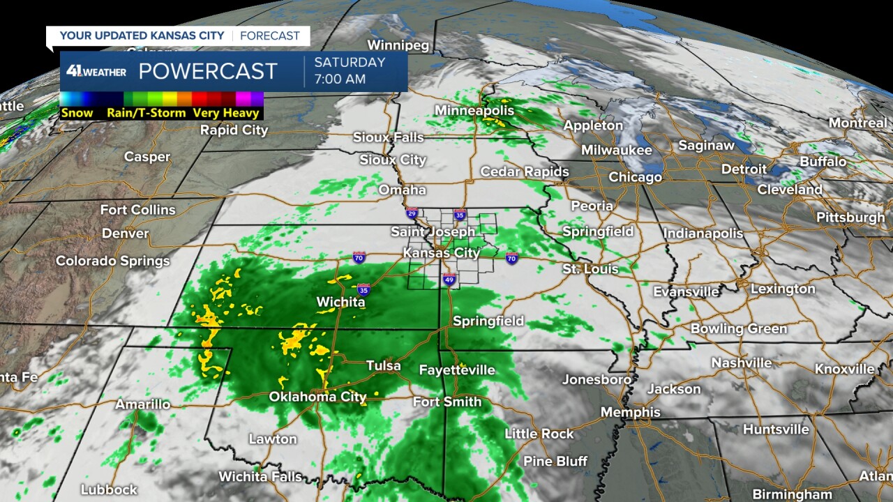
SATURDAY (7 AM-NOON):
The steady rain moves north to just north of Interstate 70.

SATURDAY (NOON-7 PM):
The rain lifts north and decreases, struggling to reach northern Missouri. You can see the center of the upper-level system near Wichita, Kansas.

SATURDAY (7 PM)-SUNDAY (7 AM):
We will see periods of scattered showers and some drizzle as another band of rain rotates north toward I-70.

SUNDAY (7 AM-7 PM):
The band of rain will track north and decrease again, which means we will see periods of drizzle and scattered showers through the day. There may be a period of steady rain during the morning if the band to the south at 7 a.m. holds together to I-70.

SUNDAY (7 PM)-MONDAY (7 AM):
It will be cloudy and cool with periods of mist and drizzle.

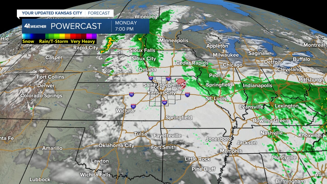
MONDAY (7 AM-7 PM):
The weekend system will be moving into the Tennessee valley as we track a second system to our northwest. Right now, it looks like that system will move through Monday night-Tuesday. So, Monday will be mostly cloudy and cool (lows/highs in the 50s) with a slight chance of rain as it stands now. This means it should be mostly dry for the Chiefs game. There is still some uncertainty on the evolution of the second system, which means the forecast for the Chiefs game is still not set yet.
RAINFALL FORECAST TODAY-MONDAY:
2"-4" with some locations seeing 4"-7" of rain will be found from central Kansas to north Texas. We are on the north edge of the heavy totals.

When we zoom in, you can see rainfall will be .10"-.50" from St. Joseph to Trenton and Kirksville, Missouri. In the Kansas City area, rainfall totals will range from .50"-1" north of I-70 to 1"-2" south of I-70. 2"-4" of rain will be possible from Emporia, Kansas, to west of Clinton, Missouri.
Now, this can still shift north/south by 30-50 miles.

What is amazing is that the heaviest rain is occurring in locations that are mostly not in drought conditions. Here is the latest Drought Monitor through 10/21. You can see the heaviest rain basically cuts off where the worst drought conditions begin. Hopefully, we can get the heavier rain to cross the dry barrier a bit the next three to five days.

SUNFLOWER SHOWDOWN:
There is a very good chance of rain with temperatures in the 50s and an east wind 5-15 mph.

MONDAY NIGHT FOOTBALL, HALLOWEEN:
At this time, it looks mostly cloudy and cool for Monday Night Football tailgating and the game. Temperatures will be in the low 50s with an east wind 5-15 mph. There is a slight chance of rain, but it looks like the 2nd system will keep its rain north of Kansas City, or come in after the game. Confidence is growing, but still not high, in this forecast.
Halloween looks dry and cool. The high will be around 60° with temperatures dropping from the 50s to 40s for trick-or treat time with a northwest breeze at 10-20 mph. I have been trick or treating in Kansas City for 50 years, and I have seen much worse from ice/snow on the ground to it being too warm to wear a costume.
Well, I don't trick or treat now with my son in college, but I hand out candy. And eat it as well. LOL

TROPICAL SYSTEM MELISSA:
One last item is tropical system Melissa.
Melissa is still a tropical storm with 45 mph winds. Between today and Monday night, it will drift west, south of Jamaica and become a Category 4. Early next week, it will turn north and accelerate, affecting Cuba as a Category 3 or 4. After Cuba, it will race northeast to the Atlantic and weaken. It should stay east of Bermuda.

Have a great weekend
Stay healthy
