


KANSAS CITY, Mo. — Good Monday, bloggers,
We have seen three days of clouds and rain, but many locations have not seen much rain from around Kansas City and points northeast.
Well, we have one more storm system to track for Tuesday and Wednesday. It has the potential to bring beneficial rain to locations that did not see much rain over the last three days.
RAINFALL LAST 3-5 DAYS:
There has been a ton of rain from central Kansas to Texas, where 2"-5" of rain was common. You can see we have been on the northeast edge of the heavier rain.

Rainfall has ranged from 0.25" to 0.75" in the Kansas City area to a trace north and east. 1"-2" rainfall occurred from Lawrence to around Fort Scott, south and west.
Note, these are radar-estimated totals, and your rain gauge may read differently.

OK, we have another storm to track.
Will this one bring the rain that is needed in areas that need it? Let's go through this.
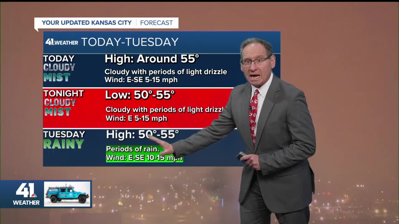
TODAY-TONIGHT:
It will be cloudy and cool with periods of mist and drizzle (BTW, drizzle is just heavy mist). Rainfall will be a trace to 0.03".
Temperatures will stay where they have been for three days, 50°-55°. The wind will be east at 10-15 mph.
This is also the forecast for the Chiefs game tonight against the Commanders.

TUESDAY MORNING:
A band of rain will be moving in from the west as the storm system begins to form in the northern Plains. It will begin to drop south-southeast as it intensifies.
Decent rainfall will occur along and east of its track.

TUESDAY AFTERNOON/EVENING:
The band of rain will swing through during the day, but behind the main band, new rain will form as the storm system starts to intensify and drop south-southeast.
The high Tuesday will again be around 55° with an east wind of 10-15 mph.

TUESDAY NIGHT-WEDNESDAY MORNING:
The storm system will be forming into an upper low. On this data, the upper low forms/tracks through western and central Missouri.
The farther west it tracks, the more rain we see. This data has us on the western edge of the decent rain.
Tuesday night will become windy from the northwest with gusts of 30-40 mph, along with rain and lows in the 40s.

WEDNESDAY AFTERNOON:
The storm system will race away, meaning the rain will end and the wind will decrease. Highs will reach the low 50s.

RAINFALL FORECAST:
As of this moment, it looks like the heaviest rain, 1"-2", will track from central Iowa to eastern Missouri and the Tennessee Valley.
The 2"-4" rainfall in the Tennessee Valley is a combination of the storm system that we had here over the weekend and the second one on the way.

When we look closer, you can see we are on the southwest edge of the heaviest rain. Yes, we were on the northeast edge of the heavy rain from the first storm, and now we are on the southwest edge of the heavy rain from the second storm.
Now, can this still shift west by 50-100 miles? YES!
The storm system has not formed, and we have data all over the place on the track of the storm. This also means it can shift east by 50-100 miles.
As of now, we will go with us being on the southwest edge of the rain since the last time we were in the middle of the heaviest rain has been months.
If we take this forecast as is, rainfall in Kansas City will be around 0.50" with 0.50" to 2" northeast to a trace to 0.50" southwest.
We will know much more tomorrow as the storm system will be getting its act together.

MAJOR HURRICANE MELISSA:
This hurricane is about as organized as a hurricane can get as of 5-6 a.m. Monday. It is a Category 5 with 160 mph winds, located south of Jamaica.

Unfortunately, it will make landfall in the middle of Jamaica as a Category 5 on Tuesday.
It will begin to accelerate, affecting Cuba as a Category 3 on Wednesday, then take off into the Atlantic and affect Bermuda Thursday-Friday as a Category 2.

WEATHER SUMMARY:

If you are headed to GEHA Field at Arrowhead Stadium for the game, it won't feel that bad out initially, with temperatures in the low 50s.
But when you stand outside for five, 10, 15 hours with temperatures in the low 50s, it can feel cold. Mist and drizzle will be around as well.
Halloween still looks dry with highs around 60. Temperatures will drop to the 40s during trick-or-treating. The wind looks to be about 5-15 mph.

Have a great week.
Stay healthy.
GO CHIEFS!
—
