


Good Monday, bloggers,
We are currently sitting at the third warmest January in recorded history. The next two days, we may get close to the warmest on record.
But it is only Jan. 12, and the first of 3-4 cold fronts arrives Wednesday. This will bring the average monthly temperature down.
Let's go through this.
The weather pattern during the next week will feature a big ridge across western North America and a big trough across eastern North America. This means locations from the Rockies to the West Coast will be dry with mostly above-average to much-above-average temperatures.
Locations to the east of the Rockies will see a series of cold fronts with mostly light precipitation. New England will be the stormiest with several chances of snow.
The biggest snow may stay away from the coast.


Let's go through the details.
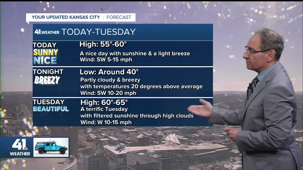
TODAY:
We will see abundant sunshine with highs in the upper 50s to low 60s, along with a southwest breeze 5-15 mph.


TONIGHT:
The wind will increase from the west and southwest. This will keep lows around the average high for this date.
This means lows will be 35°-40°.

TUESDAY:
We will see highs climb to the low and mid-60s. The record is 68° set in 1996.
Right now, it looks like we will fall short of the record by a few degrees. The wind will be west-southwest at 10-20 mph.


While we are enjoying the unseasonably warm weather Tuesday, the first of 3-4 cold fronts will be moving across the U.S.-Canadian border.

TUESDAY NIGHT:
The Wednesday high will likely be around midnight with temperatures around 50°.
A few rain showers are possible as we await the first cold front.

WEDNESDAY:
By 7 a.m., temperatures will be dropping into the upper 30s, and there may again be a few rain showers. Total rainfall will be a trace to 0.03".
The wind will be picking up from the north-northwest with gusts to 30 mph.

The rest of Wednesday will be partly cloudy and windy with falling temperatures. By 7 p.m., temperatures will be in the upper 20s.
The wind all day will be north-northwest at 20-30 mph, gusting 35-40 mph.

The front by Wednesday afternoon will have traveled to Oklahoma from the U.S.-Canadian border 24 hours prior.


THURSDAY:
The warm front in the Rockies will begin to head our way with the 60s back to western Kansas. We will see increasing clouds with highs in the 30s.

FRIDAY:
We will not see highs in the 60s because the second cold front will be racing south quickly.
So. Thursday night-Friday will have a chance to see scattered rain and snow showers with temperatures in the 30s and 40s.
We do not expect any accumulation.

The third and fourth cold fronts are due in next Sunday-Tuesday. When is our next chance to see measurable winter precipitation? There will be 1-2, maybe 3, chances between Jan. 23 and Feb. 4.
Have a great week ahead.
Stay healthy.
—
