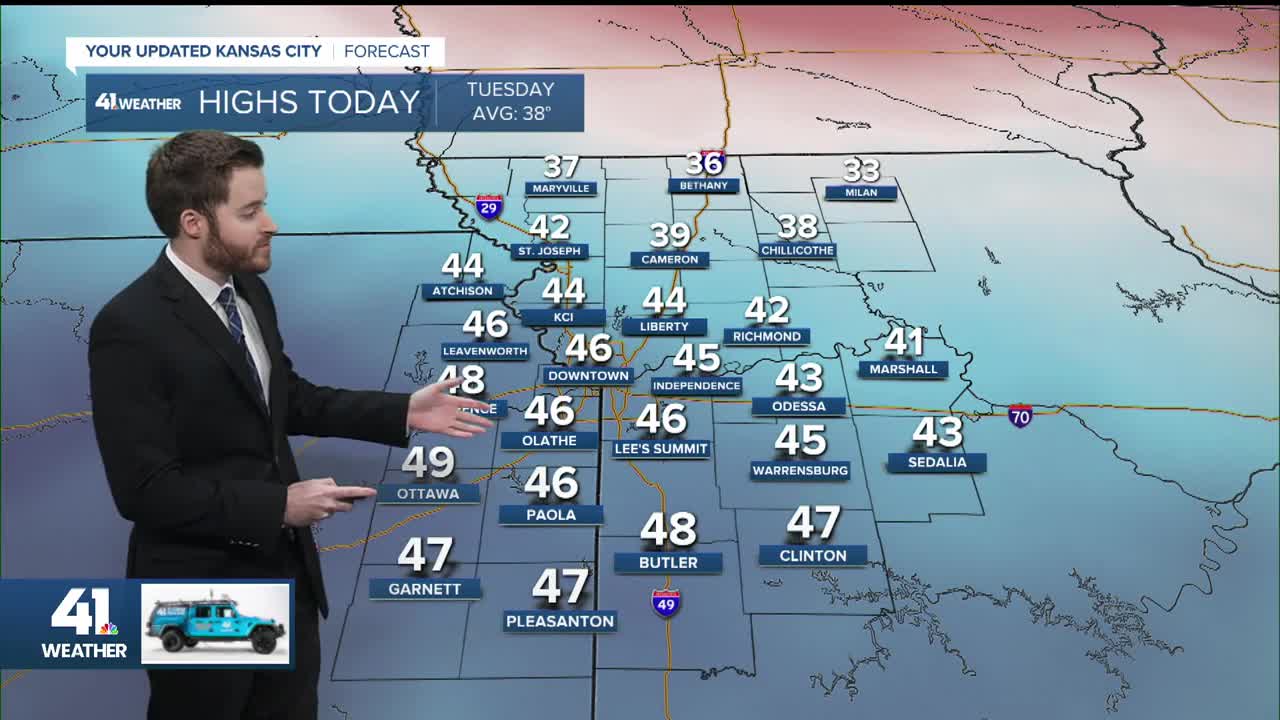


Good Tuesday, bloggers,
The weather today through Thursday will be rather calm with near- to above-average temperatures.
WEDNESDAY:
A weak cold front will move through during the evening. We will warm well into the 40s ahead of it.

THURSDAY:
The Wednesday front will drop our highs to the upper 30s as we await the much more significant Arctic front timed for Thursday night.

FRIDAY:
It will be brutally cold with highs in the teens and wind chill values around -10. Highs will struggle to zero in Iowa and struggle to -10 in Minnesota.
There will not be much, if any, snow with the Arctic front. But you can see snow starting to increase in the western Plains as the major storm starts to form.

SATURDAY:
This is the day when the major winter storm really gets going and where there are major model discrepancies.
First, there is not much disagreement on the fact that we will see highs in the low to mid-teens. Highs will struggle again to get to zero in Iowa and -10 in Minnesota. Wind chill values here will again be around -10.

Now, to the potential major winter storm. One of the biggest issues is how far north the snow will extend.
The Euro model is shown below and has us receiving accumulating snow. If it snows at 10 degrees, it can accumulate fast as every flake sticks.

When we look farther south at 9 a.m. Saturday, you can see our area is at the tip of the iceberg of the storm. A major ice/snow storm is raging from the southern Plains to the southeast U.S.
This is the Euro model.

Here is the American model solution valid at the same time as the map above, 9 a.m. Saturday. The precipitation shield is about 200-400 miles farther south, and the precipitation is a bit lighter.

What is going on? Well, we look to the upper-level flow as this is where the upper-level storm systems form, and this dictates what goes on at the surface.
EUROPEAN MODEL UPPER-LEVEL FLOW SATURDAY:
We are tracking two branches of flow, the northern and southern branches. The northern branch is heading south and picking up a moisture-laden system in the southern branch near Baja, California.
If these branches combine, it becomes an enormous storm as tons of warm and moist air will overrun a large and intense Arctic air mass. This creates a huge area of rain, ice and snow.
Our area is in a west-southwest flow, getting moisture from the southern branch, which allows the Gulf flow to reach our area.
This solution brings snow to KC as the overrunning will be able to make it this far north. Since the air above us is all below 32°, we get snow.

AMERICAN MODEL UPPER-LEVEL FLOW SATURDAY:
The northern branch is not picking up the southern storm. And you can see there is much more disorganization in the flow.
This translates to not as big a precipitation shield and one that is much farther south as the moisture-laden southern branch flows farther south.
Our area is in a west-northwest flow, the drier northern branch, as the northern branch was not able to connect fully with the southern branch.

So, what is right? Right now, we have a split on solutions from other models as well.
At this point, four days before the storm, it is literally 50-50. It will become clearer in the next 1-2 days.
Regardless, be aware of the dangerous cold that arrives Thursday night-Friday and exits early next week.
Have a great rest of your week.
Stay healthy.
—
