


Good Wednesday bloggers,
We have seen our temperatures drop from 30-35 degrees above average to 10-15 degrees above average this week. Early next week, we may see temperatures return to 30-35 degrees above average. The average high early next week is 44°. So, yes, doing the math, a return to highs in the 70s is possible.
The other item is a Valentine's Day storm system. Let's go through this.
VALENTINE'S DAY STORM SYSTEM:
The storm today is near San Francisco. This system will track southeast toward southern California and then head east into the southern Plains and Friday and Saturday.

This is the upper-level flow for Saturday. The center of the storm system is near the Red River on the Oklahoma-Texas border. There is just enough of a northern extension so that the precipitation will make it most likely to Interstate 70. A shift of 50-100 miles north or south is still possible and will make a huge difference in the weather for Valentine's Day in your location.

Before the storm system, we will see calmer weather on Thursday and Friday with lots of high and mid-level clouds. Highs will be in the mid/upper 50s to low 60s. Right now, Friday looks the warmest as we may see a bit more sunshine than we will Thursday.
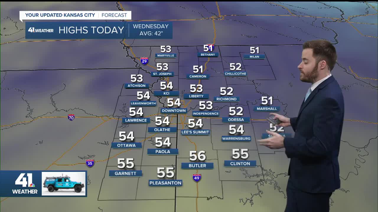
There may be a sprinkle Thursday, but overall it will be dry and mostly cloudy with highs in the 50s and a south breeze 10-15 mph.

Friday will be a nice day with a partly to mostly cloudy sky, high around 60° and a light wind. Rain will start to increase across southeast Kansas, southwest Missouri, eastern Oklahoma to western Arkansas as the storm system approaches.

VALENTINE'S DAY MORNING:
Rain will be spreading in from the south, getting to around I-70. You can see there is no snow anywhere, as it is too warm in all areas with temperatures in the 40s.

VALENTINE'S DAY AFTERNOON:
On this data run, the rain spreads as far north as U.S. Highway 36. This northern edge could end up as far north as the Iowa border, or as far south as 20 miles south of Kansas City. At this time, we're leaning with this solution.
Highs will be 45°-50° where it is raining and in the 50s to possibly low 60s where it is not raining. The wind will be northeast at 10-20 mph, making it a chilly and wet day, but it is February and it can be a lot worse.
The rain will exit Saturday night as the storm moves east.

RAINFALL FORECAST:
Based on the above solution, amounts will range from nothing near the Iowa border to 2"-4" south of Interstate 44. This puts Kansas City on the .05"-.50" range from north to south. You can see how a shift of 50-100 miles can make a difference of no rain in KC or .50"-1".

When you look at the big picture, the only snow through Sunday will occur in the mountains of the west and New England.

SUNDAY:
Sunday will be a nice day regardless of the storm track as the storm system exits Saturday night. We will see increasing sunshine and highs in the low 60s with a light wind.

Now to the record high potential part of the blog.
This is the upper-level flow for Monday. The Valentine's Day storm system has tracked southeast into Florida while a huge storm forms off the west coast of the USA. In between, there is a big non-storm, also called a ridge, in the middle of the USA, centered in our area. This means near record/record warmth is possible.

The record high temperatures for Kansas City next Monday-Wednesday are 74° each day set in 1961, 2017, and 2016, respectively.
MONDAY:
We are going with upper 60s, but it could easily reach 70°-75° if the warmer air at 3,500 feet reaches our area by afternoon. The air at 3,500 feet is brought down to the surface by mixing, and when that happens, it warms. So, the warmer it is at 3,500 feet, the warmer at the surface.

TUESDAY:
This is the day when we have a chance to tie or break the record as the warmest air of the three days is over us, and we will have a south-southwest wind gusting over 40 mph. The one limiting factor is that we may see thick, high and mid-level clouds. But, the clouds may limit us from reaching 80° and not the record.
Also, notice there is a spring-like severe weather setup at the surface. There is a low pressure in northeast Nebraska with a cold front extending west, a warm front extending east, and a trough/dry line extending south. This is a "triple point." The big limiting factor for thunderstorms is that there is not nearly enough low-level Gulf moisture.

WEDNESDAY:
The cold front up north will head south and stall. South of the front it will be 70°-75° while to the north it will be 65°-70°. And, of course, Kansas City is right near the front. So, if we are to break the record of 74°, we need that front to stay north.

Have a great rest of your week and weekend and a lovely Valentine's Day.
Stay healthy
