


Good morning bloggers,
The weather pattern almost produced thunderstorms this morning. Thunderstorms north of Kansas City produced an outflow boundary of rain cooled air, but it is weakening and it will likely fall apart. It is more likely to bring a little relief to northern Missouri today. Here is that outflow boundary as of 7:16 AM:

Thunderstorms are near the Missouri/Iowa border are being monitored closely. These thunderstorms are fairly active around Maryville early this morning, and they may make it to near or just north of KC this afternoon. There may be some strong wind gusts from the thunderstorms and heavy rain. These areas will be cooler than 90 degrees today.
Today's Upper Level Flow:

The "heat wave creating machine" anticyclone is developing over Kansas today. The main jet stream is way north, but here is the good news: The jet stream will be strengthening as the first colder air masses of the fall begin forming in Canada during the next three weeks. This will eventually blast summer right out of here! For now, we have some more strong summer weather to deal with.
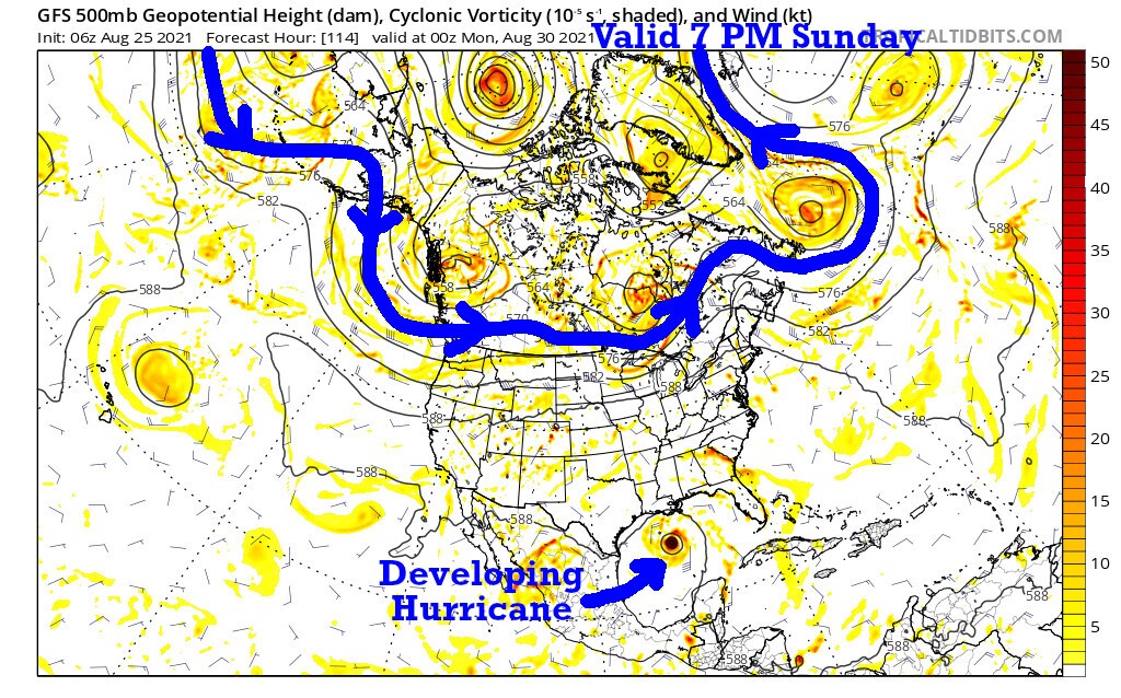
By the end of this next weekend the jet stream is already beginning to drop south, and look closely; a hurricane will be developing in the Gulf of Mexico with a threat near the Texas/Louisiana border area. This may very well end up being one of the best LRC predictions we have ever made, and I will share more of that with you in the coming days. Let's let it happen first. I predicted that August 29th would see a hurricane almost exactly where this one is forecast to develop now:


Again, we will go deeper into this prediction made last October, almost a year ago, and then firmed up with that exact date of August 29th. For now, it has not formed yet. For now, it is just beginning to form.
Kansas City Weather:
- Today: A small band of showers and thunderstorms will track very slowly over areas just north of I-70. There may be a few downpours, some lightning, thunder, and wind gusts. Most other areas will be mostly sunny, hot, and humid. Northern Missouri will likely be a few degrees cooler than the rest of the area. High: 86° North of KC and 96° south. Heat Index: 106°
- Tonight: Warm and humid. Low: 77°
- Thursday: A few morning clouds, then sunny & hot. High: 96°
Thank you for spending a few minutes of your day reading today's blog and sharing in this weather experience. I will be heading back from Tulsa later this week. I am at the National Weather Association Conference. This has been a great meeting. Have a fantastic day!
Gary
