


Good Wednesday bloggers,
There are a lot of cities that claim, "if you don't like the weather just wait five minutes." Well, around KC we mean it. We are going to get another prime example of that statement on Thursday as we track a two-part storm system and one very strong cold front.
So, let's go through this. We will start with a big picture view.
THURSDAY MORNING:
We are in rain as part #1 moves through. You can see rain here with snow and ice across Nebraska into South Dakota. There is a second area of rain to snow in New Mexico/Texas panhandle to Colorado. This is part two. If we are going to see snow, it will depend on the strength of the second part of this storm system.

THURSDAY AFTERNOON:
The first part is now mostly east of the Mississippi river. We are seeing a new area of rain with the second part. We may see drizzle and a few showers in between the parts as temperatures drop.
As of 5 p.m. there is no snow, it is all rain. Also, notice the severe weather breaking out over eastern Oklahoma and western Arkansas into eastern Texas. There is a level 2/3 of 5 risk of severe weather there on Thursday.

THURSDAY EVENING:
The area of rain rapidly changed to snow. Notice, it is a 30-50 mile wide area which, if it forms, will make it difficult to track as a slight shift north or south will make a huge impact on where it snows.

ST. PATRICK'S DAY:
It will be windy and cold with highs around 40° by afternoon. Lows will be 20°-25° with wind chill values in the single digits and teens. New data is a bit warmer for the afternoon with a chance to see less wind. But, there may be a few rain, graupel and snow showers around.

Now, let's get a closer look at this weather March Madness.
THURSDAY (7 A.M.-NOON):
There is a good chance for rain with temperatures 55°-60°. The wind will be south at 15-25 mph.

THURSDAY (NOON-2 P.M.):
We may see a break in the rain with just a few showers around as we will be in between the two parts of the storm. Now, the cold front will be moving through and it may generate a thin line of thunderstorms and heavy showers. KC is 60° and it is 10-20 degrees colder just to the northwest. The line of red arrows is the cold front, I did not draw in the typical blue with triangles front.

THURSDAY (2-6 P.M.):
The front is now east of Sedalia and our temperature has dropped to 40°. Also, note the small pinkish purple areas. The rain is trying to change to snow.
We have gone from 60° to 40° with rain in just 2-4 hours.

THURSDAY (6-8 P.M.):
Boom! Just like that the rain is all snow as our temperature drops to 33° along with a north-northwest wind at 20-40 mph. If it snows hard enough, it will stick to all surfaces, especially since temperatures will be rapidly dropping. This model depicts a 30-50 mile wide band. One, will it form? Two, if it forms where will it actually set up?
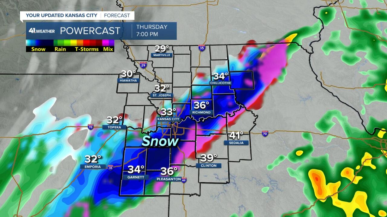
THURSDAY (8 P.M.-MIDNIGHT):
Temperatures will drop to the upper 20s with north-northwest winds 20-40 mph. There may be lingering areas of light snow. Wind chill values will be in the teens.
Roads will be slick if we see the snow. If we do not see much snow then roads may see patchy black ice as there will be left over water from the rain freezing. Some of the water will evaporate before it can freeze if there is no snow. Any snow will greatly increase the road slickness. And it will be a "flash freeze" type of situation in both scenarios as temperatures will be dropping fast.

FRIDAY MORNING:
It will be very cold to say the least. Temperatures will be around 20° with wind chill values 5°-15°. The sky looks to be clear, so at least sunshine will help during the morning.

FRIDAY AFTERNOON:
Highs may reach 40°, but a disturbance may bring a few rain, graupel snow showers. The wind will be northwest at 10-20 mph.

RAINFALL FORECAST:
.25"-.50" is likely for most locations. If there are any thunderstorms, amounts in a few locations may see .50"-1".

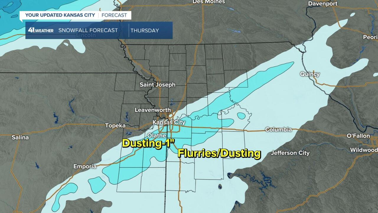
SNOWFALL FORECAST:
In the band of snow there will be a dusting to 1". The location is still not set yet. And, a dusting to 1" does not sound like much, but it will be enough to cause slick roads in this situation.
WEATHER TIMELINE SUMMARY FOR THURSDAY:
There is a lot on the below graphic. But, there are a lot of weather changes on Thursday.

Now, just like always, nothing is set yet. But, there is a bit of a trend to some snow.
Have a great rest of your week.
Stay healthy.
